Daily insights for city builders, delivered every morning at 6 AM ET. I’m Brandon Donnelly — a Toronto-based real estate developer and founder of Globizen. I’ve been writing here since 2013.

Tag: rail

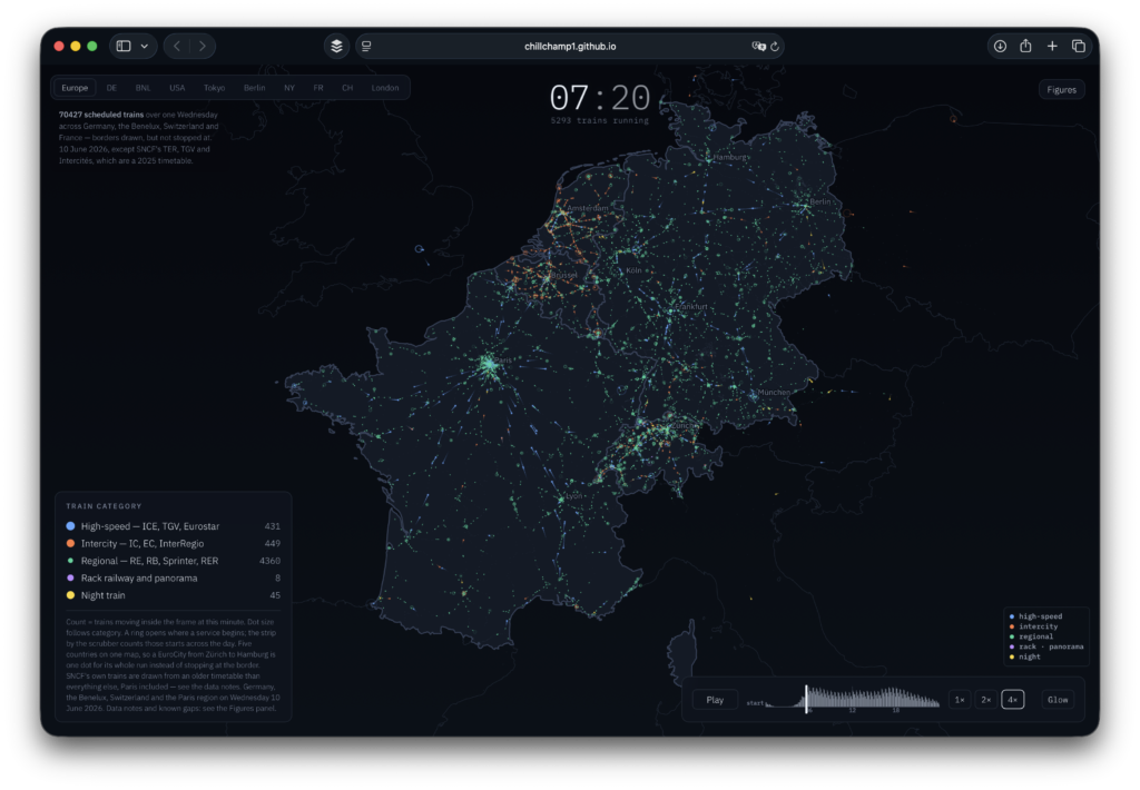
  • Mapping 70,000 trains across Europe

    I just came across a fascinating visualization of rail in Europe. You can also visualize other places like the US, but as you know, there isn’t much to see there in the way of trains. What is shown in the above screenshot is Germany, the Benelux, Switzerland, and France. I paused the visualization at 7:20 AM and there were 5,293 trains running, with the vast majority of them (4,360) being regional rail.

    Here’s what stood out:

    • France operates a monocentric hub-and-spoke network with Paris as the clear central hub. Trips almost always route through Paris, which reflects France’s historically centralized economy. In contrast, Germany operates a decentralized mesh network with more point-to-point travel and no single dominant city.
    • Regional rail is the workhorse. When I paused the visualization, over 82% of the trains in operation were regional rail. High-speed rail is sexy, but it clearly needs to be supported by a dense regional grid that brings people to and from major high-speed routes.
    • Smaller countries like Belgium, the Netherlands, and Switzerland have such a dense network of intercity rail that they almost read as continuous urban regions.

    If you love trains, as I do, you’ll want to take a look.

  • Traffic is agonizing, maybe we should try something new

    The other day I asked my dad how a function he attended went, and he responded by saying, “Traffic, BRUTAL. Traveling by car is an agonizing experience.” He’s not wrong, and I know most of us in Toronto like to complain about it. Traffic is one of the negative externalities of a big city.

    But here’s the thing: we know how to solve this problem. You price congestion, as has been done in New York, London, Singapore, and many other cities, and then direct the revenue it generates to a mode of transport that isn’t as agonizing in a big city: rail travel.

    I’ve written so much on this topic over the years that there’s very little I can add at this point. If you’d like to have a read, here are the search results for “congestion pricing.”

    While the policy has proven successful elsewhere, political inertia and valid concerns over equity keep Toronto stuck. But until we charge for valuable road space, gridlock remains our default. New York City has also shown us that once people see the benefits, they quickly change their minds.

  • How far you can travel in Europe by rail in 5 hours

    Here is a neat tool (created by Benjamin Td) that allows you to quickly see how far you can travel in Europe by rail in 5 hours. The way it works is that you just hover over a train station and then the relevant isochrone will show up. Above is what that looks like for Paris’ Gare de Lyon, which has one of if not the largest catchment areas from what I can tell after playing around with the tool for a few minutes. The data being used to power this map is from Deutsche Bahn. And if there’s a transfer on any of the routes, the tool assumes you can make that happen within 20 minutes, which may or may not be realistic. Regardless, it’s fascinating to see just how connected (or disconnected) some cities are. It’s also a shameful reminder that a North American version wouldn’t be nearly as impressive.

  • China is building and megalopolises are now national policy

    Well here are some interesting figures (via MIT Technology Review):

    • In the past two decades, about 400 million people moved into China’s cities — so more than the entire population of the United States
    • By 2035, about 70% of China’s entire population is expected to be urban (up from 60% today and up from 30% two decades ago)
    • To accommodate this scale of growth, China’s national urban development approach has shifted to something that now revolves around city clusters, or megalopolises (term coined by French geographer Jean Gottmann back in the 1950s to describe the Boston-Washington corridor in the Northeastern US)
    • By 2035, there are expected to be five major city clusters (see above)
    • One of the reasons for this is to improve cooperation across the various clusters — less competition and less redundancy
    • But it’s also about creating smaller more manageable cities — is this what one needs to do after a certain scale, go polycentric?
    • To service these clusters, China is rolling out a network of 16 new high-speed rail lines
    • By 2035, China expects to have 200,000 kilometers of rail, with a third of it being high-speed — assuming this happens, China will be home to 60% of the world’s high-speed rail coverage
    • Current cost estimates for the construction of this network comes out to about US$150 million per kilometer
    • 1-2-3 Rule: The plan is that everyone should be able to get around a city within 1 hour; a city cluster within 2 hours; and travel between the country’s clusters inside of 3 hours

    China is building.

  • How coffee grew São Paulo

    For all of us who are involved in the building of cities, it is important to remember that cities emerge and thrive as a result of economic purpose. Take, for example, Sao Paulo. Once one of the poorest of Portuguese colonies, it is today the largest city in the southern hemisphere and one of the largest and most diverse urban agglomerations in the world.

    How did all of this happen? It was probably because of coffee.

    Brazil is the largest producer of coffee in the world. And it has owned this title for some 150 years. The best areas to grow coffee (as a result of climate, I’m told) are in the southeast part of the country, in and around Sao Paulo and Rio de Janeiro. The inland state of Minas Gerais is the biggest producer.

    But here’s the thing. Rio de Janeiro is along the coast and Sao Paulo is not, though as of 1869 it had been connected to the port of Santos by rail. This geographical feature made Sao Paulo a logical place for rail to converge as it made its way from the coffee plantations in the interior of the country to the coast, and then out to the rest of the world.

    Coffee was the economic purpose. And it was facilitated by Brazil’s longstanding use of slave labor.

    In 1888 that changed. Slavery was abolished, giving Brazil the dubious distinction of being the last country in the Western world to do so. The problem is that the coffee industry relied heavily on this labor. So to fill this void and keep the coffee industry happy, a deliberate effort was made to increase immigration.

    From 1870 to 2010, about 2.3 million immigrants settled in the state of Sao Paulo, many from Italy and Japan. Today, about half of the city is thought to have at least some Italian ancestry. And it is generally believed that it was this significant influx of immigrants that helped the city to industrialize in the way that it did.

    Big and diverse. And coffee probably had a lot to do with it.

    Photo by ViniLowRaw on Unsplash

  • Pritzker Prize-winning architect Kazuyo Sejima designs Japanese commuter train

    In commemoration of the company’s 100th anniversary, Japanese rail operator, Seibu, recently unveiled a new commuter train designed by Pritzker Prize-winning architect Kazuyo Sejima. Sejima is a founding partner in the Tokyo-based firm SANAA, which has started branching out beyond buildings. She recently designed a neat and multi-functional bag for Prada.

    One of the key features of the “Laview” commuter train is its unusually large 1.35m x 1.58m windows. They’re designed to maximize views, as this particular route travels from the city and into the mountains. It’s a simple design move, but it’s one I have never seen before. The overall result is quite beautiful and it goes to show you just how much the Japanese value train travel.

    Images: Dezeen

  • Blue lights on train platforms

    Sadly, Japan has one of the higher suicide rates in the world. According to the World Health Organization, the rate from 2000 to 2016 was about 18.5 deaths per 100,000. The only country in Asia with a higher rate is South Korea. They are at 26.9 deaths per 100,000 (an alarming figure). For comparison, Canada and the US are at 12.5 and 15.3, respectively, which also seem rather high to me.

    I was intrigued to learn today that one of the ways that Japan has been trying to combat this high figure is by installing blue LED lamps on some of its railway platforms. Blue lights have been proven to have a calming effect (compared to white light). And since jumping in front of a train is unfortunately a common suicide method, blue lights were thought to maybe be a cost effective alternative to platform screen doors.

    The first blue station lights were installed on Tokyo’s Yamanote line in 2009. And according to this 2013 study – which looked at the possible impact across 71 train stations in Japan – the introduction of blue lights actually resulted in an 84% decrease in the number of suicides. Further studies also showed that there were no corresponding increases at other non-blue light stations. 

    It is an interesting example of “nudge theory”, but does it get at the root of the problem?

    Photo by Athena Lam on Unsplash

  • Microsoft Canada moving to CIBC Square

    image

    Today, Microsoft announced that it will be moving its Canadian headquarters from Mississauga to the new CIBC Square development that is currently under construction in downtown Toronto (and rendered above). 

    According to RENX, Microsoft will occupy 132,000 square feet across 4 floors in the first tower. Occupancy is scheduled for September 2020.

    I love this project. The design architect is WilkinsonEyre. And there’s going to be an elevated one-acre park spanning the rail corridor between the project’s two towers.

    But it’s also noteworthy because it is an example of a major suburban tenant deciding to relocate to a transit-oriented urban environment. (I have a post on this somewhere.) 

    Image: WilkinsonEyre

  • Local rail-driven agglomeration economies

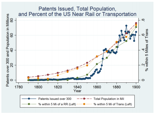
    This morning I came across the below graph in a Medium article by Eric Jaffe of Sidewalk Labs. It is taken from a research paper by Elisabeth Ruth Perlman called, Dense Enough To Be Brilliant: Patents, Urbanization, and Transportation in Nineteenth Century America.

    What this chart shows is patents issued – a proxy for innovation – in all U.S. counties between 1790 and 1900. This data is then compared against access to transport, such as rail. The discovery is a statistically significant relationship between innovation (patents issued) and rail (transport) access.

    The spike in the 1850s (shown above) is as a result of increased rail access.

    But Perlman takes it a step further and asks: what is causing this spike in innovation? Is it because inventors and creators started responding to the larger market now accessible to them because of rail connectivity? Or did transportation somehow improve productivity and the flow of information?

    To answer this question, she dug into the patents themselves (over 700,000 of them) to try and identify how ideas and key words were spreading. What she found is that rail access alone doesn’t encourage innovation. References to new technologies did not increase.

    What mattered was what happened locally. Transportation improvements promoted urbanization and density during her study period, and that’s what drove innovation. Connectivity created agglomeration economies at the local level.

    Obviously a lot has changed since the 19th century. But whether it’s rail connectivity or internet connectivity, have the rules really changed? Place still matters. What happens locally still matters. Perhaps even more. 

    This is an important lesson to consider as we build our cities and invest in transportation. Rail alone isn’t enough. What matters more is what we build around it. Are we dense enough to be brilliant?

  • European cities by rail connectivity

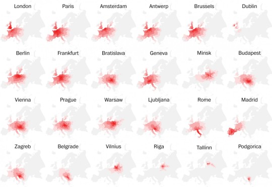
    This is a terrific set of maps published by The Washington Post (2015) using data originally collected and published by Peter Kerpedjiev:

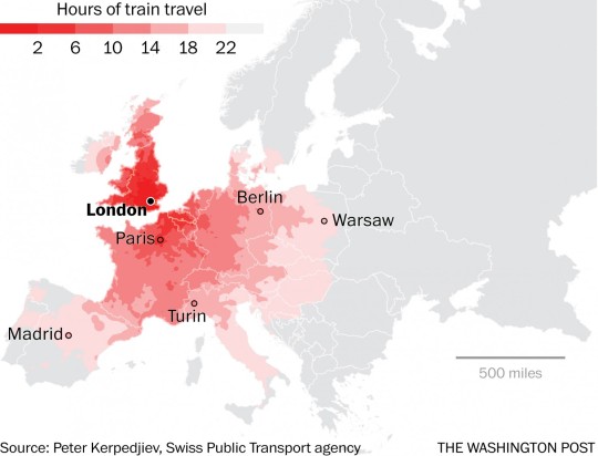
    What they show is how far you can travel in a 24 hour period using only trains and brisk walking from a collection of 28 European cities. In a few cases, such as from London to Dublin, a ferry ride is also included.

    Here’s a zoom in on London:

    The obvious takeaway is that Western Europe is very well connected, whereas many parts of Eastern Europe are not. Some cities, such as Tallinn (Estonia) and Podgorica (Montenegro) are almost completely disconnected.

    Of course today there’s stiff competition from air travel.