Daily insights for city builders, delivered every morning at 6 AM ET. I’m Brandon Donnelly — a Toronto-based real estate developer and founder of Globizen. I’ve been writing here since 2013.

Tag: queens quay

  • Salt Lake City wants to turn Main Street into a pedestrian promenade

    Last year, I wrote about how Salt Lake City wants to build a new linear park around its downtown. That post can be found, here.

    Fast forward to today, and the city’s Department of Economic Development has just published a new comprehensive 215-page study that supports turning Main Street into a pedestrian promenade.

    Specifically, the area running from South Temple to 400 South, and including 100 South from Main to West Temple:

    As part of the study, they highlight a number of successful case studies from around the world, including 16th Street Mall in Denver, Bourke Street Mall in Melbourne, and Queens Quay here in Toronto.

    In the case of Denver, they cite the one-mile stretch as single-handedly generating over 40% of the city’s total downtown tax revenue! And in the case of Toronto, they refer to Queens Quay as a global destination. (Toronto readers, do you agree?)

    Like most city building initiatives, this vision is will take years to realize. But it’s interesting to note that, of the eight design alternatives included in the study, there is already one clear preference within the local community — option B.

    Option B is a pedestrian/transit mall, but with multi-use trails. In other words, it is a no-cars-allowed alternative that would still allow bicycles and scooters. Here’s the street section:

    If you’d like to download a copy of the full Main Street Pedestrian Promenade Study, click here.

  • Bike sharing around Toronto

    I love cycling. And I have been using Toronto’s bike share system to get around over the last few weeks (both for work and personal stuff). There’s no better way to get around when the city is busy. But it was also a reminder that we have a lot of work to do when it comes to cycling infrastructure.

    Here are a few observations:

    • The Bike Share mobile app has got to be the worst app that I have ever used. First of all, it’s called PBSC. I think this was a deliberate choice so that it’s impossible to remember and impossible to locate on your phone. Because once you do find it, it’s an awful experience.
    • I struggled to make it from downtown up to midtown a few days ago. Can I blame the Bike Share bike instead of my lack of physical conditioning? I can’t see the majority of people wanting to do this sort of ride. This is where e-bikes and e-scooters come in.
    • Many of the bikes have something wrong with them.
    • We don’t have enough bike lanes and bike-friendly streets. I know that some you don’t want to hear this. But it’s the truth. There are a lot of streets in Toronto where it is terrifying to be on a bicycle. This is true even in the center of the city.
    • If you’re not familiar with Toronto, you won’t get this point. But Queens Quay is a seemingly complicated street for many people to navigate. Cycling along here in peak summer is an exercise in dodging people as they meander across the bike lane.
    • We need dockless bikes. I’m sure that the team is doing their best to load balance across the network, but it is often a challenge to find an available dock at the end of a trip. There are ways to do this that avoid bikes being left everywhere.
    • And while we’re at it, we should also add e-scooters to our roster.

    What would you add to this list?

  • Toronto’s great streets

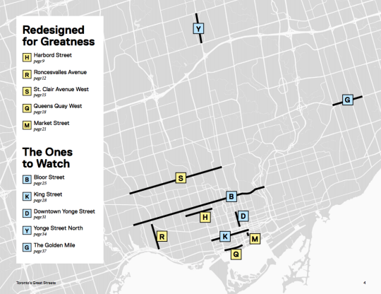
    Last week the Ryerson City Building Institute published a terrific report on Toronto’s Great Streets. It profiles five streets in the city that have been “redesigned for greatness.” They are:

    • Harbord Street (continuous bike lanes)
    • Roncesvalles Avenue (placemaking and people)
    • St. Clair Avenue West (dedicated streetcar lane)
    • Queens Quay West (public waterfront promenade)
    • Market Street (prioritized for people and patios)

    But what exactly makes a street a great one? The report describes it in this way: “They all play a key role in making the surrounding neighborhood a great place to live, work, and visit.”

    This relates closely to what the City of Toronto calls a “complete street”, which is an approach to accommodating multiple kinds of users, enhancing the local context, and determining which trade-offs to make.

    And there will always be trade-offs. I am fairly certain that all of these street redesigns were contentious at the time when they were proposed. Because at the end of the day they will never be all things to everyone.

    I remember the St. Clair West fight vividly because I moved to the neighborhood in 2009 and the dedicated streetcar lane didn’t fully open until 2010. From 2005 to 2017, streetcar ridership grew 23%. But drivers have remained grouchy.

    I now walk Market Street every single day and I agree that it’s one of the most beautiful and functional streets in the city. But the bollards are constantly getting beat up by drivers attempting to parallel park and the retail vacancy rate has not been 0% like is suggested in the report.

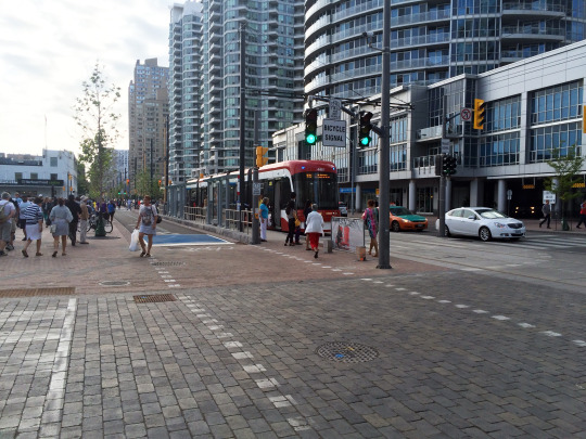
    Queens Quay West is also a magnificent street. It was a giant step forward in terms of the quality of the public realm in this region and I spend a lot of time there. But it’s of course not perfect. All of us have seen the reports of cars ending up in odd locations, including underground, along the waterfront.

    Riding your bike there can also feel like a challenging game of Frogger with all of the pedestrians that now obliviously meander back and forth across the cycling trail. I suggest riding with a good blow horn. The report rightly mentions the lack of delineation between these users.

    But cities are a living laboratory and none of these streets should now be considered static. We are fortunate to be in a position to critique levels of greatness. If anything, the map at the top of this post tells me that we need to create more greatness across the other areas of this city.

  • 10 reasons to visit Toronto right now

    https://500px.com/embed.js

    Next weekend a good friend of mine from architecture school will be visiting Toronto from Philadelphia. And I’m really excited to show him the city. (Next month it’s my turn to go to Philadelphia.)

    He’s a fellow city geek. He hasn’t been to Toronto in a number of years. And I haven’t seen him since our trip to Detroit 2 years ago.

    For those of us living and working in Toronto, there’s a lot to celebrate. Sure the Gardiner Expressway East decision didn’t go as I – as well as many other urbanists, including our Chief City Planner – had hoped. But there’s no shortage of other things to brag about.

    So here are 10 reasons to visit Toronto right now:

    1. We’ve created an entirely new business district south of Union Station called South Core. Now the region’s primary mobility hub is in the middle of the country’s most important business district, as opposed to on the edge of it. It’s a better use of infrastructure.

    2. We now have a dedicated train (the Union Pearson Express) that takes you from the country’s busiest airport directly to downtown in 25 minutes. You’ll find local retailers at the stations and a brand created by the brain behind Monocle Magazine. You can even use a smart card to ride it and our local transit system.

    3. We didn’t shut down Uber. Instead our mayor wants to create new policy that will allow these services to coexist with conventional taxi services. We don’t yet know how this will turn out, but I believe it’s a step in the right direction. It’s Toronto taking a leadership approach to innovation as opposed to trying to stomp it out.

    4. We are about to host the largest sporting event in Canadian history. The 17th Pan American Games will have double the number of athletes competing as the 2010 Winter Olympics in Vancouver.

    5. We created an entire neighborhood from scratch in order to house all of these athletes (Canary District). And I think it’s destined to become one of Toronto’s great neighborhoods. I’m saving my first visit for next weekend, so expect a follow-up post on this.

    6. We are dramatically rethinking this city’s public realm. From the plaza out front of Union Station to the new Queens Quay Boulevard along the waterfront, we are prioritizing people and creating more complete streets. It has given Toronto an entirely new urban feel.

    7. We are slowly starting to embrace our forgotten laneways and alleys through the help of organizations like The Laneway Project. And this is going to eventually lead to a further rethink of our pubic spaces and urban fabric.

    8. We continue to be one of the fastest growing cities in the world (certainly in the developed world). As a result, we are building some really exciting buildings by some of the top architects in the world. This includes everyone from Norman Foster to Frank Gehry.

    9. According to a recent report coming out of the Martin Prosperity Institute, Canada is one of the most creative and globally competitive countries in the world, as well as the most open to “ethnic and religious minorities and gay and lesbian people.”

    10. The ATC community is in the process of identifying a new, quintessentially Toronto food dish. But since we have every type of imaginable cuisine here, we’re struggling to pick just one. When you visit, you can help us identify the best and most Toronto dish.

    So there’s a lot to be excited about. I for one can’t wait for us to host the Pan Am Games, starting tomorrow. It’s a chance to show off this great city. 

    So if you’re also in town next weekend and want to geek out about cities, drop me a line.

  • Before & After: Queens Quay Boulevard

    Yesterday I spent the evening walking Toronto’s new Queens Quay Boulevard, which fully reopened this past Friday after a number of years of construction. 

    It is part of Waterfront Toronto’s revitalization efforts and represents a solid decade in the making. West 8 of Rotterdam and DTAH of Toronto won the international design competition for the central waterfront back in 2006. And this past weekend a big component of that vision was unveiled.

    But first, let’s take a look at what Queens Quay Boulevard used to be like. Here’s a Google Streetview image from 2009:

    image

    The streetcars ran in the middle of the street. Cars drove on the north and south side on both sides of the tracks. And the sidewalks were fairly small and usually at capacity during the busy summer months. It wasn’t a great street.

    Now here’s a photo that I took yesterday from that same vantage point (2015):

    image

    The street has been completely reorganized. On the north side of the streetcar tracks is where the cars now drive in both directions. On the south side of the tracks the lanes of traffic have been replaced with a 2-way bike trail (part of the Martin Goodman Trail). And on both sides the pedestrian areas have been greatly expanded. It’s now a magnificent street.

    If you haven’t yet been down to the new Queens Quay, I would encourage you to check it out on either foot or bicycle. (If you go on bicycle, let me know and I’ll join you.) 

    Toronto may have taken a giant step backwards with its recent decision on the Gardiner East, but we also took a giant step forward with the reopening of Queens Quay Boulevard.

  • Where should Toronto’s relief subway line go?

    Those of you from Toronto might be aware that the city is currently assessing the possibility of a “relief subway line” that would connect the downtown core back up to the Bloor-Danforth subway line in the form of a stretched out “U”.

    The reason this line is being called a “relief line” is that – in addition to providing local service all across downtown and its “shoulders” – it would also relieve much of the pressure that the Yonge-Bloor interchange is facing today. Instead of always having to connect at that location, passengers coming from the east and west would be able to do so sooner as a result of this new subway line (bypassing Yonge-Bloor).

    For those of you who are regular readers of ATC, you might know that I’m a big supporter of this relief line. I believe it should be our number one transit priority. It’s going to cut through areas of the city that have some of the highest population and employment densities, and so it’s an area where I think subway makes sense. The ridership would be there.

    Many people at the city also seem to agree:

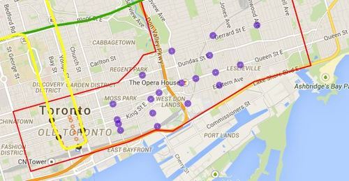
    Given that an assessment is currently underway, the city is looking for feedback from the public. One of the ways you can do that is by clicking here. The site will allow you to comment on the potential station locations (shown below using purple circles). I did it this morning and I would encourage you to do the same if you’re from Toronto.

    For clarity, this current study is only for the eastern portion of the relief line (study area is outlined in red below).

    image

    Once you’ve given this some thought, I’d love to have a discussion in the comments about where you think the relief subway line should go (or if you even think it’s a good idea in the first place).

    My initial thought is that it should connect into King station, run along King Street East, merge with Queen Street East near the Don Valley, go through Riverside and Leslieville, and then start making its way north to Danforth Avenue.

    My reasons are as follows:

    • King Street East is the most vibrant pedestrian street on the east side of downtown. There isn’t enough commercial activity further south.
    • King Street would allow it to eventually cut right through the Financial District when it heads westward.
    • The connection to Union station (for GO Transit, VIA Rail, and the Union-Pearson Express Train) would be manageable from King Street. Plus, SmartTrack may feed directly into Union.
    • King Street is roughly the midpoint between Queen Street and Lakeshore Boulevard. And if you place it too far south, it would take away from the proposed Queen’s Quay LRT line.
    • Having it merge into Queen Street near the Don Valley would allow it to service both Regent Park to the north, as well as the West Don Lands neighborhood to the south. It would also allow for a connection to a Cherry Street LRT line servicing the future Portlands neighborhood.
    • Queen & Broadview is emerging as a major node with a significant amount of density in the pipeline. And further north, Dundas & Carlaw is similarly seeing a lot of intensification.

    But I may have missed a few things. These are just my thoughts. What are yours?

  • Merry Christmas everyone

    image

    Today is Christmas Day. I hope that you are all having a wonderful day and spending it with family and friends. That is exactly what I’m doing here in Toronto.

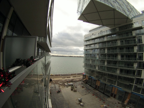
    It’s certainly nice to have a bit of downtime. I’ve been playing around with my new GoPro (see above photo), which had been sitting unopened on my shelf for the past few weeks.

    The photo above was taken at the Pier 27 condos. It’s still very much a construction zone. The area at grade in the photo will be a linear public park that connects the main street to the waterfront. I’m looking forward to seeing it come together.

    Have a great day everyone 🙂

  • Pre-delivering new homes

    image

    Today was my mother’s PDI for her new condo. For those of you who aren’t in the industry, a PDI is a “pre-delivery inspection” that happens about a week or two before you take occupancy of a new home. It’s basically a time for you to identify all the mistakes that the construction team has made and have them (hopefully) correct them before you actually move in.

    But for someone like my mother who is making the move from a house that she’s lived in for decades, a PDI is actually something much more significant: It’s the first time she saw her new “home.” And a home is something much different than just a house or a condo – it has emotional significance.

    It’s going to be an adjustment for her. One of the first things she did was open up the oven to see if she could fit her Christmas turkey in it. But in the end, I have no doubt that she’s going to love her new home. As I’ve mentioned before, people often overestimate the potential risks of change. But never be afraid to give up the good to go for the great.

  • Pier 27 and transparency in the real estate industry

    One of my favorite development projects going up in Toronto right now is the Pier 27 complex at the base of Yonge Street.

    What I love about it is that it’s trying something different. The two sky bridges that sit atop the two phases—currently under construction—are going to create a remarkable new focal point along the waterfront. It’s not just another condo.

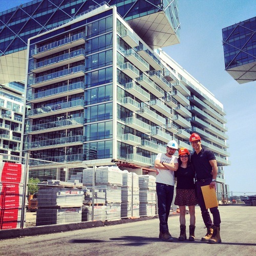
    And as I watch the buildings go up, I’ve also been impressed by the materials used on the project. In particular the curtain wall (glazing) system used on the eastern most buildings. It’s a clear glass installation with white accent pieces. It’s beautiful. Here are a few photos.

    But as much as I love this project, it’s been slow moving. This project, like many others in the city, has been subject to a number of delays. They went to market in 2006-2007 and occupancy isn’t expected until next year—a good 7 years later.

    But more than the issue of time, my real concern is the lack of transparency. Why was it delayed? Were sales slow? Were there dewatering issues being on reclaimed land along the waterfront? Was the soil contaminated? As a consumer, it’s frustrating being in the dark.

    I do, however, acknowledge that this is a larger issue facing the real estate industry. We’re certainly not known for radical transparency. We’re a closed and insular industry. But over time I do believe that will change. It’s inevitable. And the best thing you can do today—as an organization or as an individual—is to embrace it.

    Full disclosure: I have a vested interest in this project and I’m currently having a fight with the developer over a small amendment I would like to make to the agreement of purchase and sale. They have been unwilling to cooperate.