Daily insights for city builders, delivered every morning at 6 AM ET. I’m Brandon Donnelly — a Toronto-based real estate developer and founder of Globizen. I’ve been writing here since 2013.

Tag: queen street

  • The Shinola Hotel, Detroit

    Hotels play such an interesting role within cities. They are public-facing in a way that many other uses are not and they invite a mixing of different people – everyone from transients to locals. It is therefore no surprise that they can serve a variety of different roles. They can be cultural hubs. But they can also be places in which to misbehave.

    When the Drake Hotel opened up on the west side of downtown Toronto in 2004, I remember it feeling far out. It was on the edge of that which was interesting at the time. But it quickly anchored West Queen West with its cultural and nightlife offerings. And today, we could be about to see the exact same story repeat itself in the east end with the new Broadview Hotel.

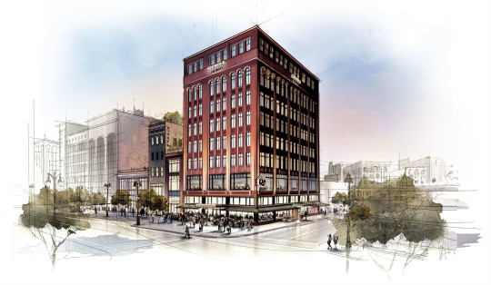
    It’s for these reasons that I was both excited and curious to learn that Bedrock (real estate company) and Shinola are in the midst of launching a new boutique hotel concept in Detroit. It is called The Shinola Hotel. It will be located at 1400 Woodward Avenue. And it will be all about the city of Detroit. They expect it to open sometime in the fall of 2018.

    What I am about to say may be an availability bias talking, but there seems to be a push by many companies into the hotel space. In 2015, Equinox Fitness announced that it would be opening its first hotel in 2018 at Hudson Yards in New York. And just last month furniture retailer West Elm announced that it would be opening a first set of hotels in both Savannah and Detroit. (Go Detroit!)

    West Elm sells furniture. Equinox operates gyms. And Shinola makes and sells watches, bikes, and leather goods. But all of them are now in the hotel space. What other new hotel brands have I missed?

    Image: Shinola

  • A Love Letter to the Great Lakes

    This week, the first ever international street art festival will be taking place in Toronto. It’s called A Love Letter to the Great Lakes and it is running from June 20 to June 25, 2016.

    The goal of the festival is to use public works of art to get people thinking about our water resources and, more specifically, about the Great Lakes. Together, these Lakes represent 20% of the world’s fresh surface water.

    So this week, 21 local and international artists will be painting giant murals in 3 different areas of the city: Queen & Ossington, Queen & Spadina, and at the mouth of the Don River.

    The collaborators for the event include Tre Packard (Pangeaseed Foundation), Jason Botkin (A Love Letter to the Great Lakes, En Masse), Jaqueline West (Herman & Audrey), developer Jeff Hull (Hullmark) and Devon Ostrum (Friends of the Pan Am).

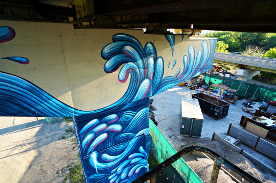
    Below is one of the works already in progress. It’s by Jason Botkin and it’s located on one of the bents of the Gardiner Expressway East at the mouth of the Don River.

    image

    This event caught my attention for 3 reasons.

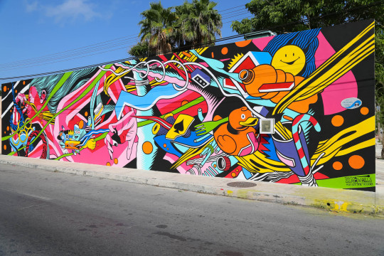
    First, I think the city is going to be left with some rad looking murals. Here is one from a similar event in Cozumel, Mexico called Sea Walls: Murals for Oceans in Cozumel:

    image

    Second, like many others, I care deeply about the environment. But until we put in place the right economic incentives / disincentives, we need all the awareness building that we can get.

    Third, seeing Jeff Hull on the list of collaborators reminded me that there’s a new breed of real estate developers emerging in our cities. The big bad developer is sometimes (often?) thought to be greedy and insensitive to local communities. But I think the next generation sees itself quite differently. They see themselves more as city and community builders.

    So if you’re in Toronto this week, get on your bike and head over to one or more of the mural sites. Tweet me if you decide to go and maybe we can connect.

  • Building Toronto Tomorrow

    I’m going to be speaking on a panel on May 3rd, here in Toronto, called Building T.O. Tomorrow. The topic is the future of this city.

    It is being put on by the good folks at BuzzBuzzHome and it will be held in the lobby of Allied’s new Queen-Richmond Centre (134 Peter Street). If you haven’t yet been to this building, that alone makes attending worthwhile.

    Here’s the event poster:

    If you’d like to attend, make sure you RSVP to aleks@buzzbuzzhome.com.

    On a largely unrelated note, I recently picked up the handlebar bicycle mount for my GoPro and I’m looking for some fellow city geeks who would like to ride around the city and film some – potentially cool – videos.

    I find that being on a bike is one of the best ways to experience a city (at least the cities that are actually bikeable). So I’m hoping some of that magic will translate into video. If that sounds at all interesting, drop me a line.

  • Where should Toronto’s relief subway line go?

    Those of you from Toronto might be aware that the city is currently assessing the possibility of a “relief subway line” that would connect the downtown core back up to the Bloor-Danforth subway line in the form of a stretched out “U”.

    The reason this line is being called a “relief line” is that – in addition to providing local service all across downtown and its “shoulders” – it would also relieve much of the pressure that the Yonge-Bloor interchange is facing today. Instead of always having to connect at that location, passengers coming from the east and west would be able to do so sooner as a result of this new subway line (bypassing Yonge-Bloor).

    For those of you who are regular readers of ATC, you might know that I’m a big supporter of this relief line. I believe it should be our number one transit priority. It’s going to cut through areas of the city that have some of the highest population and employment densities, and so it’s an area where I think subway makes sense. The ridership would be there.

    Many people at the city also seem to agree:

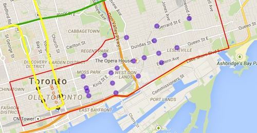
    Given that an assessment is currently underway, the city is looking for feedback from the public. One of the ways you can do that is by clicking here. The site will allow you to comment on the potential station locations (shown below using purple circles). I did it this morning and I would encourage you to do the same if you’re from Toronto.

    For clarity, this current study is only for the eastern portion of the relief line (study area is outlined in red below).

    image

    Once you’ve given this some thought, I’d love to have a discussion in the comments about where you think the relief subway line should go (or if you even think it’s a good idea in the first place).

    My initial thought is that it should connect into King station, run along King Street East, merge with Queen Street East near the Don Valley, go through Riverside and Leslieville, and then start making its way north to Danforth Avenue.

    My reasons are as follows:

    • King Street East is the most vibrant pedestrian street on the east side of downtown. There isn’t enough commercial activity further south.
    • King Street would allow it to eventually cut right through the Financial District when it heads westward.
    • The connection to Union station (for GO Transit, VIA Rail, and the Union-Pearson Express Train) would be manageable from King Street. Plus, SmartTrack may feed directly into Union.
    • King Street is roughly the midpoint between Queen Street and Lakeshore Boulevard. And if you place it too far south, it would take away from the proposed Queen’s Quay LRT line.
    • Having it merge into Queen Street near the Don Valley would allow it to service both Regent Park to the north, as well as the West Don Lands neighborhood to the south. It would also allow for a connection to a Cherry Street LRT line servicing the future Portlands neighborhood.
    • Queen & Broadview is emerging as a major node with a significant amount of density in the pipeline. And further north, Dundas & Carlaw is similarly seeing a lot of intensification.

    But I may have missed a few things. These are just my thoughts. What are yours?

  • A brief history of T. Eaton Co.

    image

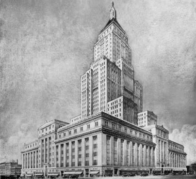
    I was out last night near Yonge and College for a friend’s going away party and the topic of the College Park building came up (originally an Eaton’s department store). We talked about how in the 1920s it was planned as a 38-storey Art Deco tower (see above photo), but that the Great Depression forced Eaton’s to scale back their plans. They ended up building a 7-storey building, albeit an impressive one.

    Then today, thinking about that discussion, I became curious about the story of Eaton’s. Where exactly did it start and how did they get to a point where they were planning the largest retail and office complex in the world?

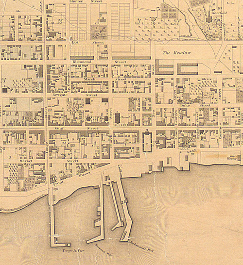
    Well, as many of you probably know or can guess, the first Eaton’s store was opened where the Toronto Eaton Centre mall currently sits today. The exact address was 178 Yonge Street, which is just north of Queen Street. But what was interesting about this location is that, at the time, it was considered to be far removed from Toronto’s center of fashion and retail. That was King Street East. Below is a map from 1842.

    image

    In 1869 when Timothy Eaton opened his first store, the heart of Toronto was what is today known as Old Town (although most people would probably just refer to it either as King East or as the St. Lawrence Market). People shopped along King Street between Yonge and Jarvis, and Queen Street probably would have felt out of the way.

    image

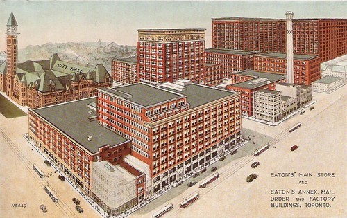
    But Eaton’s succeeded at Yonge & Queen, along with rival store Simpson’s, and retailing shifted northward. With Eaton’s College Street, the company was once again looking north. In fact, they wanted to move their entire operation from Queen Street up to College Street, and they even tried to get Simpson’s department store to do the same (somebody clearly understood agglomeration economies).

    But since the full build out of Eaton’s College Street never actually happened, both stores were kept in operation and a customer shuttle bus was run between the two of them (until the Yonge subway line opened up in the 1950s). With the opening of the Toronto Eaton Centre mall in the 1970s, Eaton’s closed both Queen and College Street locations, and consolidated operations near Dundas Street.

    In 1999, after 130 years of operation, the company went bankrupt.

    What I find interesting about this story is that it speaks to how dominant the department store business model was at the time and how it was shaping the city around it. If Eaton’s had achieved its vision for the corner of Yonge & College, Toronto might look a lot different today. Perhaps we’d all be shopping for fashion along College Street.

  • Every street can’t be everything to everyone

    Yesterday I spoke about why Toronto shouldn’t be so quick to dismiss streetcars and light rail. Today, I’d like to talk about some of the hard decisions we need to face if we really want to get our city moving.

    Toronto is a city of neighborhoods and small main streets–at least in the areas where our streetcars live. Streets such as King and Queen are only 4 lanes. And the problem we’re facing is that we’re trying to accommodate every single use case on them: cars, on-street parking, cyclists and streetcars. But in doing so, we’ve made the experience terrible for everybody. Streetcars move at a snail’s pace, drivers are frustrated by the lumbering streetcars, cyclists fear for their life driving by parked cars (doors can swing open at any time), and so on.

    And with the rise of downtown shoulder neighborhoods such as Liberty Village, King West, the Distillery District and the soon to be complete West Don Lands, the strain on our east-west corridors is only going to get worse–much worse, in fact. Already the King streetcar is the busiest streetcar route in the city, moving almost 60,000 people per day. That’s more than the (under utilized) Sheppard subway line.

    What I hope is clear to the ATC community though, is that the answer isn’t uniformly the car. We can’t have every single resident from Parkdale to Leslieville hopping into their car and driving downtown to their office at Yonge & King. It ain’t going to work. And so we’re going to need to make some difficult decisions about how we’re going to get our city moving on the backbone of transit.

    Sure the downtown relief subway line (screw the politics I’m attaching it to downtown) would be the ideal solution to connecting our emerging shoulder neighborhoods, but that’s not going to happen overnight. And so how do we improve the efficiency of what we already have? First, we need to accept the fact that every street isn’t going to be everything to everyone at all times. We need to choose who we want to optimize for.

    So here’s an idea that’s been floated many times before but never acted upon: let’s get rid of cars on King St and Queen St in the core during rush hour.

    This would give our streetcars the room to efficiently move people across downtown, minimizing the dreaded “bunching up” that occurs as a result of traffic congestion. It would make transit a reliable choice and there are ways to pilot it. But let’s be clear: this is not about being anti-car. It’s about optimizing uses and getting people moving. Cars would continue to get priority on Richmond St and Adelaide St, and transit riders (as well cyclists) would get priority on King and Queen.

    Of course, the Rob Ford viewpoint would say that we should be optimizing all streets for cars and getting the streetcars completely out of the way. But if that’s the approach we want to take, then we’re building the wrong kind of city. We shouldn’t be focused on intensifying and creating new inner city neighborhoods, because that only tips the scale in favor of transit. Instead, we should be focused on decentralization.

    But that’s what not we’re doing. We’re intensifying our city to the point that we’re now faced with a number of difficult–yet enviable–decisions about how we’re going to live and how we’re going to move around in the future. We’re a city in transition.

    Our mission here should be to figure out how to move people around the city as efficiently possible. Let’s put politics aside and recognize that time is one of our most precious resources. And when we put people in lumbering streetcars and debilitating traffic jams, we’re completely squandering that resource. It hurts productivity and it hurts our overall prosperity as a global city.

    There’s a place for subways, streetcars, buses, bikes and cars in our city. So let’s just get on with making them all work.