Daily insights for city builders, delivered every morning at 6 AM ET. I’m Brandon Donnelly — a Toronto-based real estate developer and founder of Globizen. I’ve been writing here since 2013.

Tag: public realm

  • Toronto’s discontinuous sidewalks

    Dave LeBlanc recently published an article in the Globe and Mail called, “How wide is your sidewalk?” And in it, he links to this sidewalk map of Toronto (pictured above), which uses open data from the city to plot sidewalk widths.

    It was originally intended as a map of where social distancing is possible (oh, how far we’ve come), but today it serves as a really interesting way of looking at the city. What it makes clear to me is that we could use a lot more sidewalk, and that too many areas of the city have a discontinuous public realm.

    Sometimes there’s very little that can be done until an adjacent property gets redeveloped. And when this does happen, the city will demand pedestrian widenings. But in other cases, there are solutions that could be implemented today, without private participation.

    So I sure hope that someone is looking at a map like this and trying to come up with holistic solutions for making Toronto a more walkable and more pedestrian-friendly city.

    Note: Sometimes a narrow sidewalk does not necessarily equal an inhospitable street. I mean, look at this example.

  • Some Sicilian inspiration for #KioskTO

    I have written before about how Lisbon’s kiosks both anchor and beautify the city’s public spaces. I have also written about how Toronto should have something similar — #KioskTO anyone?

    Some of you might remember an expanded street food program that the city piloted many years ago. It was a complete and utter failure. In my opinion (and from what I can remember), it was too heavily regulated. The food ended up being far too expensive and, frankly, none of it was very good.

    That’s not how this should work. The entire point of things like food trucks and street kiosks is that they are cheaper alternatives to a conventional physical location. You can also more easily place them in locations where demand is being underserved.

    The one pictured here is in Catania, Sicily. I carried my beer over from a panini shop down the street and then we ordered three espressos for a total of 2€. I tried to sit on a crate they had lying on the ground but I ended up breaking it. Sorry, guys. So we stood instead. It was all rather civilized.

    Let entrepreneurs figure out what to sell and where. It will be a boon for both small business and for our public spaces.

    P.S. I tweeted this photo out earlier today and it elicited a good discussion on Twitter. Toronto wants this.

  • Learning from Lisbon

    This happened earlier in the week:

    And it got me thinking about how much I love Lisbon:

    But the important story here is that these tweets made it abundantly clear to me that (1) people from all over want far more from their parks and public spaces and that (2) Lisbon’s kiosks are a truly beloved urban feature.

    I’m putting this all out there because I received a ton of inbounds following these tweets, and I would love to find a way to execute on the kiosk idea that I outlined in the above twitter thread. So if you’d like to help, please continue to get in touch.

  • Guideway and Greenway

    Just northwest of the intersection of Lansdowne Avenue and Dupont Street here in Toronto, there is something known as the Davenport Diamond. It refers to the intersection of two rail lines. Going north-south is the Barrie GO corridor (regional rail service). And going east-west is a set of Canadian Pacific Railway tracks. The problem with this Diamond is that it is one of the busiest train intersections in North America and these two corridors meet at grade. So it is a problem for service levels on this corridor.

    To address this bottleneck, Metrolinx has been working on a project called the Davenport Diamond Guideway and Greenway. First and foremost, what it will do is elevate the Barrie GO corridor between Bloor Street in the south and Davenport Road in the north, allowing trains to pass over the CP tracks (rail over rail), as well as over streets like Wallace Avenue (rail over road). Metrolinx expects to have this guideway complete by spring 2023 and it will be a good thing for rail service levels across this region. Construction activity is already happening.

    But the other thing this guideway does is open up the ground (literally) for a new greenway. Metrolinx is calling this the public realm component of the project, and it expects to procure this work separately, as well as complete it only after the guideway is operational. The ETA for this is 2024. However, a design was completed for the greenway back in 2018. It was completed by gh3 — one of my favorite architecture firms in the city. And it is my understanding that this original design will be the foundation for the public realm design. Or at least, I hope it will.

    If you haven’t yet seen gh3’s design, you can check it out over here.

    Image: gh3

  • Would wider sidewalks induce demand?

    One of the debates that is happening in cities all around the world right now is about whether or not it makes sense to redistribute public space in order to help with current social distancing measures. We are all being told to stay at home as much as possible, but as we venture out for food and/or sanity walks, many have started noticing that a lot of our sidewalks are in fact too small if you’re trying to stay 2m away from other humans. So with vehicular traffic way down, the question becomes: Should we start borrowing some of that space for pedestrians?

    Here in Toronto the official position is no. Closing down streets and lanes to car traffic is usually referred to as creating an “open street.” And the intent of these open streets is typically to bring people together for public life, which, of course, is the exact opposite of what we’re trying to do right now. What this implies, however, is that there’s a belief that additional space for pedestrians would induce demand, similar to what is believed to happen when you add additional lanes on a highway.

    Lewis Mumford probably had it best when he allegedly said, “Adding highway lanes to deal with traffic congestion is like loosening your belt to cure obesity.” So on the one hand, if you believe that more lanes doesn’t solve traffic congestion, you might also be inclined to believe that more and bigger sidewalks isn’t going to dampen the anxiety we currently feel when other humans get anywhere near us. The additional space would simply get filled with more bodies.

    But maybe you could argue that this is a little bit of a different situation. We’re in a global pandemic for God’s sake and most of us have the better sense to stay home unless it’s absolutely necessary. Perhaps in this case, demand would not increase and the greater supply would simply better serve the demand that is already there. Perhaps. I don’t have a strong stance on this, but I’m fairly certain that technology could help with this decision.

    What do you think?

    Photo by Jason Blackeye on Unsplash

  • Portuguese pavement

    One of the defining characteristics of Portuguese cities is the stone paving that is used in many or most pedestrian spaces. In European Portuguese, it is called calçada portuguesa. Above is a photo — that I didn’t take — of Rossio Square is Lisbon.

    This craft was also exported to Portugal’s former colonies, including Rio de Janeiro, Macau, and Luanda. Supposedly, the Portuguese used to load up their boats with limestone in order to weigh them down and make them stable before they set sail. And that’s, at least partially, the reason why this tradition ended up traveling.

    They’re dangerously slick when wet — particularly in a hilly city like Lisbon — but they sure are beautiful. Here’s a short video talking about the tradition in Macau. It’s an interesting example because the Chinese ended up adding their own touches.

    Click here if you can’t see it below.

    Photo by Alex Paganelli on Unsplash

  • Inverted podium

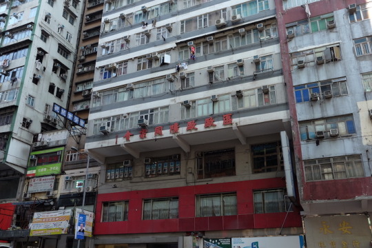
    One of the things that I noticed yesterday morning on my walkabout from Wan Chai to Causeway Bay is that some/many of the buildings in Hong Kong actually step-in, as opposed to step-back, once you get above the base or “podium.” In many cases the step-in comes out almost to the curb line.

    (Note how the reference point is the public realm. You step back from it or you step into it.)

    Here is an example:

    image

    Setbacks and step-backs are longstanding urban design tools because they can allow more light to reach the street and they can visually break-up the mass of a building and establish clear datum lines, among other things.

    We’re obsessed with them in Toronto because everyone is always trying to hide building height. But in Hong Kong, space is such a rare commodity that it seems to be about filling in every available inch.

    I posted this remark on Twitter yesterday and it was suggested that some of these step-ins may have been the result of additions made after the fact. They seemed original to me, but whatever the case may be, they are an existing condition that I have started calling the inverted podium.

  • Celebrate the sidewalk (at Yonge + St. Clair)

    I have two quick announcements to make regarding Yonge + St. Clair in midtown Toronto.

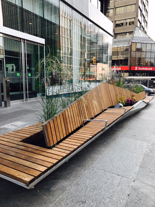
    The first is that Slate has just unveiled a new “ravine bench” at the northeast corner of the intersection. 

    Here’s a photo:

    And here’s another photo with people sitting in it. #SitTO

    Designed by Gensler (the same firm behind the renovation of 2 St. Clair Ave East), the design is all about celebrating both the sidewalk/public realm and the extraordinary ravines that cut through the area. Some people may not even be aware of these natural features, so perhaps this bench will help with that.

    The second announcement is the launch of our Yonge + St. Clair Pop-up Store at 1470 Yonge Street. I know this is short notice, but the launch party is on Thursday, September 21 from 6 – 10pm (drop in whenever). That’s tonight if you’re reading this post via email subscription.

    At the party we’ll be introducing 8 exclusive t-shirt designs from Toronto artist, Lucas Young. All of the tees will be screen-printed for you right on the spot and 50% of all proceeds from the opening night will be going to The Canadian Cancer Society. 

    Wine, beer, and snacks will be available. If you come find me at the party, I’ll give you some drink tickets. So if you’re around on Thursday night, come by for some drinks, a Toronto tee, and to check out the new ravine bench on Yonge Street.

  • Project: Under Gardiner — Re-imagining Toronto’s urban infrastructure

    image

    If you’ve been reading this blog since the summer, you might remember that there was a period of time where I wrote incessantly about the removal of the eastern portion of Toronto’s elevated Gardiner Expressway.

    Ultimately City Council didn’t vote the way I believe we should have. But I remain hopeful that somehow we will manage to do the right thing and replace it with a surface boulevard. Now – before the east waterfront gets developed – is the right time to make that happen.

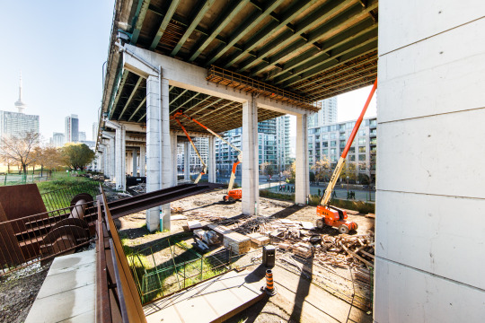
    However, the western portion of the Gardiner Expressway is a different story. The adjacent area is already developed and it is unlikely that this highway is going anywhere any time soon. So for the foreseeable future, we are stuck with it.

    And if we are stuck with it then we should make the absolute best of it – even celebrate it. Which is why Toronto is buzzing right now with the news that a 1.75 km stretch under the western portion of the Gardiner Expressway will be remade into a vibrant public space by 2017. This is thanks to a generous $25 million private donation. (Is that enough money?)

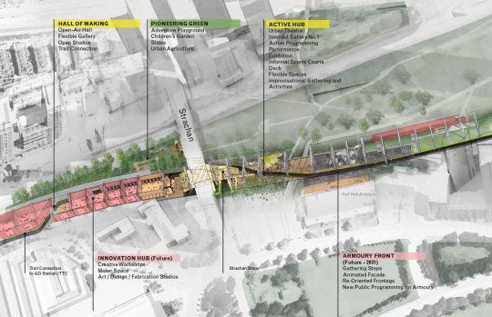
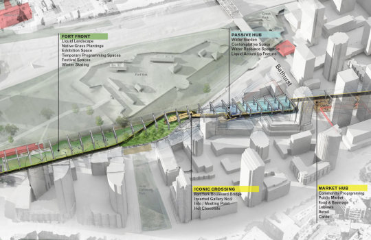
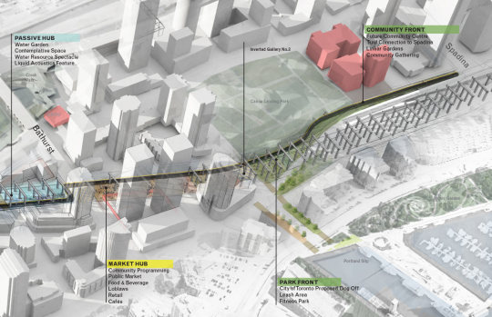
    Here’s the overall programming strategy, going from west to east (via undergardiner.com):

    imageimageimage

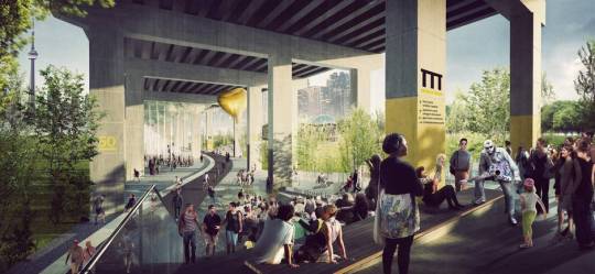
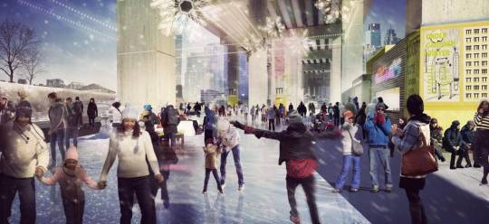
    And here are two renderings:

    imageimage

    The first phase is expected to run from Strachan Avenue in the west all the way to Spadina Avenue in the east. That is what is shown above.

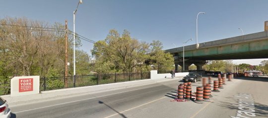
    Two key elements include a grand stair at Strachan Avenue, which looks like this today (via Google Streetview):

    image

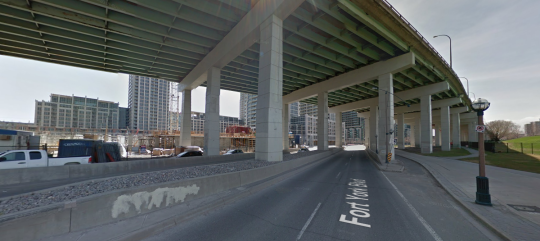
    And a pedestrian bridge over Fort York Boulevard, which looks like this today:

    image

    All of this doesn’t change my opinion of the Gardiner East, but I do believe that this is an incredibly exciting opportunity for the city. Today the space under the Gardiner is a void in our public realm.

    I also think it could be quite interesting to have these two opposing urban conditions along the central waterfront. A linear underpass park in the west and an open air boulevard in the east.

    It’s also exciting to see private money step up. It goes to show you that there is no shortage of passionate city builders in this town.

    Top image courtesy of Harry Choi Photography.

  • Q&A on reimagining public spaces

    I received an email from an ATC reader yesterday who is working on a publication about reimagining public spaces in Toronto. She sent me a few questions and specifically wanted to talk about the Yonge Redux project, which I wrote about a month ago. After I responded to her questions, I figured I should just share them publicly. So here they are:

    How would citizens from different age groups benefit from the Yonge Redux project?

    I would bet you that this stretch of Yonge Street experiences more pedestrian traffic than it does car traffic. And yet we’ve allocated space in the opposite direction: cars have more space than pedestrians do. So what this project is really about is reallocating the street, or public right-of-way, so that the dominant uses are actually prioritized through urban design. It doesn’t need to be more complicated than that. Ultimately, this will benefit people both young and old.

    Do you know what kind of professionals are needed to complete a project like this?

    You’d need an architect/designer – one who is awesome at landscape/urban design work. gh3 here in the city comes to mind as a firm I like, if you want an example. You’d need a bunch of engineers to deal with stormwater management and other infrastructure items. You’d likely need a transportation/traffic consultant to assess traffic flows in the area and prove that this project won’t cause the entire city to come to a grinding halt (it won’t). You would need someone to manage the day-to-day of the entire project. And this is just naming a few of the professionals/consultants that you’d probably end up needing.

    You’d also have to work closely with the city, the local councillor, and the local community. It’s inevitable that some of the businesses will worry about the loss of potential customers – so that would need to be worked through.

    What are some areas in Toronto that, in your opinion, need reimagining in the next few years?

    My feeling is that Toronto is still at the early stages of this shift towards better public spaces and a better public realm. But in many ways, projects like Yonge Redux are much easier sells compared to the other areas that could use a face lift. Yonge Street is already urban and pedestrian friendly. The real challenge is going to be dealing with the areas outside of the core – most of which, frankly, aren’t that welcoming to pedestrians and aren’t all that urban. What do we do with those? And do the local communities even want them transformed? They’re going to be much harder to reimagine (though I’m not saying we won’t be able to do it).

    Where do you see the future of Toronto’s public spaces in the next 50 years?

    All signs point to a more dense, more urban, and more transit-oriented city. With that shift, we’re going to increasingly realize the importance of incredible public spaces. So if we continue down this path, I reckon our public spaces will only get better. I’m optimistic about the future.

    How would you personally approach a project like this?

    My understanding is that this project has legs. It just has to work through the city bureaucracy at this point. Jennifer Keesmaat supports it.