Daily insights for city builders, delivered every morning at 6 AM ET. I’m Brandon Donnelly — a Toronto-based real estate developer and founder of Globizen. I’ve been writing here since 2013.
The Pembina Institute has just published this report looking at the impact that road pricing could have on the various income groups across the Greater Toronto and Hamilton Area. One of the common arguments against road pricing is that it disproportionately impacts lower income folks.
The study specifically looks at the proposal that Toronto put forward in 2016 to apply a flat congestion charge of $2 on the two highways leading into downtown. The proposal was ultimately rejected by the province, but I thought it was a step in the right direction. In my opinion, a dynamic road pricing model, similar to what is used in Singapore, would be preferable.
The report concludes by arguing that road/mobility pricing is destined to become a tool in this region if we are serious about managing congestion. However, they also note that it must coincide with a strong and sustained investment in transit. And I would agree with that. That’s one of the reasons why you do this – to fund transit.
I was speaking with a friend this morning and he told me that he had a Pavlovian association between me and laneways. That made me happy.
If you’re a regular reader of this blog, you’ve heard me go on and on about the great potential of laneways and laneway housing (accessory dwelling units) in Toronto, as well as in other cities around the world.
The report is obviously about Toronto, but there’s no reason that the lessons and ideas won’t also apply to your city. So I would encourage you to give it a read.
For those of you who have emailed me about my own laneway house, the project is still on hold. And it will likely remain that way until the city becomes a bit more accepting of this housing typology. Hopefully that will happen soon.
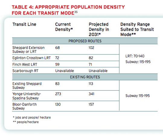
Back in 2011, the The Pembina Institute published a report called, Building transit where we need it. And in it they quite clearly outlined the population densities that are needed to make various types of transit investment cost effective.
For subway they specify a minimum population density of 115 people per hectare and for light rail (LRT) they specify a minimum population density of 70 people per hectare.
And the reason for this is because there’s a strong correlation between population density (i.e. land use) and transit ridership. The two go hand in hand and should not be decoupled. If population densities are too low (as they are, for example, along the Sheppard subway line here in Toronto), people don’t take transit. They drive.
Here’s a chart from the report showing the current and projected population densities for Toronto’s existing and proposed routes (keep in mind this is from 2011).
So what does this chart tell us?
Subways don’t make a lot of sense in many parts of the city. LRT will do just fine.
The Sheppard subway line is an under-utilized asset. Even by 2031 we’ll barely be reaching the requisite population densities.
The Bloor-Danforth corridor could use more intensification.
Unfortunately, transit decisions are often made based on politics instead of data. And that results in subways in places that don’t make a lot of sense. That’s unfortunate because it means less riders, less revenue, and more subsidies.
The other challenge with running subways through low density neighborhoods is that it then creates tension when the city and developers go to intensify those neighborhoods through transit-oriented development. (See #DensityCreep.)
But if we’re going to be fiscally irresponsible about where we deploy our transit capital, the least we could do is upzone the surrounding areas and impose minimum population densities.
In fact, here’s what I think we should do: Land use should be bundled with the transit decision.
Instead of asking where the subway station should go, we should be asking where the subway station should go and all the density needed to bring the area up to a certain minimum population density. And if that second criteria for whatever reason can’t be met, then we don’t build the line.
I wonder if we framed the question in this way if it would change where subway lines get approved. What do you think?
Earlier this month, the Royal Bank of Canada and the Pembina Institute co-published a report on Toronto’s housing market called “Priced Out”. The overarching argument is that homebuyers in the Greater Toronto Area (GTA) are being “priced out” of the areas in which they really want to live, which happen to be walkable and transit-oriented neighborhoods.
In fact, according to their research, 80% of residents in the GTA would be willing to sacrifice space (size of house and yard) if it meant they could live in a more walkable and urban neighborhood. But at the same time, more than 70% of GTA residents say that they live where they do because of affordability reasons, not because of actual preference. This, of course, isn’t new. It’s the whole “drive to affordability” notion—just keep driving until you can afford the housing.
Overall though, the report does reinforce a macro tend that I’ve discussed many times here at Architect This City. People are returning to cities in droves (or would at least like to, if they can afford it).
If you’re interested, the report also has some good data on Toronto and Canada’s housing markets.
Here’s how average home prices in Canada trended between 1980 and 2012. Vancouver became a total outlier starting in the early 90s (thanks Hong Kong).
And here’s a look at housing completions (so new construction) by product type in the Greater Toronto Area. Note how apartments/condos surpassed single-detached houses in and around 2008.