Daily insights for city builders, delivered every morning at 6 AM ET. I’m Brandon Donnelly — a Toronto-based real estate developer and founder of Globizen. I’ve been writing here since 2013.

Tag: new zealand

  • BC now allows single egress stair buildings up to 6 storeys

    The province of British Columbia made the following announcement this week:

    The Province has updated the BCBC to remove the [building] code requirement for a second egress, or exit, stairwell per floor in buildings up to six storeys. This change will make it possible to build housing projects on smaller lots and in different configurations, while allowing more flexibility for multi-bedroom apartments, more density within areas of transit-oriented developments and the potential to improve energy efficiency in buildings. Previously, the BCBC called for at least two egress stairwells in buildings three storeys and higher.

    This is meaningful progress. And BC is the leading the way in Canada. But from a global perspective, we are not leading the way. This is us catching up.

    As part of this building code change, the province commissioned a report on single egress stair building designs. In this report, they looked at various jurisdictions from around the world:

    Their non-exhaustive findings:

    There are at least 30 jurisdictions with SES building design requirements that permit midrise buildings with a building height of at least 5 or 6 storeys. In addition, the Center for Building in North America (www.centerforbuilding.org) reports that 8 US states have passed legislation into law, or are reviewing possible options for doing so, to allow larger SES buildings when their Building Code is next revised. In most cases these revisions are intended to allow SES buildings of up to 6 storeys.

    For example, Seattle already allows up to 6 storeys. Belgium, New Zealand, and Australia allow up to 9 storeys (driven by a maximum height in meters). And Finland allows up to 18 storeys, according to the report.

    Though keep in mind that building codes are complicated and often have frustrating gray areas. There may be other requirements that need to be met in order to achieve these heights.

    It’s great to see BC making these moves. Now watch for other provinces to follow suit.

  • Density lowers infrastructure costs

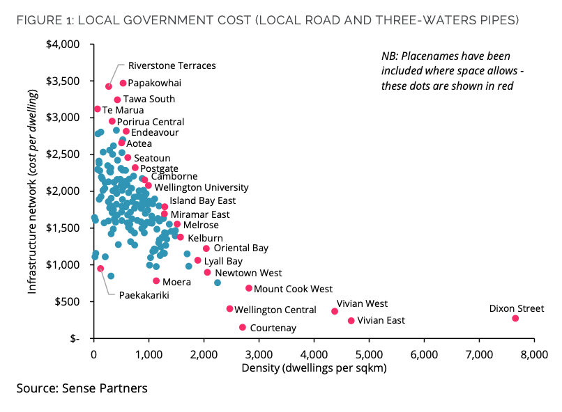
    This is an important chart from a recent study commissioned by Greater Wellington, New Zealand. The study looks at the cost benefits of urban intensification and the above chart shows the relationship been density and infrastructure costs. For this study, they specifically looked at the costs that local governments face in providing road, public bus transport, and “three-waters infrastructure.” I hadn’t heard this latter term before, but it refers to drinking water, wastewater, and stormwater.

    What they obviously found was that there are real economies to higher densities. More density lowers the per dwelling cost of delivering infrastructure. In the case of three-waters infrastructure, it doesn’t even really matter if you’re proximate to reservoirs or treatment plants. The bulk of the cost lies in the local connection pipes. So what matters most is how many dwellings you can service off of the main lines — even if these lines need to be upsized.

    The goal of this study is to enable more support for smart growth within the Wellington region:

    Regional councillor Thomas Nash says the report should give councils confidence to press on with plans that support compact mixed-use development in and around city centres and connected by high quality public transport. 

    “Regional growth needs to be smart growth. This report clearly shows that the best bang for our buck is to focus on upgrading existing water, public transport and local roading infrastructure so that we can build better quality, compact residential form, with improved amenities within our cities and towns,” Cr Nash says.

    Of course, this doesn’t just apply to Wellington. Every city should read the study.

  • The Local Project

    Regular readers of this blog will know that I am huge fan of the YouTube channel Never Too Small. I have seen most of their episodes and I like to tell people about it even when it is only remotely related to the conversation at hand.

    I love the urbanity of it all. There is just something so satisfying about turning constrained spaces into homes that are both beautiful and functional. It also makes you question how much space you really need.

    But if constraints aren’t your thing, and you’d like to see a wider variety of homes, another great channel to check out is The Local Project. The homes — which are all in Australia and New Zealand — are equally as beautiful, but tend to be more, uh, extensive. See above video.

    What are some other channels worth checking out? It seems to me like Canada needs something similar to The Local Project. Maybe it already exists.

  • New Zealand just abolished single-family zoning (for the most part)

    New Zealand has been in the news lately for sweeping housing legislation that effectively abolishes single-family zoning throughout most of Auckland, Hamilton, Tauranga, Wellington, and Christchurch.

    But before I get into how this will all work, here’s a bit of background from an article that Matt Gurney wrote talking about Toronto’s inability to build affordable housing and create safe streets:

    Now it’s time to segue back to the New Zealand thing, and there’s no particularly graceful way to do it, so I’ll just be blunt and inelegant: the federal government in New Zealand intervened on local housing rules because there was a crisis that local leaders were unable or unwilling to address. New Zealand has severe housing-affordability challenges (though Canada seems determined to close the gap). This has been a problem in New Zealand for years, and not enough was done, so the federal government stepped in… The government expects this to immediately spur construction of new housing units.

    It is no doubt a top down approach. But we all know how difficult it is to build anything at all when you start from the other end.

    So the way this new legislation will work is that it forces local councils to allow landowners to build up to 3 homes and 3 storeys on most lots. This is instead of 1 home per lot. The maximum site coverage has also been increased to 50%. And all of this will be available on an as-of-right basis, so no special permissions or variances needed.

    The pitch is that this will unlock as many as 105,000 new homes in already built-up areas. This is, of course, a good thing for a whole host of reasons. It uses land and infrastructure more efficiently, it makes public transit more viable, and it increases housing supply in a highly constrained market.

    I suspect that we will be seeing a lot more of this in the coming years.

  • Latest house-price indicators from The Economist

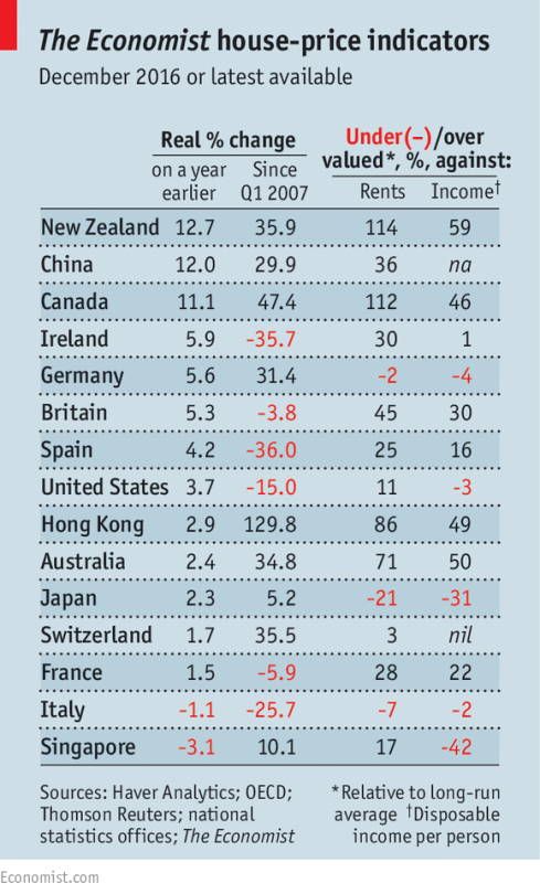
    The Economist recently published the following chart alongside this article talking about the impact of foreign buyers on global house prices.

    image

    They also have this set of interactive graphs that allows you to chart prices according to a number of different measures. The two metrics that The Economist focuses on (above) are house prices against rents and house prices against incomes. 

    The argument they make is that as (foreign) capital begins to think of property as merely a bolthole, it can start to detach itself from fundamentals such as rents and incomes. New Zealand, Canada, and Australia are specifically called out.

    This isn’t necessarily news. And one chart can only tell you so much. But I like staying on top of the various indices.

  • Global home prices at the end of 2015

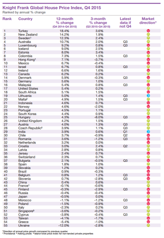
    Seeing how we’ve started looking at data from last year, I thought it would be interesting to look at global home prices as of Q4 2015. Here’s a chart from Knight Frank, which they refer to as their Global House Price Index:

    At the top of the list is Turkey, with an 18.4% increase from Q4 2014 to Q4 2015. (Supposedly this is because it has recently become easier for foreigners to buy property in the country.) Canada is 13th with a 6.2% increase (during this same time period) and the United States is 17th at 5.4%.

    This is obviously a high level analysis. There are lots of regional and local variations within each country. For instance in Canada right now, Calgary is a very different place than, say, Vancouver or Toronto.

    Nonetheless, it’s still valuable to see the relative performance of each country and see what their (Knight Frank’s) prediction is for 2016:

    “Our outlook for 2016 is muted. We expect the index’s overall rate of growth to be weaker in 2016 than 2015. The global economy is experiencing a potentially dangerous cocktail of low oil prices, a strong [US] dollar and a continued slowdown in China.”

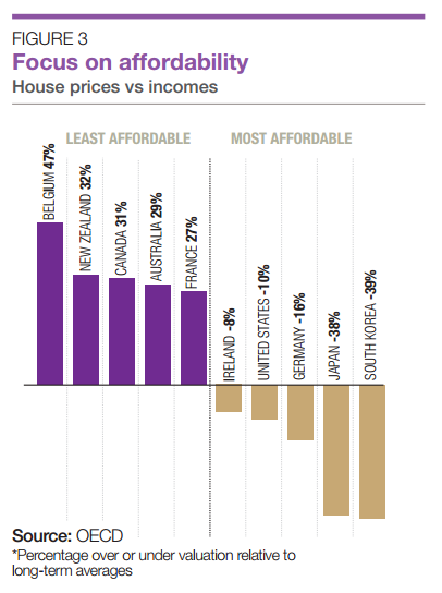
    It’s also interesting to see how the countries rank in terms of affordability:

    Once again, Canada ranks as being one of the least affordable countries in terms of home prices.

  • Guest Post: Three minutes that rule the world – Will demolishing the Gardiner East actually make traffic worse?

    Today on Architect This City, we have a guest post by Darren Davis, who is a transport planner in Auckland, New Zealand. He’s a regular commenter on this blog, and I know he’s been following the Gardiner East debate quite closely – as many urbanists around the world are. I appreciate him offering and taking the time to write this piece. Thank you.

    ——————————–

    The decision this month on whether to demolish the Gardiner East Expressway and replace it with a surface boulevard or to rebuild it with a similar elevated structure will be a watershed moment for Toronto, akin to the decision not to have freeways in the urban core of Vancouver in the late 1970s.

    There are numerous good reasons why removing the Gardiner East elevated structure is the right move for Toronto, covered previously by The Globe and Mail and in the Council for Canadian Urbanism’s open letter to Toronto City Council. If you aren’t aware of these, I strongly recommend reading them. 

    Also of note are two things:

    1. Just 3% of Downtown commuters drive on the Gardiner Expressway East, a tiny fraction of the 68% who arrive Downtown on public transit.
    2. The “remove” option does not reduce traffic capacity over the “hybrid” option but could reduce travel speeds in uncongested conditions (read on for why I don’t think that this will happen in real life).

    However, one element of this debate that has not got much airtime is the transportation modelling that claims an additional two to three minutes travel time with the “remove” option over the “hybrid” option which retains the elevated expressway in a slightly modified form. 

    Toronto Mayor John Tory has stated that "I didn’t get elected to make traffic worse. And let’s be clear, removing that piece of the Gardiner will almost certainly make traffic worse.” But is it in fact true that demolishing the Gardiner Expressway East will make traffic worse as the transportation modelling claims?

    The key thing to understand is that transportation modelling, which tries to predict future travel times, is the product of a bunch of assumptions which may not in fact be borne out in real life. 

    For example, the effect of induced traffic, where additional traffic capacity leads to additional traffic being attracted to the route, is reasonably well known but generally not factored into transportation modelling. Induced traffic happens because increased travel speeds attracts traffic that would have otherwise avoided the route at congested times; attracts people to drive where they previously used other modes and encourages trips that would not otherwise have taken place. The effect of induced traffic is to quickly nullify the benefits of adding traffic capacity.

    However, what is less well known is that the reverse happens where there is either a reduction in traffic capacity (not the case in Toronto as the “remove” option retains the same traffic capacity) or speed.

    This is because in this situation, four things happen:

    1. Some travel re-routes. The “remove” option with a widened Lakeshore Boulevard as part of the street grid simply gives more ability for traffic to re-route away from congestion over an elevated expressway structure where drivers are literally trapped until they reach their exit.
    2. Some travel re-times. Some people will retime trips to avoid congested travel times, such as starting and/or finishing work at less congested times.
    3. Some travel changes mode. Some people will be encouraged to change mode by the perceived worsening in traffic conditions.
    4. Some travel is avoided entirely. Some people will choose not to travel at all in the peak of the peak. For example, this could take the form of working from home or shopping on the internet instead of by car.

    Transportation models only take into account the first item but not the others. The modelling is also sensitive to traffic growth assumptions and assumed mode split and trip distribution. Often transportation models assume continued growth in car travel even though per capita kilometres travelled peaked about a decade ago.

    While this may all sound well and good theory, does this actually happen in practice?

    In Auckland city centre, we have extensive experience with the reallocation of road space away from general traffic. Many busy key city centre approach routes have had general vehicle lanes reduced to make way for bus lanes (which generally carry around 65-70% of the people moving capacity of the street). 

    This has involved up to a 50% reduction in private vehicle capacity (whereas in Toronto, the “remove” option retains the same traffic capacity but may slow throughput). Auckland has done two of these in the past twelve months – both involved converting a general traffic lane to a bus lane. 

    Don’t get me wrong: There is sometimes pain at implementation with about a three week period of congestion as car drivers adapt to the new reality – and most likely negative media coverage will accompany this. But after about a month, equilibrium will be restored and life will continue much as it did prior to the change. 

    Part of this is that there will be various “optimisations” during this introductory period where signal timings are adjusted and other tweaks made – the sort of tweaks that can only be fine-tuned in a real world situation. But a bigger part of this is that the four factors above – re–routing, re-timing, mode change and avoided travel – come into play.

    I cannot overemphasise enough that life will return to normal surprisingly soon if the Gardiner East Expressway is demolished and replaced by a widened Lakeshore Boulevard.

    My advice

    When people talk about two to three minutes of extra travel time, take the foregoing into account and take those claims with the very big grains of salt that they deserve. If Toronto makes the right choice and chooses the “remove” option, my bet is that the biggest surprise of all will be how little difference it makes to peak travel times for the 3% of Downtown commuters who used to use the Gardiner Expressway East.

    Disclaimer

    The author of the above post is an employee of Auckland Transport, however, the views, or opinions expressed in this post are personal to the author and do not necessarily represent the views of Auckland Transport, its management or employees. Auckland Transport is not responsible for, and disclaims any and all liability for the content of the article.

  • 5 city builders who read Architect This City

    image

    A few weeks ago I wrote about showcasing the Architect This City community. The idea was that there are lots of interesting and talented people who subscribe to this blog, but that there’s no scalable way for me to connect with everyone.

    So I wanted to provide an opportunity for you to share a bit about yourself on this blog. I could selfishly learn more about the kinds of people who read ATC; you and/or your company could benefit from a bit of exposure; and you all could get the opportunity to connect with one another.

    I didn’t get quite as many responses as I thought I would — which is partially why it has taken me so long to write this post — but I did get a lot of positive feedback on the idea. So I’m excited to share 5 of the people and companies that did respond.

    Darren Davis @ Auckland Transport (Auckland, New Zealand)

    Proudly car-free Principal Public Transport Planner, and arch transit nerd, at Auckland Transport. Auckland Transport is in the midst of the biggest redesign of the city’s public transport system since the introduction of electric trams in 1902. We are taking a once-in-a-generation opportunity to reimagine public transport by going back to first principles, in an exercise inspired by Human Transit and strongly influenced by its author, Jarrett Walker. 

    Travis Goodhand @ Entuitive (Calgary, Canada)

    We are a consulting engineering practise — structural, building envelope, restoration, and special projects & renovations — bringing together engineering and intuition to enhance building performance. Entuitive is creative, collaborative, and advanced.

    Taya Cook, Development Director @ Urban Capital (Toronto, Canada)

    We develop forward thinking condominiums with a focus on urban location, fantastic design and superior customer experience. I work there. Really B, do you need more reasons for awesomeness?

    Sara Parratt-halbert @ South Yorkshire Forest Partnership (Sheffield, UK)

    Currently managing a Europe-wide €4m ERDF funded project, ‘Stimulating Enterprising Environments for Development and Sustainability’ (SEEDS).  SEEDS is working with 8 partners across 6 countries towards establishing acceptance of the temporary use of abandoned places and spaces as an integral part of longer term planning.

    Cynthia Mykytyshyn @ Urbanspace Gallery (Toronto, Canada)

    Urbanspace Gallery is a unique venue, dedicated to diverse exhibitions and events that explore how cities work and how we might improve them. Our purpose is to present issues related to community, public space, housing, transportation, planning, governance, and sustainability (among others) in order to further the discussion about our own city and others around the world, while fostering a space of learning and reflection.

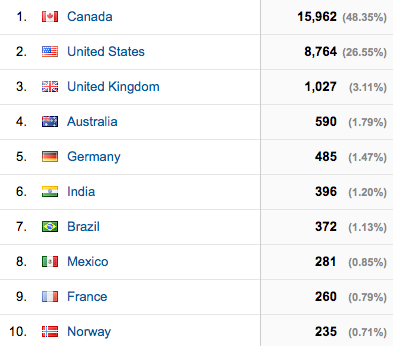
    Most of the people who responded were from Toronto and Canada. And that’s not surprising given how local a lot of my content is. Half of the ATC reader base is currently from Canada.

    image

    But I did also get emails from many other places all around the world. It always amazes me to see where people are reading from. My only wish is that I could learn more from them (you). So drop me a line. I hope to do another community profile sometime soon.

    Many thanks to everyone who responded!

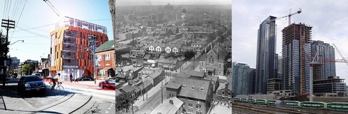
    Image: How Does Your Neighbourhood Grow? (Urbanspace Gallery)