Daily insights for city builders, delivered every morning at 6 AM ET. I’m Brandon Donnelly — a Toronto-based real estate developer and founder of Globizen. I’ve been writing here since 2013.

Tag: neighbourhoods

  • Will fourplexes be actually feasible in Toronto?

    Last week I wrote about Toronto’s plan to make fourplexes as-of-right across the city, but also why this form of missing middle housing shouldn’t have a maximum floor space index.

    Today, let’s look at the numbers in a bit more detail.

    If you look at a zoning map of Toronto, you’ll see that many neighborhoods across the city have a maximum floor space index (FSI) of 0.6. What this means is that if you have a piece of land like this:

    • Lot width: 20′
    • Lot depth: 115′
    • Site area: 2,300 sf

    Your total allowable gross floor area would be 1,380 square feet (0.6 x 2,300 sf).

    If you build a laneway suite in this city, that won’t count towards your total allowable GFA (otherwise they’d be very challenging/impossible to build). But if you want to build something like a triplex or a fourplex, it counts.

    The one important caveat is that if you’re building a residential building — that isn’t an apartment building with 5 or more homes — you can deduct the floor area of the basement:

    This, of course, helps the situation. But it doesn’t solve all of our problems.

    If you assume that the basement can be one home, that still only leaves 1,380 square feet for the other three, technically permissible, homes. This equals: 3 homes x 460 square feet.

    Another option would be 2 homes x 690 square feet. But still, we’re not exactly making it easy to deliver more “family-sized homes” in the city.

    And herein lies one of the problems (plural, because there are others). We can say that fourplexes are allowed across the city, but it may not actually be technically feasible or practical to build them.

    Note: I am not a planner. If you are, leave a comment below.

  • Thickets of haphazardly planned condo towers

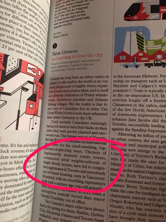
    I couldn’t sleep last night, so I got up and pulled out an old issue of Monocle magazine from my nightstand. I then stumbled upon the following article by Taras Grescoe.

    What really stood out for me was this line:

    “Thickets of haphazardly planned condo towers, compacted amid neighbourhoods of single-family houses, have led to congestion nightmares in Toronto and notoriously out-of-hand housing costs in Vancouver.”

    It bothered me for a few reasons:

    – The frame of reference is the single-family house. It perpetuates the cultural bias that what matters most in cities, like Toronto and Vancouver, is low-rise housing.

    – I don’t get the “haphazardly planned” comment. New tower development has been heavily concentrated in the downtown core, growth centers, along the Yonge subway corridor, and so on. Their built form is also significantly influenced by their relationship to these low-rise “Neighbourhoods.”

    – I believe that building up, as opposed to out, is the way to address congestion nightmares. Though I will concede that our ability to plan and execute on transit in this city is positively deplorable. 

    – How did thickets of condos create an affordability problem in Vancouver? Many factors at play in this city, including a powerful geographic supply constraint.

    Those are just a few of my thoughts from early this morning. What are yours?

  • Enhancement Zones: The mid-rise performance standard that didn’t make the cut

    I’ve written a lot about mid-rise development on this blog and elsewhere. 

    I recently wrote this post responding to a tweet by the Chief Planner of Toronto. And towards the end of last year, I wrote a longer piece for developer Urban Capital’s annual magazine. If you missed it, you should definitely download a copy. Not so much for my article, but because, overall, the UC magazines are excellent. (Credit to David Wex.)

    Today, I’d like to focus on one specific “performance standard” from Toronto’s mid-rise guidelines that I’ve been thinking about lately. But more specifically, I’d like to focus on a performance standard that was initially contemplated but never actually got adopted. 

    (I apologize in advance if this post gets a bit too geeky for some of you. It refers to a specific land use policy in Toronto, but it has much broader relevance.)

    If you take a look at the final Avenue & Mid-Rise Buildings Study and turn to page 56, you’ll see that Performance Standard #5B (Rear Transition to Neighbourhoods: Shallow Properties) was stricken from the report. It was never adopted as a standard.

    So what is this all about?

    This performance standard had to do with something called “Enhancement Zones”, which was proposed as a way to deal with shallow parcels of land on Toronto’s main avenues. You see, because of the other performance standards – namely the angular plane (see images below) – the depth of an avenue site is hugely important for determining what can ultimately be built on it.

    From the city’s perspective, this is a double edged sword. In the case of exceptionally deep lots, you can actually meet all of the performance standards while at the same time exceeding the recommended densities. But in the case of shallow lots, the performance standards sometimes/often make it so that you can’t even achieve the recommended densities. In fact, a lot of sites simply become un-developable.

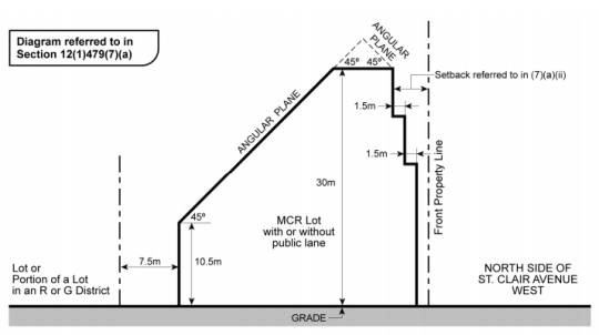
    To give you a visual for what I’m talking about, here’s a section drawing from a zoning by-law that was adopted by City Council for St. Clair Avenue West in midtown:
    image

    Here you can quickly see that if you were dealing with a shallow lot of, say, 25m in depth, you wouldn’t have much left over after taking into account the rear property line setback (7.5m above), the front property line setback, and the 45 degree angular plane. Now you’re beginning to see why I said that it is easier said than done to play creatively within the guidelines envelope (thick black line above). When you look at the feasibility of these projects, you quickly end up getting pushed right up against the glass.

    But this is where Enhancement Zones comes in. 

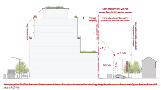
    The idea here is that an adjacent low-rise residential property (or pair of properties in the case of attached houses) could be included in mid-rise development proposals to create a deeper site that then meets the requisite separation distances between the mid-rise scale and the low-rise scale. To be clear, nothing would be built in the Enhancement Zones. They would just help to relieve some of the setback pressures from the original shallow lot and maybe even create a rear laneway system where one did not exist before.

    Below is a drawing from the Mid-Rise Buildings Study showing that new condition. The same 7.5m setback applies at the rear, but now it sits within an Enhancement Zone – formerly an adjacent and separate property. All the text is crossed out because, again, this standard was not adopted.
    image

    From a mid-rise development and feasibility standpoint, this makes a lot of sense. Sites that may have been un-developable before, now become developable. This makes it easier for us to achieve the European-scaled mid-rise vision that Toronto has for its avenues.

    But for reasons that I am sure you can guess, there are concerns with this performance standard. Probably the most obvious is that, to a certain extent, it destabilizes “neighbourhoods.” And they are intended to be completely stable entities that see little to no intensification. As soon as you allow this to happen, properties sitting in Enhancement Zones would become the prey of developers.

    However, there are counter arguments you could make. The owners of these properties would likely receive offers above market value. So maybe they end up better off. At the same time, you could also argue that the more development we unlock outside of “neighbourhoods”, the more stable they can actually remain.

    In any event, I’ve been thinking about this lately and I thought it would be interesting to debate the pros and cons of these magical-sounding Enhancement Zones. For those of you inclined to engage in geeky planning discussions, I’d love to hear from you in the comments.

  • What’s in a neighborhood?

    image

    When I was working on my startup Dirt last year, one of the things we spent a bit of time figuring out was how to classify buildings according to neighborhood. Now, at first blush, this may seem like a fairly easy thing to do. You simply locate the building, figure out which neighborhood it’s in, and then tag it accordingly. But neighborhood boundaries and definitions aren’t as clear cut as you might think.

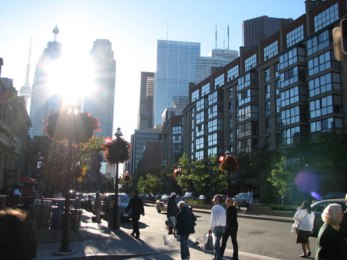
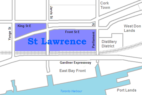
    For example, a lot of you probably know that I live in the St. Lawrence Market neighborhood of Toronto. And indeed, if you look at this Wikipedia definition, I live in that area. But if you look at what they call it, it’s just: “St. Lawrence.” They also specify that it used to be called “St. Lawrence Ward”, but that today most people actually call it “the St. Lawrence Market.” So here you have an example of an evolving and changing name.

    image

    But then there’s the question of boundaries. According to Wikipedia’s definition, the north boundary is Front Street. This means that the North Market Building would be technically outside of the area and so would the Market Square condos. But I suspect that almost everyone would consider these two buildings to be part of the neighborhood. So where exactly is the north boundary? Is it King Street? Or maybe by Front Street they mean that all buildings on the north side of the street are included.

    If you look at the city’s official neighborhood list (which is built from Statistics Canada Census Tracts) you’ll find a completely different boundary and name. According to this list, I live in the “Waterfront Communities–The Island” neighborhood. Obviously nobody, other than maybe somebody who deals with census data, would have any idea what this area is. But it’s how the city tracks its demographic data.

    What this begins to show you is that neighborhood definitions and boundaries aren’t as black and white as they might initially seem. And it’s partially because cities themselves are always in flux. New neighborhoods emerge and old ones reinvent themselves. And as that happens, people start introducing new names and new terminologies.

    image

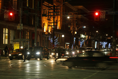
    When I was about 19 years old, people in Toronto used to say they were going out “on Richmond and Adelaide.” Since then, gentrification has pushed many of the bars and clubs out of that area. So people instead go out “on King West” or “on Ossington.” And as people begin to use those terms and identify with an area, new brands are created. Ask anybody who lives downtown and I bet they’ll tell you that King West has its own unique personality and even a type of person who typically lives there. This is an on the ground type of awareness though, which doesn’t get captured in census tracts.

    The other reason neighborhood boundaries can be so fuzzy is because we – the real estate community – are constantly trying to manipulate them for our own benefit. I’m indifferent to the fact that this happens, but it is a reality. Think about how much the neighborhood of Yorkville has been stretched from its original roots north of Bloor Street. If a neighborhood has a good brand, agents and developers will naturally try and leverage it. Homeowners do it all the time too. Would you prefer to say that you live in Seaton Village or the Annex?

    Ultimately, we (my Dirt cofounder and I) decided that neighborhood definitions and boundaries needed to be fluid. They needed to dynamically adjust with the market and come from as many people as possible on the ground. Because at the end of the day if the official documents say one thing, but the majority of city residents believe another, then that official boundary and definition are probably out of date. The crowd wins here.

    We liked this approach because it was organic – just like cities.

    Images: Flickr, Wikipedia, Flickr

  • I’d raise kids in an apartment

    One of the North American truisms that I often like to challenge is the belief that kids should be raised in a house.

    I’m interested in this topic, not because I’m planning for a kid, but because Toronto has gone through such a dramatic transformation over the past 15+ years to become a city where more and more people are living in multi-family dwellings (condos, apartments, and so on).

    However, there’s still the belief amongst many circles that condo living is merely a stepping stone on the way to a house. Since Millenials have effectively added a new life phase between University and marriage, condos have become the home of choice for many twenty and thirty somethings. But how long will they stick around? I see a lot of people in my network getting married and subsequently moving from a condo to a house.

    Why is this?

    Is it because of schools? Is it a cultural belief that families require a house and a backyard? As someone who grew up in the suburbs, I can tell you that I never played in the backyard. I played on the street with other kids. I used a shared public space rather than a private one.

    On a practical level, I think the condo-to-house tradition has a lot to do with the fact that condos are just more expensive on a per square foot basis than wood-framed houses. For the same price that you might pay for a small 2 bedroom condo in Toronto, you could still conceivably buy a 3 bedroom house in some inner city neighbourhood.

    But the supply of single family homes in the city is limited. We’re not adding anymore. So as the price of these homes continues to increase – at what is now a faster rate than high rise housing – we may eventually reach a point where there’s no longer a cost savings associated with low-rise housing. In fact, they’d just be a luxury for the well-heeled.

    In this scenario, I think we’d naturally see an increase in larger condo units – something the city has been trying to artificially encourage. And out of necessity, we’d see more and more families in condos. However, it’ll take a change in mindset. Are you ready for it? I’d like to think that I am.

  • Get to know Riverside | Dirt.

    Whatever you do, don’t call it Leslieville. It’s RiversideSpanning 10 blocks along Queen Street East from the Don Valley Parkway to Degrassi Street, this part of town often gets rolled up into the hyped Leslieville neighbourhood. But they’re not one in the same. Formerly known as Queen Broadview Village, Riverside is a small neighbourhood within the larger South Riverdale precinct. But what it may lack in size, it certainly makes up for in terms of culture and history.

    Get to know Riverside | Dirt.