Daily insights for city builders, delivered every morning at 6 AM ET. I’m Brandon Donnelly — a Toronto-based real estate developer and founder of Globizen. I’ve been writing here since 2013.

Tag: multi modal

  • We need far better urban data

    The divisive debate over bikes lanes in Toronto continues to remind me that we need far better urban data. People and politicians keep touting “evidence-based decisions,” but what exactly is that evidence? The high-level figure being thrown around by the anti-cycling side is that only something like 1% of residents use bike lanes. So obviously it only makes sense to focus on the 99% and not give up any space to this small minority group.

    But this is highly aggregated data. It also doesn’t speak to any of the externalities associated with introducing new bike infrastructure. Looking at 2021 Census data, the number of cyclists was actually around 5% for the old City of Toronto and in some areas it was between 15-20%. However, it’s absolutely critical to note that this is only the people who selected cycling as their “primary mode of commuting” when submitting their responses to the last census.

    Meaning, it excludes people who maybe only cycle 1-2 days a week, or who ride for leisure and/or for exercise, or who ride to their French class in the evenings (like me). I would also assume that these numbers have generally grown since 2021 given the overall investments that have been made in biking infrastructure. So overall, this is weak data. It’s a few years old. And it excludes many types of users. We need to get more granular.

    Like, it’s great to see local business owners speaking out about the benefits that they have seen as a result of the Bloor bike lanes, but in the end, this is also anecdotal. We need real-time data, precise modal splits, the throughput of every major street, and much more. Then maybe we’ll be able to better optimize around the fact that we are a city divided by built form and by politics. That’s the thing about evidence-based decisions, they tend to get stronger with accurate evidence.

  • Just give me the fastest option

    I had a dinner in the suburbs this evening. And so in the afternoon today, I opened up Google Maps to figure out how I was going to get there.

    I didn’t have my car with me — because I hate driving into the office — so in my mind, I was either going to take transit or take an Uber.

    These are the time estimates that Google gave me:

    It was going to take me over 4 hours to walk there. Over an hour to drive there. And 47 minutes to take the train there. Interestingly enough, cycling was also going to be faster than driving.

    As soon as I saw this, I shut down the app and decided I would take the train. All I was interested in was the absolute fastest option. And for me at that moment, it was the train.

    I recognize that this isn’t always the case. Sometimes driving is much faster than taking transit. It depends on a number of factors.

    But as a general rule, when it comes to big and dense cities, you really can’t beat trains and bikes for moving the greatest number of people, as quickly as possible.

  • Ridesharing could help solve the last mile problem

    X by Keith Mokris on 500px.com

    https://500px.com/embed.js

    A few months ago I wrote a post about Uber’s new “Smart Routes” feature and ended by saying that it’s not just taxis who need to be thinking about platforms like Uber, it’s also public transit authorities.

    I said that because I think that multi-modal is already the new reality in terms of how we get around cities and because the line between different modalities is becoming greyer all the time.

    That’s why I was interested when I stumbled upon this NextCity article talking about how Lyft is starting – it’s still early days – to collaborate with transit authorities in order to make it easier for people to switch between public transit and its peer-to-peer ridesharing marketplace.

    Why might this matter? Here’s an excerpt from the article:

    “According to the company’s data, 25 percent of Lyft riders say they use the service to connect to public transit. In Boston, 33 percent of those rides start or end near a T station. And transit hubs like Chicago’s Union Station, D.C.‘s Union Station and Boston’s South Station are among the most popular destinations for its users, Lyft finds. So riders already see on-demand rides as a solution to the first mile/last mile problem. Lyft thinks it can do more.”

    These last 2 sentences are interesting. Public transit can often suffer from what is known as the first mile/last mile problem. This is a problem where riders find it difficult to get to the nearest transit route from their departing point or to their ultimate destination once they exit transit.

    Bikesharing can be used to solve this. But, clearly, so can ridesharing.

    The other important aspect of this emerging collaboration is that ridesharing apps can offer a lot of incredibly valuable data to transit authorities. If 25% of users are indeed using it to connect to public transit, then all of a sudden cities are getting a more complete picture of point A to B travel. (Among many other things.)

    But the question in my mind is now, who is going to and who should act as the overall steward in this multi-modal urban mobility network? 

    There are lots of different players involved. Some are public and some are private. But they all play a role in how we are going to continue moving around our cities.

  • Riding the new streetcar

    image

    This afternoon I rode Toronto’s new streetcar for the first time on my way home from Chinatown. I had been meaning to do it for weeks now, but this was my first opportunity.

    The experience was infinitely better than what you get today on our current streetcars. I felt like I was in a new city. The proof-of-payment system makes onboarding much faster and the 4 loading doors means you just get on the train where there’s the most room – instead of getting on at the front and fighting your way to the back.

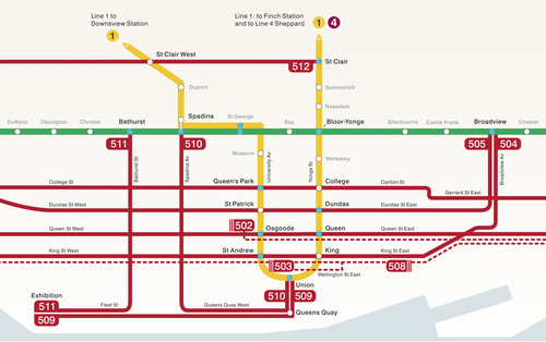
    The other thing I liked is that they now have a map of our streetcar network within the train (see above image). Toronto never used to do this. For whatever reason, we didn’t like mixing subway lines with streetcar lines on the same map. 

    But why be so pedantic?

    For one thing, our subway map looks pathetic without these additional streetcar lines on it. So for the sake of Torontonian morale, please fill it up with what you can.

    But the other reason why I think it’s important to include them is that we shouldn’t be thinking about our cities just in terms of specific technologies (subway, streetcar, and so on). Our cities are now multi-modal. Which means we navigate them using many different means, from subways and streetcars to bikes and Uber cars. What people care about is getting from A to B in the most efficient and enjoyable way possible.

    This may seem like a subtle distinction, but it’s an important one. And maybe, just maybe, these new maps will serve as an important reminder to us that there’s a lot of fixed rail in this city and that it could be far better optimized if we just tried a little harder.

  • Multi-modal cities are the new reality

    CityLab published an article last week on multi-modal cities that caught my attention (because it used a picture of Toronto with about 3 or 4 streetcars stacked up along Queen Street). The premise of the article is that all of this car vs. transit debate is actually missing the bigger picture: our cities are multi-modal and we need to be planning for that.

    That’s not to say that the shift away from cars isn’t a good thing. It is. But it’s not as simple as saying that, instead of driving, people should now only take transit. In today’s cities people walk, bike, take streetcars, take buses, take subways, take taxis, take private shuttles, use Uber, and, yes, they still drive.

    From my own experience, this is absolutely how I get around Toronto today. I walk to the gym. I ride my bike whenever I’m going somewhere downtown. I take the subway to my office in midtown because it’s far and I would be too sweaty if I biked there. I use Uber and Hailo when I’m going out at night. And I drive when I need to go to the suburbs or leave the city.

    But the key takeaway here is that we now have a much tougher challenge on our hands. When we were only optimizing for cars – however detrimental to our cities that was – we only had one mode to plan for. Now we have several. Some of which are public and some of which are private.

    However we also have access to technologies that we didn’t have before. We are networked in ways that weren’t possible before and we’re at the dawn of many profound mobility changes, such as driverless cars. (Have you read about Tesla’s new Autopilot feature yet?)

    So as I’ve said before, I really believe that we need to look at this, not as a war on the car, but as a war on inefficiency. The problem we are trying to solve relates to mobility: What’s the best way to move lots of people around dense urban regions? Stop focusing so much on the technologies and focus more on the people.

    Image: Flickr