Daily insights for city builders, delivered every morning at 6 AM ET. I’m Brandon Donnelly — a Toronto-based real estate developer and founder of Globizen. I’ve been writing here since 2013.

Tag: mta

  • Manhattan is still looking at a congestion charge for south of 60th Street

    We talk a lot about congestion charges and road pricing on this blog. Here’s a list of some of those posts. I found 46 that were tagged with “road pricing.”

    I continue to believe that it’s the only way that big cities can effectively solve the problem of traffic congestion. It’s not being caused by the bicycle lanes that were just added to your street. It’s not the new COVID street patios. And it’s not the new apartment that was just built with too many parking spots.

    The problem is mispricing.

    If you want free roads, then you don’t get free-flowing traffic. That’s how this equation works, which is why I have always thought it a good idea to dynamically price roads based on demand, and then to direct those funds toward more efficient forms of mobility — such as transit.

    Despite all this, it’s not a very popular approach in this part of the world. Toronto looked at road pricing back in 2016, but we got nervous and backed away from it. New York City has also been looking at a congestion charge for Manhattan south of 60th Street for at least 4-5 years. But this one appears to still be on the table.

    According to this recent CityLab article, New York’s congestion prices could look something like this (note that this chart includes other pre-existing tolls):

    But with some exceptions (I think this is an interesting approach):

    Primary residents of the Manhattan central business district, which is south of 60th Street, and New York State residents with adjusted gross income of less than $60,000 would be eligible for a state tax credit equal to the amount of the new tolls, paid during the taxable year.

    In total, this current pricing scheme is expected to generate an additional $1 billion in annual revenue for the city’s transportation authority. The MTA also plans to bond against this revenue and raise an additional $15 billion for new transit projects.

    This sounds like a reasonable approach to me.

  • New York City rolls out contactless fare payment at every single subway station

    I’m late to the party here, but I was reading this morning about how New York City recently completed the rollout of its One Metro New York (OMNY) fare payment system. What this does is allow you to use contactless payment systems, like Apple Pay, to get on the subway. ONMY is now available across the five boroughs on every bus and at all 472 subway stations (feel free to impress your friends at virtual parties with this stat).

    Metrolinx here in Toronto is similarly piloting contactless payments on the Union Pearson Express. You now have the option of tapping a credit card, a phone, or a watch. Maybe this doesn’t seem like such a big deal, but I still remember when the PRESTO payment card was first rolled out — it felt late to me. Apple added near-field communication (NFC) to iPhone in 2014, and at that point I think it was fairly obvious that standalone payment cards wouldn’t be around much longer.

    That time has arrived for New York City and will be hopefully arriving shortly for Toronto. And I think it will be particularly useful for tourists who may not have a Metrocard (NYC) or PRESTO card (Toronto) and just want to jump on a train. I’ve only taken the subway a handful of times during this pandemic, but I’ll be back at it once the world fully resumes. And I definitely can’t wait to take the UP Express to the airport again (and to the Junction).

  • The Map: Geometry vs. geography

    A friend of mine sent me this video today in a brief email that basically said, “you’re gonna love it.” Naturally he was right. It’s great. The 10-minute video is about how creative agency Work & Co rethought and redesigned New York City’s subway map for today’s digital age. Rather than a static map, which is historically how all cities have communicated their transit networks, they created a digital map that changes both as you interact with and as the network itself changes (closures, time of day, etc.). This means that they no longer had to make certain design compromises. They no longer had to choose between geometry (clarity of representation) and geography (accuracy of representation). The system does both.

  • Fixing the MTA

    Fred Wilson wrote a great post on his blog today about New York City’s “transit mess.” 

    In it he talks about congestion pricing (which, as you all know, I support); the mess that is the Metropolitan Transportation Authority (MTA); and this 37-page report on how to improve the MTA.

    Here is an excerpt from his post that I liked, but that won’t be popular with everyone:

    That is an idea [congestion pricing] that has been proposed a number of times over the years, most notably by Mayor Bloomberg during his tenure. It is a good idea and long overdue. A dense urban environment should have excellent mass transit and incentives to use it and should have disincentives to drive cars. Taxing cars in Manhattan and using the revenues to maintain and improve our subways seems like an obvious thing to do.

    I would encourage you to give his post a read. The New York Times also reported on this topic (and the above recommendations) this week. They called it, 7 ways to fix the MTA (which needs a $60 billion overhaul).

    Photo by Joren on Unsplash 

  • The worst on-time performance of any major transit system in the world

    I was recently with some New Yorkers and we got on to the topic of their subway system. I made a comment about how extensive their network is and how their express trains work so well for traveling further distances. 

    They responded by basically saying: “Yeah, it’s great, when it works.” They then went on to tell me that most of the time they just use Uber to get around the city because the subway has become so unreliable.

    Admittedly, I don’t use the NYC subway system enough to comment on its declining performance. But this recent New York Times article describes it as an utterly failing system.

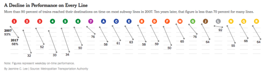
    Here is a diagram from the article that shows performance on every line (2007 to 2017), measured as a percentage of trains that reach their destinations on time (i.e. less than 5 minutes late):

    image

    In 2007, more than 90% of trains reached their destinations on time. Today, the weekday average is around 65% and some of the lines are in the 30s. This is the worst it has been since the 1970s when NYC was almost bankrupt.

    Apparently this also awards NYC’s subway the title of the worst on-time performance out of the world’s top 20 biggest systems.

    I suppose one of the lessons here is that subway lines on a map will always be far sexier than the nuts and bolts of maintenance, performance, and ridership. But we can’t forget the nuts and bolts. Maybe those are the most important parts.

  • Bringing public transit into the 21st century

    New York Subway by Lok Yiu Cheung on 500px.com

    https://500px.com/embed.js

    I think we’ve hit peak millennial.

    Last Friday the Governor of New York, Andrew Cuomo, and the Metropolitan Transit Authority, announced that 30 subway stations will be redesigned and that “millennial-friendly amenities” would be added throughout the system. 

    As you might guess, this includes adding phone chargers in train cars and buses and wifi throughout all the stations (by the end 2016). They will also be replacing the MetroCard with an all digital fare system that will include mobile payments.

    But the reality is that this isn’t about being millennial-friendly. This is about joining the 21st century.

    Here in Toronto, we finally have our PRESTO card working on all streetcars and in almost 40% of the city’s subway stations. This is a huge improvement over our laughable and antiquated token system, but it’s not enough. I really hope the next rollout is a mobile app that will allow everyone to pay with just their phone.

    We also have wifi in about 30% of our subway stations, but again this is not enough. By the time you get authenticated (do you need to have Twitter now?), your train is usually arriving and then you enter a tunnel where no wifi exists. We need to be looking at the entire tunnel network. (Related topic: LinkNYC) 

    I say all this because I am a big supporter of public transit. Despite all the positive things I write about Uber, ridesharing, and driverless cars, I do not believe that they will eradicate the need for a strong transit backbone. This is fundamental to our city building efforts. 

    So let’s do our best to delight people when they take transit.

  • Express trains

    A lot of people love New York. They love it for the culture, the nightlife, the shopping, the opportunities, as well as for many other reasons. And these are all great reasons. But being the city geek that I am, there’s another reason I think New York is great: express trains.

    Broadly speaking express trains are simply trains that run faster than other trains on a network. In the case of New York, there are express trains and local trains. The latter stop at every station and the former typically just stop at major transfer points.

    To make this all work, the New York system uses a 4 track system. There are 2 tracks headed in each direction with the local train on the outside track and the express train on the inner track. On stations where the express trains stop, the 2 tracks split from each other and the platform sits in the middle so that you can switch across the platform from express to local (and vice versa).

    The benefit of express trains is obvious. It makes it significantly faster to travel long distances. And it makes, in a lot of cases, taking the subway the fastest alternative. That’s how transit should be.

  • Is Hong Kong’s transit model exportable?

    Hong Kong’s MTR (Mass Transit Railway Company) is one of the most profitable transit systems in the world. Rider fares amount to roughly 186% of its operating costs.

    In comparison, Toronto recovers about 70% of its operating costs from fares and New York recovers 57%. This means that in the latter two cases, government subsidies are required to keep the systems in operation.

    On top of this, Hong Kong relies on a unique “rail plus property” model, meaning that they also use the profits from real estate development activities to fund transit expansion. Here’s more on how it works:

    “In a value capture scheme, MTR is granted low-cost land around its future stations [from the government]. It then develops the land and uses the profits to pay for system expansion. Through this system, MTR has managed to build subways and elevated rail lines throughout the islands that make up Hong Kong, largely paying its own way.”

    Overall, this seems to make a lot of sense. Which begs the question, could this model – specifically “rail plus property” – be exported to other cities?

    NextCity asked this question with respect to New York, but came up with 3 problems: first, New York has an operating shortfall, unlike Hong Kong; second, New York doesn’t have the same amount of government owned land; and third, construction costs are way higher in NYC.

    The first thing that comes to my mind is, why are Toronto and New York so bad at farebox recovery? Our infrastructure is not self sustaining; we’re reliant on government handouts.

    Looking at fare pricing, there’s a big difference between the cities. Hong Kong charges based on distance traveled, whereas Toronto and New York charge a flat rate. Intuitively, dynamic pricing makes sense, since you’re then able to capture shorter rides that would otherwise be replaced by walking (or other alternatives) and you capture more value during longer rides.

    The other big difference is the hyper density of Hong Kong, since we know there’s a correlation between urban density and transit ridership. I would assume that the demand for most of their rail lines is fairly high. And it’s for this exact reason that I’m opposed to the new Scarborough subway line here in Toronto. Building subways in areas of the city without the densities to support it will only exacerbate our farebox recovery problem.

    As for the other two points regarding government land and high construction costs, I have to believe that there’s a way to create a “rail plus property” model that circumvents these concerns.

    For one, why does it have to be government land? Could we not reward developers with additional density if they build a subway station in the basement of their new building or contribute to a transit fund? The city already allows additional density near subway stations. Why not do the same for locations where we simply want a station?

    Transit is too important not to get right. I hope Toronto will soon understand that.