
Daily insights for city builders, delivered every morning at 6 AM ET. I’m Brandon Donnelly — a Toronto-based real estate developer and founder of Globizen. I’ve been writing here since 2013.

Tag: modal split

  • We need far better urban data

    The divisive debate over bikes lanes in Toronto continues to remind me that we need far better urban data. People and politicians keep touting “evidence-based decisions,” but what exactly is that evidence? The high-level figure being thrown around by the anti-cycling side is that only something like 1% of residents use bike lanes. So obviously it only makes sense to focus on the 99% and not give up any space to this small minority group.

    But this is highly aggregated data. It also doesn’t speak to any of the externalities associated with introducing new bike infrastructure. Looking at 2021 Census data, the number of cyclists was actually around 5% for the old City of Toronto and in some areas it was between 15-20%. However, it’s absolutely critical to note that this is only the people who selected cycling as their “primary mode of commuting” when submitting their responses to the last census.

    Meaning, it excludes people who maybe only cycle 1-2 days a week, or who ride for leisure and/or for exercise, or who ride to their French class in the evenings (like me). I would also assume that these numbers have generally grown since 2021 given the overall investments that have been made in biking infrastructure. So overall, this is weak data. It’s a few years old. And it excludes many types of users. We need to get more granular.

    Like, it’s great to see local business owners speaking out about the benefits that they have seen as a result of the Bloor bike lanes, but in the end, this is also anecdotal. We need real-time data, precise modal splits, the throughput of every major street, and much more. Then maybe we’ll be able to better optimize around the fact that we are a city divided by built form and by politics. That’s the thing about evidence-based decisions, they tend to get stronger with accurate evidence.

  • Toronto’s congestion crisis needs solutions, not politics

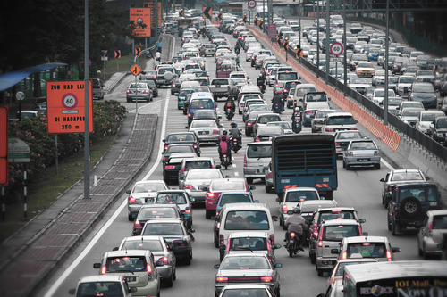
    People in Toronto are deeply and rightly frustrated about our traffic. We have truly world-class congestion. But here’s the thing, the way we’re going about solving this problem is all wrong.

    Transportation staff seem to believe that congestion charges would not reduce or deter traffic from coming into Toronto. Never mind all the global precedents, never mind that we have the tolled 407 highway to look to, and never mind that economics tells us that when the price of something increases, the quantity demanded decreases.

    Instead, we seem to think that we can solve this problem with fewer bike lanes, improved traffic management, and better policing, including higher fines for disobedience. (Interestingly enough, higher fines are supposed to deter people, but congestion charges won’t do the same. I’m confused.)

    None of this will fix the mess we’re in.

    This is a case of politics over data and experience. Identify something that people are pissed off about, and then create the illusion that you’re doing something to fix it. Good politics. But the reality is that this problem is much trickier to solve. It will require vision and meaningful change. That’s a much tougher sell.

    Think of this way. Can you identity a large car-oriented global city with millions of people that doesn’t have a traffic congestion problem? Even the Katy Freeway in Houston, which counts as many as 26 total lanes, has a congestion problem. And the last time I checked, it didn’t have any bike lanes.

    https://twitter.com/joshuahind/status/1837347617304424620

    Now let’s look at the largest city region in the world — Tokyo. The city proper has about 14 million people and the broader region has about 41 million. This is the entire population of Canada in one city region, and yet it’s generally viewed as being one of the most well-run and efficient cities in the world. How do they do it?

    Here are the modal splits within Tokyo’s 23 wards (2018 data):

    • 36% public transport (rail and bus)
    • 27% passenger cars
    • 23% walking
    • 14% bicycles and motorcycles

    Now compare this to the splits in Toronto’s census metropolitan area (2021 census data):

    • 76% passenger cars
    • 16% public transport
    • 5% walking
    • 1% bicycles
    • 2% other

    Of course, if we were to look at the modal splits within the core of the city they would look quite different and much closer to Tokyo’s numbers. This is why it can be so hard to achieve consensus on many city building issues — we are quite literally a divided and different kind of city.

    In the end, this is the root cause of our traffic problem. The vast majority of people in this city region drive. And they are not to be blamed. It’s because we’ve designed this to be the only practical option.

    But if we’re serious about solving congestion, it’s going to require some bold changes. It’s going to require reducing this 76% figure. We can fool ourselves into thinking that better construction coordination, fewer bike lanes, and higher fines will somehow solve this enormous and deep-rooted problem, but the inconvenient truth is that they won’t.

    What we need are real solutions. Is anyone going to take the lead?

  • A national walk to work day alternative

    I just learned that the US has a “National Walk to Work Day.” And it happens to be today, Friday, April 7, 2023. It was started in 2004 by the federal government and the American Podiatric Medical Association — because, you know, walking is good for your feet — and the idea is that since so few Americans actually walk to work, we should encourage them to do it at least one day of the year. Back in 2019, the figure was that less than 3% of Americans do it on average.

    While I’m sure that there are some good intentions here, I’m guessing that the impact of this national day is probably somewhere between zero and “I guess I’ll park in a farther spot at the office park today.” The reality is that a day like this exists because we have spent the last 75 years, or even longer, making it exceedingly difficult to navigate our cities without a car. So it is equal to, “let me speak out of the other side of my mouth for a day.”

    But we also know that a real and meaningful solution is pretty simple to achieve (though clearly not easy). Build smaller streets and build more densely, especially next to transit. (Would you add anything to this?) So I think it’s time for a new kind of national day. Maybe it’s a day where every dense development proposal next to transit just gets automatically approved. It would be a national day for “this took too long, so here you go.”

    I don’t know, this probably needs some work. I’m open to other ideas here.

  • NYC 25×25

    There are over 8 million people living in New York City. And if you were to look at the modal split for these people — that is, how they get to work and how they get around — you’ll see that other than Staten Island, the majority of New York City does not rely on cars.

    They walk, bike, take transit, and probably use other things like electric scooters. And in Manhattan, the number of people who drive is particularly low.

    So if you were tasked with coming up with an equitable way to allocate street space, one logical way to do it would be to allocate based on usage. If 5% of people are driving and 95% of people are doing things that require walking, maybe these are the numbers to use.

    The problem, of course, is that cars take up a lot more space than humans and so the math gets a little more nuanced than just a straight 5/95 split.

    And if you look at how most cities have decided to allocate space, this problem is reflected. In the case of New York City, about 75% of its street space is used for cars and the balance is for people to walk around and do stuff (see below chart from The Guardian).

    Because of this mismatch, New York has just launched a new proposal called NYC 25×25.

    The proposal is pretty simple. It is to take 25% of the space that is currently allocated to cars and convert it into space for walking, plazas, green spaces, bus lanes, and dedicated cycle paths (see above chart once more). And the plan is to get it all done by 2025, which seems entirely doable.

    It’s hard to think of a better North American candidate for a shift like this than New York City. It is a city that is already heavily reliant on transit and other forms of mobility. But of course, we shouldn’t stop here.