Daily insights for city builders, delivered every morning at 6 AM ET. I’m Brandon Donnelly — a Toronto-based real estate developer and founder of Globizen. I’ve been writing here since 2013.

Tag: mobility hub

  • Finally, more density next to transit!

    Sometimes on this blog, I like to write about things that I wish would happen. For example, back in 2014 I wrote this post calling Toronto’s Bloor-Danforth subway corridor a “land use crime scene.” And in it, I called the intersection of Bloor & Dundas West one of the best connected mobility hubs in the region. Then earlier this year, I quoted a post by Reece Martin where he referred to this same node as “the second-best transit node in the country” after Union Station.

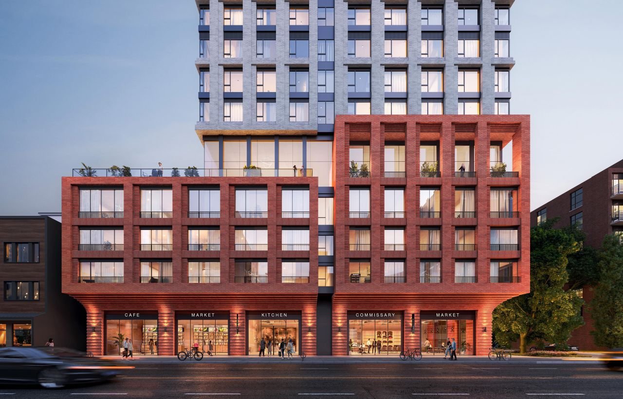
    I’m fairly confident that these posts did absolutely nothing. But today, I am happy to report that my friend and former colleague, Adrian Tarapacky (now VP of Development at Fairway Development Group), has submitted a rezoning application for a new tall building at 2475 Dundas Street West. The site is just north of Bloor Street West, at the intersection of Glenlake Avenue, and it’s exactly the kind of development I was wishing for when I wrote the above posts.

    Here’s a rendering of the proposed podium:
    And here’s the context:
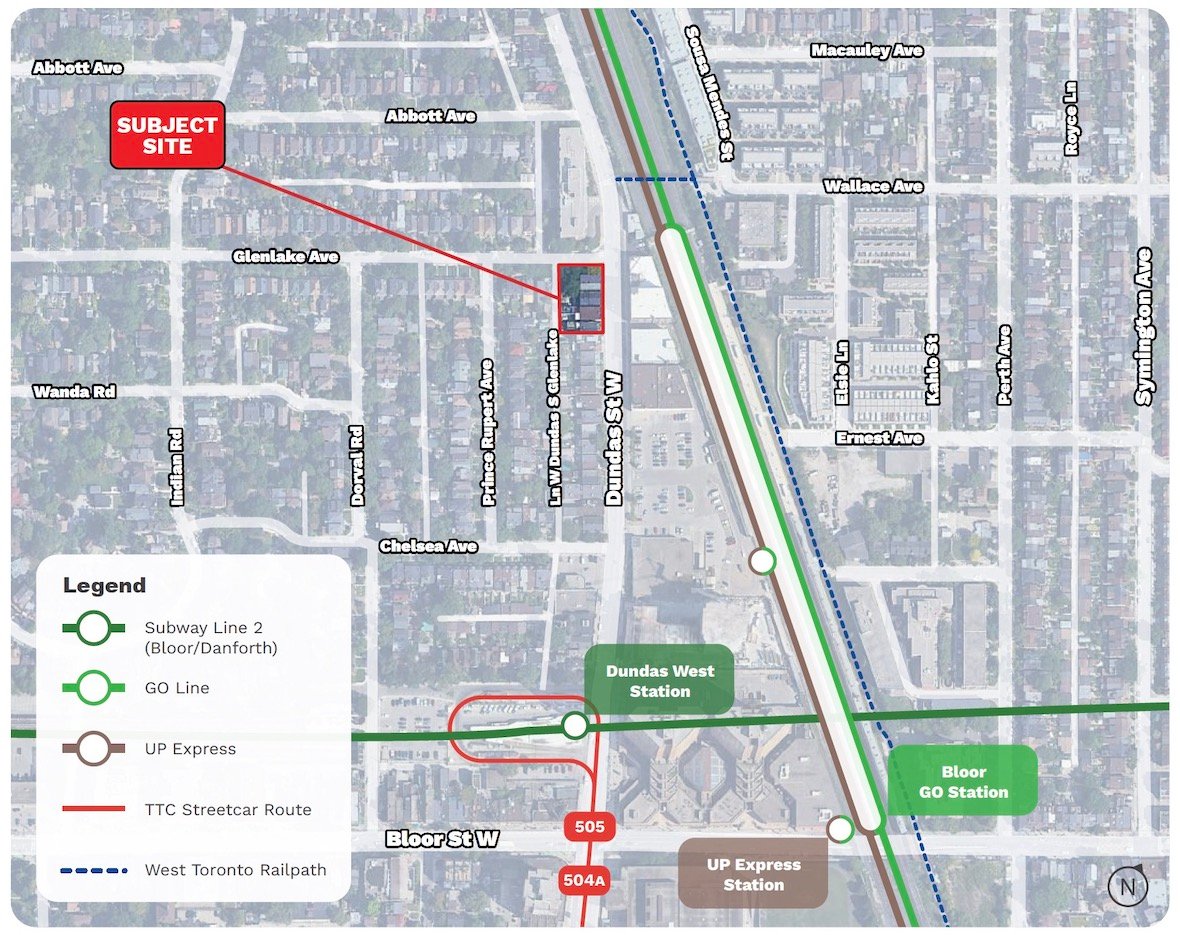
    Any developer will tell you that it’s not easy assembling this many parcels, which is likely one of the reasons why the street/area remains this underdeveloped. So great work, Adrian. I look forward to you bringing more vibrancy to my neighborhood and the second-best transit node in the country. I also know that you have impeccable taste in lunch sandwiches, so I look forward to seeing what happens with the ground floor retail spaces.

    If you’d like to learn more about the development proposal, here’s an article from UrbanToronto.

  • Not enough density next to transit

    Reece Martin is a foremost public transit critic based in Toronto. His YouTube channel, RM Transit, has over 284k subscribers and some 50 millions views. If you’re interested in public transit around the world, he is a great person to follow.

    He also writes a blog. And today, he published a post talking about the “5 places in Toronto that should have more density.” This, as we have talked about many times before, is essential. The way you get the most out of transit is to pair it with the right surrounding land uses. And here in Toronto, we have many instances of “not enough density next to transit.”

    For instance, the first place on his list is Bloor-Dundas West:

    The site already has streetcar serving on two routes, the subway, GO, and UP Express (which will be connected with the subway in the next few years — construction is underway), and lots more transit could show up in the future, from an extension of one of the streetcar routes to the Junction (with a transferway please), to the Ontario Line that will be primed for a second phase in this direction if development justifies it, to the potential for future Milton line train service. The site is arguably already the second-best served for transit in the country after Union, and could be made much better in short order.

    Hang on this last sentence for a second: the second-best transit node in the country. That’s an incredible asset! Now consider the area’s land use plan (red is mixed use and yellow is low-rise neighborhood in Toronto’s Official Plan):

    Other than the mixed-use triangle wedged between Dundas West and the rail corridor, the area looks pretty similar to much of Bloor Street in this city: mixed-use along the major streets and low-rise neighborhoods everywhere else.

    We know why this is the case; it is about maintaining the status quo. But it is a suboptimal way in which to try and create transit-oriented communities. We need more density, and we need to start thinking radially instead of linearly. So here’s what a 500m walking radius looks like around Bloor-Dundas West and its two closest subway station neighbors:

    The important thing to pay attention to in this diagram is all of the yellow that falls within each radius. This is land that ought to be zoned mixed-use, but that we have instead decided to make low-rise and single-use. If our objective is to create more walkable, sustainable, and vibrant transit-oriented communities, this is not the way.

  • Traffic signal inequality

    image

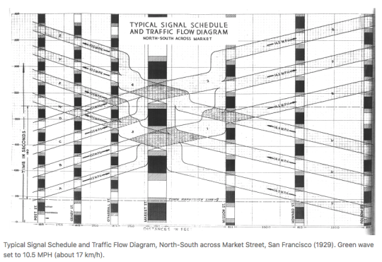
    David Levinson, who is based Sydney and authors the Transportist – a blog you should follow if you don’t – has a recent post up about signalling inequity and “how traffic signals distribute time to favour the car and delay the pedestrian.” In it he provides some background into traffic signal coordination (introduced in New York City in 1922), as well some some suggestions for how we could and should be prioritizing pedestrians.

    Here is an excerpt from the article:

    There is a reason that traffic engineers don’t automatically allocate pedestrian phases. Suppose the car only warrants a six second phase but a pedestrian requires 18 seconds to cross the street at a 1 meter/second walking speed. Giving an automatic pedestrian phase will delay cars, even if the pedestrian is not there. And there is no sin worse than delaying a car.  But it also guarantees a pedestrian who arrives just after the window to push the actuator passes will wait a full cycle.

    Sometimes pressing the walk button appears to do nothing. I suppose that’s why some cities call it the “placebo button.” And in other cases if you don’t press the walk button you’ll never get a walk sign. That’s usually a strong indicator that you are located in an environment not intended for pedestrians. David’s article also has me curious about the relationship between traffic signals/pedestrian phases and urban form. I bet you could tell a lot about the latter simply by understanding the former.

    Image: Transportist

  • Rethinking downtowns to improve urban mobility

    Jarrett Walker of Human Transit recently published an interesting post talking about downtowns. His argument is that we shouldn’t be planning our transit networks around the traditional notion of a single-centered city.

    Here’s a snippet:

    So growing a single downtown isn’t the key to becoming a great transit city. Quite the opposite, it’s best to have a pattern of many centers, all generating high demand, and supporting balanced two-way flows between them that let us move more people on less infrastructure.  This is the great advantage of Paris or Los Angeles or the Dutch Randstad over Chicago or Manhattan.

    Now, there are many cases where a singular economic center still dominates an urban region. See downtown Toronto. And many will argue that the current economic environment is creating more, rather than less, concentrated urban spikiness.

    But at the same time it is quite clear that many of our cities have shifted away from a monocentric model to a polycentric one. 

    I mean, just look at all employment nodes that have developed across the Toronto region. The idea that everyone comes downtown in the morning and then leaves in the evening has become an anachronism for many. Early in my career I spent 4 years commuting from downtown to the suburbs.

    So what is happening is that our cities need to start performing more like point-to-point networks. This isn’t a new thought. But it’s a lot harder to execute on compared to what many cities have been used to. 

    You need a critical density of both residents and employers and the right kind of connectivity to create a true “mobility hub.” In Toronto, you could argue that we really only have one of those and it’s centered around Union Station.

    But I think that will change for many cities. And when we do get it right, we will be doing a lot to improve the crippling traffic congestion that so many of our cities are suffering from.

  • Target is coming to Toronto’s South Core

    Yesterday news broke that Target is opening a two-storey, 145,000 square foot store at the base of a new mixed-use development in Toronto’s emerging South Core neighborhood. The site is at the north east corner of York Street and Harbour Street. And the larger development, called Harbour Plaza, will include a 35 storey office tower and 2 residential condominium towers at 65 and 69 storeys.

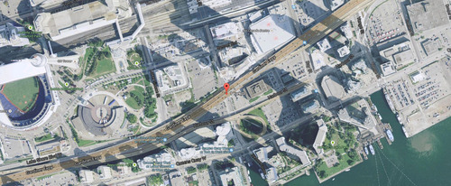
    Here’s the location map:

    image

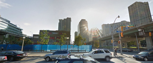
    And here’s the site looking east from York Street:

    image

    This is going to be huge for Target. The amount of current and proposed density within a short radius of the site is mind boggling. In addition to Harbour Plaza itself, look at what’s planned for 1 Yonge Street.

    Plus with Union Station next door, I dare you to try and find a better connected mobility hub in the region. Now all of a sudden that retail radius gets even bigger. I can easily imagine suburbanites picking up a few things before they hop on a GO train (our regional rail system) and head home.

    As of right now, they’re also the only game in town, as far as big box stores in the central core are concerned. But I wouldn’t be surprised if we see a competitor emerge alongside the 1 Yonge project. The site is big enough for one and Walmart isn’t going to want to get shut out of the area.

    My only hope is that, from an urban design standpoint, the project is able to enliven and give back to Harbour Street. Right now it’s an arterial road with really no redeeming urban qualities. But with the York Street off-ramp being relocated and the park underneath it being expanded, now is the time to really transform the area.

    Let’s hope Harbour Plaza does that.