
Daily insights for city builders, delivered every morning at 6 AM ET. I’m Brandon Donnelly — a Toronto-based real estate developer and founder of Globizen. I’ve been writing here since 2013.

Tag: la rambla

  • How do you make a street less touristy?

    La Rambla is arguably Barcelona’s most famous street. It’s a tree-lined street that runs 1.2 kilometres from the Plaça de Catalunya in the north to Port Vell in the south. Its origin dates back to the 15th century when the original stream was drained and the semblance of a street started to emerge.

    In the centuries that followed, the street came to serve as an important anchor for urban life in Barcelona. It provided a spine of open space within a dense medieval fabric of narrow streets. But alongside the rise of Barcelona as a global tourist destination, the street came to be seen more as a place for tourists than as a place for local urban life.

    This desire to create more “sustainable tourism” is one of the impetuses behind the ~€56 million revitalization project that is currently underway and is expected to be completed in 2027.

    But this raises a fascinating city-building question: How do you actually make a street less, you know, touristy? Tourists like visiting Barcelona and walking on this street, and so aren’t business owners going to just naturally cater to them? And aren’t landlords just going to rent to whoever will pay the highest rents?

    Here’s some of what Barcelona is doing:

    • Transversal flows: This one is fascinating to me. It was found that tourists tend to walk the street longitudinally (up and down), whereas locals tend to walk it transversally. In other words, locals are more likely to cross it coming from one of the surrounding neighbourhoods. The new design now privileges these more local flows.
    • Expanded pedestrian zones: Car traffic is being reduced to one 3.5-metre lane in each direction. This frees up more space for pedestrians, which is expected to help with overcrowding.
    • Room for culture: Dedicated spaces are being created to allow for more cultural programming. This is also part of a broader strategy to elevate the kind of tourism that the city receives.
    • Commercial licensing restrictions: As I understand it, the city is actively working to limit the licenses given out to souvenir shops (and the like) along the street. A meaningful amount of retail is also housed in kiosks and stands within the public right-of-way, where the city has even greater control.
    • Mercat de la Boqueria: One of the main anchors on La Rambla is the publicly owned market. But over the years, the product mix started to skew toward ready-to-eat foods and other to-go products designed for tourists. New restrictions have been put in place, or will be, that cap tourist-oriented offerings at 50%, allowing more space for local shopping needs. Interestingly enough, I have read that the merchants were in favour of this cap because the emphasis on tourist products was driving down margins. You instead want people coming in and grocery shopping for their families.

    These are just some of the initiatives that are being undertaken to rebalance La Rambla and find a more sustainable equilibrium between tourists and locals. It also dovetails with some of the other broader moves that Barcelona has implemented, such as its short-term rental ban and the right of first refusal (ROFR) that it enjoys over certain buildings and homes in order to grow the city’s public housing stock.

    It’ll be interesting to evaluate the effectiveness of these moves once the street is complete. La Rambla has many centuries of history and it has always evolved alongside Barcelona. Today is no different.


    Images from Barcelona City Council
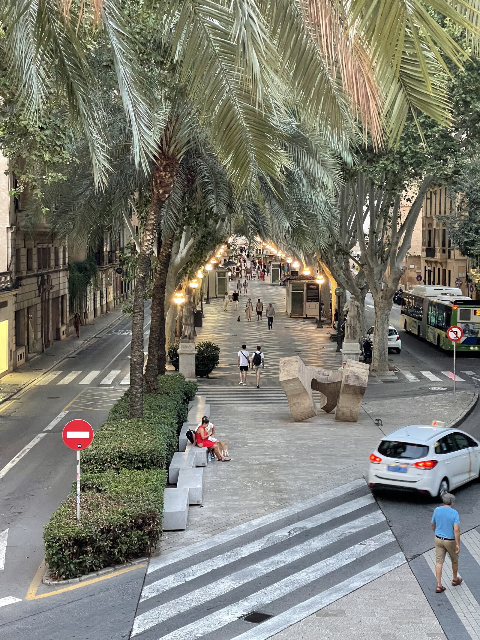
  • La Rambla

    It’s hard to think of Barcelona and not think of its famed street, La Rambla. But this same street design (and name) also appears in other cities throughout Spain. The above two streets are in Palma. The first is also called La Rambla (which is supposedly derived from an old Arabic word meaning sandy riverbed) and the second is called the Paseo del Borne. Both follow the exact same urban design principles. They’re broad tree-lined streets with a large center median dedicated to only pedestrians. All car traffic is relegated to the sides. What’s great about this design is the following. One, it reallocates public space according to who uses it the most (i.e. pedestrians). Two, it consolidates the main pedestrian realm (in lieu of just having larger sidewalks on either side of the street). And three, it establishes a clear hierarchy for the street. Pedestrians are most important here, and that’s why they get the center position. It’s surprising that more cities don’t adopt this same design.

  • London to pedestrianize Oxford Circus

    I was just reading about London’s plans to pedestrianize Oxford Circus with two new semi-circular pedestrian piazzas (pictured above). And it reminded of two things.

    One, there are silver linings to this pandemic. And one of them is that it has forced us to rethink how we allocate public space and how we engage with it. It is incredible seeing Toronto right now with so many outdoor patios in full swing. Why eat inside when you can eat outside? We should have been doing this all along.

    Two, the transformation of Toronto’s Yonge Street cannot happen fast enough. We are sorely missing a pedestrianized spine through the middle of our downtown. This portion of Yonge Street currently looks like shit and I know that we can do much better.

    Think La Rambla in Barcelona. Grafton Street in Dublin. Lincoln Road in Miami Beach. These are the streets that seem to always draw you in. They are places where public life can play out. I’m pretty sure that I have never once visited any of these cities and not walked these streets.

    Thankfully Yonge Street’s transformation is underway. So let’s make it truly remarkable and one of the most beautiful streets in the world. That should be the bar we set for ourselves.

    Image: Westminster City Council

  • Reimagining Toronto’s University Avenue

    If I have learned anything from this pandemic it is that, when push comes to shove, Torontonians will eat pretty much anywhere. On sidewalks. On streets. In white tents that masquerade as outdoor dining. And in many other little urban crevices.

    I am only half-joking, because the reality is that this pandemic has pried us away from the status quo and forced us to reconsider how we allocate and how we occupy many of our public spaces. There will be some positive outcomes on the other side of this.

    To that end, a new city building effort has just been announced here in Toronto. (Alex Bozikovic of the Globe and Mail wrote about it here in “Rebirth of the Promenade”.) The vision is called “University Park” and the team behind it includes the landscape architecture firm PUBLIC WORK, the non-profit Evergreen, and the Michael Young Family Foundation.

    What they want to do is transform Toronto’s University Avenue into something akin to La Rambla in Barcelona — except better:

    Our vision brings together patches of public green space that are currently disconnected and inaccessible in order to create a signature destination in the centre of our province’s capital. By making minor adjustments to the existing roadway on University Avenue and converting only 9.5 acres of city-owned asphalt into native landscape, pedestrian walkways, bike paths, and cultural installations, we can create a 90-acre park that spans from Queen’s Park all the way to the waterfront.

    It’s about time. My only request is that they include small sidewalk crevice where I might be able to sit and enjoy a chicken burrito and a glass of wine. To learn more about University Park and to subscribe to their newsletter, click here.

    Image: PUBLIC WORK