Daily insights for city builders, delivered every morning at 6 AM ET. I’m Brandon Donnelly — a Toronto-based real estate developer and founder of Globizen. I’ve been writing here since 2013.
To put things into perspective, consider that the downtown core (including King West, King East, and the Portlands) is estimated to be responsible for 51% of the entire wealth generated in this city. And yet its physical area is easily less than 10% of the entire city (which is about 630 square kilometers).
When I was working on my startup Dirt last year, one of the things we spent a bit of time figuring out was how to classify buildings according to neighborhood. Now, at first blush, this may seem like a fairly easy thing to do. You simply locate the building, figure out which neighborhood it’s in, and then tag it accordingly. But neighborhood boundaries and definitions aren’t as clear cut as you might think.
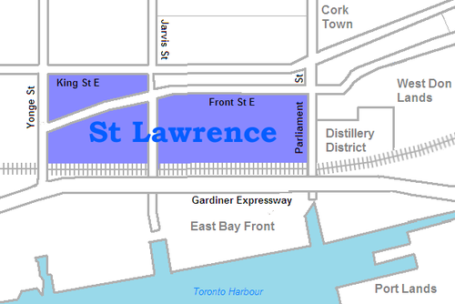
For example, a lot of you probably know that I live in the St. Lawrence Market neighborhood of Toronto. And indeed, if you look at this Wikipedia definition, I live in that area. But if you look at what they call it, it’s just: “St. Lawrence.” They also specify that it used to be called “St. Lawrence Ward”, but that today most people actually call it “the St. Lawrence Market.” So here you have an example of an evolving and changing name.
But then there’s the question of boundaries. According to Wikipedia’s definition, the north boundary is Front Street. This means that the North Market Building would be technically outside of the area and so would the Market Square condos. But I suspect that almost everyone would consider these two buildings to be part of the neighborhood. So where exactly is the north boundary? Is it King Street? Or maybe by Front Street they mean that all buildings on the north side of the street are included.
If you look at the city’s official neighborhood list (which is built from Statistics Canada Census Tracts) you’ll find a completely different boundary and name. According to this list, I live in the “Waterfront Communities–The Island” neighborhood. Obviously nobody, other than maybe somebody who deals with census data, would have any idea what this area is. But it’s how the city tracks its demographic data.
What this begins to show you is that neighborhood definitions and boundaries aren’t as black and white as they might initially seem. And it’s partially because cities themselves are always in flux. New neighborhoods emerge and old ones reinvent themselves. And as that happens, people start introducing new names and new terminologies.
When I was about 19 years old, people in Toronto used to say they were going out “on Richmond and Adelaide.” Since then, gentrification has pushed many of the bars and clubs out of that area. So people instead go out “on King West” or “on Ossington.” And as people begin to use those terms and identify with an area, new brands are created. Ask anybody who lives downtown and I bet they’ll tell you that King West has its own unique personality and even a type of person who typically lives there. This is an on the ground type of awareness though, which doesn’t get captured in census tracts.
The other reason neighborhood boundaries can be so fuzzy is because we – the real estate community – are constantly trying to manipulate them for our own benefit. I’m indifferent to the fact that this happens, but it is a reality. Think about how much the neighborhood of Yorkville has been stretched from its original roots north of Bloor Street. If a neighborhood has a good brand, agents and developers will naturally try and leverage it. Homeowners do it all the time too. Would you prefer to say that you live in Seaton Village or the Annex?
Ultimately, we (my Dirt cofounder and I) decided that neighborhood definitions and boundaries needed to be fluid. They needed to dynamically adjust with the market and come from as many people as possible on the ground. Because at the end of the day if the official documents say one thing, but the majority of city residents believe another, then that official boundary and definition are probably out of date. The crowd wins here.
We liked this approach because it was organic – just like cities.
Last week Toronto City Council voted to support planning staff’s recommendation to approve the landmark Mirvish + Gehry development on King Street West in the Theatre District.
The revised design now includes 2 towers (as opposed to 3) at 82 and 92 storeys tall. As a result of this change, 3 of the 5 existing buildings on the site will now be retained. I think this represents a good balance between (historic) preservation and progress.
If you’re interested in a bit more of the backstory, Toronto Life published an article today called David Mirvish on the Edge. It talks about his father (Ed Mirvish), his upbringing, and how he got into the real estate development business.
Encompasses Draper Street, which is a heritage designated street
Approximately 500,000 square feet of retail space
More than 1,000,000 square feet of commercial office space
More than 1,000,000 square feet of residential space
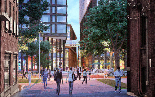
From the early renderings, the project looks incredibly promising. Wellington Street East is a great street, but the south side of it is currently a mess. With a new lining of well designed midrise buildings on it, the street could be spectacular.
I like that there seems to be a focus on creating a fine grain network of streets and laneways. And it’s making me think that this stretch of Wellington could work really well as pedestrian only. Both ends of the street terminate in a park (Victoria Park on the west and Clarence Square on the east), which would make it a really beautiful (dumbbell shaped) urban space.
This is something Toronto doesn’t have today. This could be our opportunity.