Daily insights for city builders, delivered every morning at 6 AM ET. I’m Brandon Donnelly — a Toronto-based real estate developer and founder of Globizen. I’ve been writing here since 2013.

Tag: king streetcar

  • The King Street Transit Pilot has started

    Back in January 2016, I wrote about Toronto’s ambition to transform King into a “transit first” street across the downtown core. 

    The King streetcar is the busiest surface transit route in the entire city (65,000 riders / day on average) and it was – and continues to be – my opinion that the route was broken. Something had to be done.

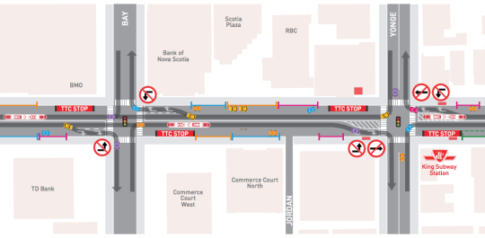
    Well, that something is now happening. The “King Street Transit Pilot” officially started on Sunday, November 12, 2017 at 7am. Here are some of the key changes, many of which are also depicted in the above image:

    – No more on-street parking in the pilot area.

    – Cars can no longer turn left or drive through the intersections of the pilot area (except for taxis picking up drunk people from 10pm to 5am).

    – Cars must now follow a right-in/right-out approach. They can turn right onto King, but then they have to turn right off of King at the next intersection.

    – Most of the streetcar stops have been moved to the “far side” of each intersection. That is, after the lights. Passenger waiting areas are now in the curbside lane and protected by jersey barriers.

    – Cyclists can go through the intersections of the pilot area. “Bike boxes” have been added to intersections where there are north-south bike lanes to help with turning left.

    As to be expected, some people are upset about the above changes. There are also concerns that drivers aren’t going to obey the rules and continue to drive through the intersections in the streetcar lane. But this is a pilot project. It’s about learning and adjusting.

    It’s also important to keep in mind that King has at least 3x more transit riders than cars. This pilot is about figuring out how to best optimize the street so that it moves the greatest number of people as efficiently as possible.

    I’ll report back here on the blog once the pilot has settled in and there is a better understanding of its impact.

  • How permissive zoning created Toronto’s King-Spadina district

    image

    Over the weekend, Marcus Gee of the Globe and Mail published a terrific article about Toronto’s King-Spadina district and how “condos conquered a rundown district of the city.” (This post will argue that condos were not the catalyst, but an outcome of other changes.)

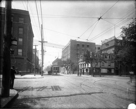
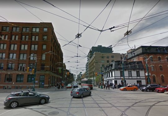
    The image at the top of this post (City of Toronto Archives) is the intersection of King Street and Spadina Avenue around the early 1900s. And here is roughly that same view from May 2016 (Google Streetview):
    image

    From this perspective, it may look like not much has changed. The buildings at the two corners are still there, although their uses have changed. The streetcars are still running, although we now have slightly newer machines. And there are overhead lines providing a canopy across the intersection.

    But as Gee points out, the reality is that in recent years King-Spadina has arguably seen more change and development than any other precinct in the city:

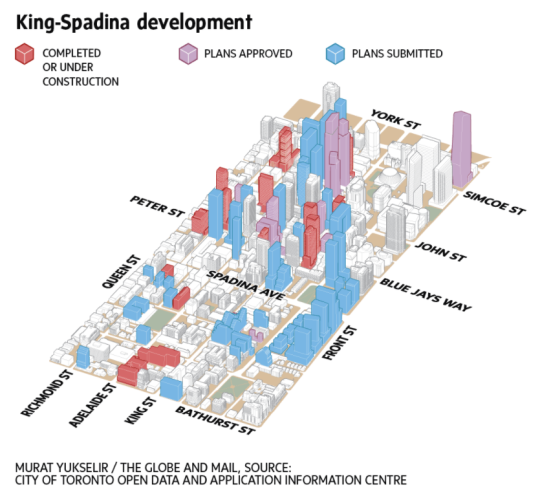
    No fewer than 99 projects have been built, approved or pitched since 2004. That’s one quarter of the total for the entire city and more than the count for two vast suburban districts – Scarborough and Etobicoke – combined. King-Spadina is overtaking even high-rise hubs such as Yonge and Eglinton in midtown Toronto and the Bay and Yonge corridors downtown.

    Below is a diagram showing the built form of that change.
    image

    But as we talk about this massive change, I would argue that this didn’t happen by accident. 

    Gee starts his piece by saying that “cities have an endless ability to evolve, to rebound, to reinvent and regenerate themselves, sometimes in ways that would astonish generations past.” I would add one word: Successful cities have an endless ability to evolve.

    King-Spadina has indeed reinvented itself many times. Prior to its current iteration, it served as a manufacturing district and as the center of Toronto’s garment industry. But from the 1970s through to the early 1990s, the area fell into decline as its manufacturing base left.

    The game changing moment happened in 1996 when “The Kings” – which includes the areas around both King-Spadina and King-Parliament – were redesignated as “Regeneration Areas.” The overarching goal was to deregulate away from single-use industrial zoning and allow the area’s buildings, both old and new, to take on almost any use.

    Now all of a sudden it was possible to have light industrial, commercial, entertainment, retail, residential, and live/work uses all mixed together. And with the bones already in place, the market responded. 

    In my view, it is these earlier changes that laid the groundwork for what has become one of the most exciting neighborhoods in the country.

    However, today some are worried about whether or not this is too much of a good thing. And I am sure that many would like to blame developers for piling up in this neighborhood. Why continue to build here when there’s lots of land elsewhere?

    King-Spadina is a perfect example of what Richard Florida would call “winner-take-all urbanism.” There are powerful clustering forces at play both globally and locally in our cities. And so there are real economic reasons for why King-Spadina has seen more development than Etobicoke and Scarborough combined.

    Permissive land use policies and the right building stock may have kickstarted things, but now economies of agglomeration have taken over. Retailers, restaurants, clubs, tech companies and people, among many others, are now fighting for space in this area for the same reason that Toronto’s garment industry once felt the need to cluster here. There are tangible benefits to doing so.

    What people are effectively asking today is at what point do we start to see diseconomies of agglomeration. This is an important question and one that needs to be actively managed. 

    Without getting into any of the details, I believe that the King Street Pilot Study – which puts transit first along the King corridor – is one very appropriate answer to this question. It is a direct response to diseconomies of agglomeration, in this case traffic congestion.

    But there are important corollaries to this question that are also worth considering: How do we now create more King-Spadinas and how do we create more broad-based and inclusive urbanism in the face of these powerful clustering forces? These are questions that go well beyond King-Spadina, but there are lessons to be learned from the successes seen on the west side of downtown Toronto.

    Images via The Globe and Mail and Google Street View

  • 3 pilot options for Toronto’s King Street corridor

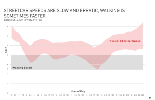
    Anyone who has ridden Toronto’s King streetcar during rush hour can tell you that the service is broken. It’s unreliable. It’s overcrowded. And during peak times it can be faster to walk. Chart below.

    Part of the problem is a misallocation of resources. Only 16% of the people who use the corridor are in cars. And yet 64% of the physical space is allocated to drivers.

    Not surprisingly, this creates a bottleneck for the ~65,000 transit riders who use the service daily. (Busiest surface route in the region.) We are not optimizing for the right variable.

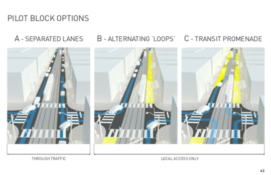
    It’s for this reason that the city is working on a rethink of the corridor. I wrote about this initiative last year, but earlier this week it got a bit more real with the release of the following 3 pilot block options.

    The plan is to launch a pilot sometime this fall (2017). This is good news. 

    If you’d like to go through the full King Street Pilot Study Public Meeting presentation, you can do that by clicking here. The above images were taken from that presentation.

  • Toronto’s King Street to be transformed into a transit + pedestrian corridor

    Take The Car by Jason Cook on 500px.com

    https://500px.com/embed.js

    I try not to focus on local Toronto issues this much, but this morning an important initiative was announced and it’s blowing up my Twitter feed.

    By spring 2017, the city hopes to have a pilot project in place that will transform King Street – running from Liberty Village in the west to the Distillery District in the east – into a priority-transit and pedestrian corridor.

    This isn’t to say the street will be closed to cars. I would imagine that at least 1 lane would remain for cars going each way. Instead it will be redesigned to prioritize transit, pedestrians, and cyclists.

    So why is this exciting?

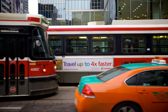
    The King streetcar is currently broken. If you’ve ever taken it across downtown during rush hour, you know exactly what I mean. It’s infuriating. You might as well be crawling on your hands and knees. One of the goals of this initiative will be to get it working again. Good.

    The shoulders of downtown – along King West and King East – are seeing some of the greatest intensification in the region. So much that it’s common for people in this city to complain that Toronto misplanned it all by allowing this development before the transit was there. Well, this is a quick and inexpensive way to get the transit there. Remember that when the inevitable “war on car” rhetoric ratchets up over the next year.

    The project will be deployed, first, as a pilot project. That will allow the project team to test and iterate. It has also become the way you get things approved in cities. You first make them temporary. 

    But I am certain that we will quickly discover how necessary these changes were.