Daily insights for city builders, delivered every morning at 6 AM ET. I’m Brandon Donnelly — a Toronto-based real estate developer and founder of Globizen. I’ve been writing here since 2013.

Tag: infographic

  • Net flow of households across US regions

    These are a set of diagrams taken from a recent WSJ article talking about how, “the pandemic changed where Americans live.” I know that this is a topic that gets a lot of air time (both here on the blog and elsewhere), but these diagrams do a good job of showing the flow of people, as well as how things may have changed/accelerated since 2018.

    These diagrams also remind me of the work of Charles Joseph Minard. A French civil engineer, Minard is best known for his contributions to the field of information graphics, and in particular his flow maps. His most famous piece of work — which I happen to have hanging at home — is his depiction of Napoleon’s losses during the Russian campaign of 1812.

    The map itself is from 1869 and is packed full of information. It shows the number of Napoleonic troops as they left for Moscow, the distance they traveled, the outside temperature (the French weren’t properly prepared for the cold), latitude and longitude, the direction of travel, and the location of the troops relative to specific dates.

    The point of the diagram was really to show how disastrous this campaign was for Napoleon. The thick beige band on the left is showing over 400,000 troops setting out. But by the time they reached Moscow — which, by the way, had been abandoned before their arrival — only about 100,000 troops were left.

    The thin black bar on the bottom is showing how many troops ultimately remained and returned at the end of the campaign — the number was only about 10,000. So the vast majority of Napoleon’s troops perished. Supposedly over half either starved or froze to death.

    Some 150 years later, and we are still using flow charts to clearly depict the movement of people and things.

  • Beer over water and the contributions of John Snow

    The work of John Snow is instrumental to the field of epidemiology. In the mid-19th century, during what was the third major outbreak of cholera, he created the following map showing the clusters of cholera cases in London’s Soho neighborhood. Stacked rectangles were used to indicate the number of cholera cases in a particular location. This was a major breakthrough for the fight against cholera because, at the time, it wasn’t clear what was causing it. According to Wikipedia, there were two main competing theories. There was the miasma theory, which posited that cholera was caused by bad particles in the air. And there was the germ theory, which posited that cholera could be passed along through food and/or water.

    By mapping the clusters of cases, Snow discovered a concentration of incidents in around the intersection of Broad Street and Cambridge Street (now Lexington Street) where a water pump was located that drew water from the Thames. This led Snow to the conclusion that it was maybe a bad idea to offer up polluted river water as drinking water. And sure enough, when the pump was shut off and residents were directed to other nearby pumps, the incidences of cholera began to decline. The germ theory had proven to be true.

    The first time I saw John Snow’s map was in architecture school. Perhaps many of you have seen it as well. It is often used to illustrate the potential of visual representations to not only tell a story, but to teach the creator what that story actually is. In hindsight, it may seem obvious that polluted river water is something that we maybe shouldn’t drink, but it wasn’t at the time. This map helped people understand that. Today, we have far more sophisticated tools available to us, but we still have a lot to learn and we’re doing that every day — particularly during a pandemic.

    One other thing worth mentioning is that there are a few exceptions to Snow’s findings. Supposedly, many of the workers in a nearby brewery were able to completely avoid the cholera infection during the outbreak by only drinking their own brew. Some say it is because the brewery had its own water source, whereas others say it is because the brewing process — the water is boiled — kills the cholera bacteria. Either way, I think the moral of this story is pretty clear: when in doubt, choose beer over water.

    Map: Wikipedia

  • In search of affordable housing

    Earlier this week I stumbled upon this entertaining article from the Guardian talking about how expensive housing is in London. The author’s tongue-in-cheek suggestion was to setup a new miniature London in the middle of nowhere where everyone could flock for affordable housing, but where many of London’s attributes could be exported: “We can all refuse to wear socks and sell each other overpriced cocktails in jam jars.”

    All joking aside, the article is yet another reminder that big global cities are expensive places to live. And in these cities, one of the most precious commodities is, quite simply, personal space. That’s why a garage in London can sell for £550,000 and why a 35 square foot storage cage in New York can sell for $75,000

    But affordable housing is not the reason why people want to live in places like London and New York. If it were, they wouldn’t be coming. Instead, they come for lifestyle, wealth creation, and the dating market – among other things. However, at a certain point, usually when they form families and start to need/want more space, they start looking around.

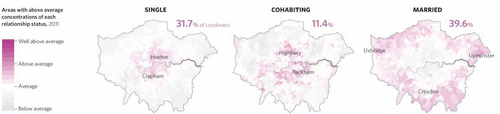
    Here’s an infographic via the Atlantic showing how relationship status impacts where people tend to live in London. The purple areas indicate an “above average concentration” of a particular relationship status. As you can see, single people tend to live in the core of the city, and when they get married, they move out to the periphery. Intuitively, this probably makes sense to you.

    image

    However, I’m always curious as to whether this trend happens more because of consumer preference (people don’t want to raise kids downtown) or because of economic necessity (they can’t afford anything beyond a shoe box apartment). Because if it is largely out of economic necessity (and the Guardian article would suggest it is), then we’re not creating the inclusive cities and neighborhoods that all city builders like to talk about.

    So how do we get better at this?

    In my view, and I’ve argued this before, the first step should be about improving supply. That is: get more housing built. And the way to start doing that is to make land available and improve the approvals process for new developments. In a recent McKinsey report, they referred to my first point as “unlocking land.”

    “Land cost often is the single biggest factor in improving the economics of affordable housing development. It is not uncommon for land costs to exceed 40 percent of total property prices, and in some large cities, land can be as much as 80 percent of property cost.”

    The reason this is important is because most big cities operate with massive supply deficits. There simply isn’t enough housing. And so if you can address that at a fundamental level, you can actually do a lot to start improving affordability.

  • What should San Francisco do with the Tenderloin?

    image

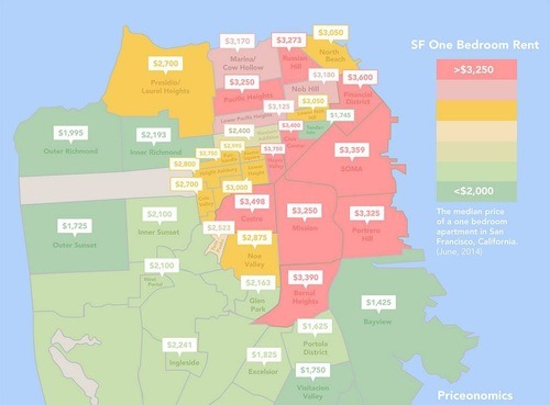
    Recently Priceonomics posted a piece on San Francisco’s “rent explosion.” In it, was the infographic above showing the median rental rate for a 1 bedroom apartment in the city. The most obvious takeaway is that San Francisco is real expensive. In the core of the city, you’re easily looking at $3,000 per month.

    That is with one exception: the Tenderloin (the green area just northwest of SOMA in downtown). The first time I ever visited San Francisco, I actually stayed on the outskirts of this area, which is a neighborhood well known for seediness, homelessness, crime, drug trade, strip clubs, and so on. And it was actually named after a similar neighborhood in New York that was also a center of vice in the late 19th and early 20th centuries.

    But when I saw this diagram, I immediately asked myself: How could it be that the Tenderloin was holding out so well against the forces of gentrification? How is this island of seediness being preserved in the center of downtown? Particularly in a city like San Francisco where there’s a perpetual housing supply shortage and lots of wealth. The Tenderloin has some of the lowest rents in the city.

    So I tweeted the good folks at Priceonomics and they responded with this article. It’s a few pages long, but the reasoning seems to come down to the following: active community groups that fought to keep developers out of the area (and that also own many of the buildings), downzoning, and a high percentage of rooming houses. According to that same article, the Tenderloin contains approximately 100 single room occupancy residential hotels (or SRO’s as they’re called). These were initially built to house the city’s transient and seasonal population after the great fire of 1906.

    So it would appear that there are some significant barriers to entry.

    But at the same time, it generally seems like a bad idea to concentrate poverty, homelessness, drug users, and so on. Interestingly enough, the article talks about how when the Bay Area’s transit system went on strike for a period of time, the supply of drugs actually dried up in the Tenderloin. This underscores how regional the drug business is, but also makes me think that dealers are almost surely benefiting from the clustering of their client base.

    In any event, this is a much larger problem than just a real estate development one. I don’t know what the solution should be, but I’m pretty sure that things are being made worse by concentrating everything in one neighborhood and by rising income inequality in the city. Inequality seems to lead to all kinds of negative externalities and, from my experience, mixed-income neighborhoods perform better than 100% poor ones.

  • How many households in Canada live in a condominium?

    Click here to zoom in / download a copy

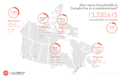
    I’ve been meaning to introduce infographics and diagrams into my posts at ATC for quite some time now, so I’m excited to introduce the first one: How many households in Canada live in a condominium? I hope to make this a regular feature.

    While a lot of the new development happening in Canada is condominium – particularly in cities like Toronto and Vancouver – the vast majority of households in Canada still live in non-condominium dwellings. Only 12.1% of households are condominium households, which could be high-rise, low-rise, row-housing, or other, according to Statistics Canada.

    Perhaps not surprisingly, the Vancouver CMA has the highest percentage of condominium households at 31.4%. I would have expected Toronto to come second, but Calgary (20.4%) actually takes that position (probably) due to an abundance of low-rise condominiums (38.8% of all condos in the CMA). However, Toronto has, by far, the highest percentage of high-rise condominium households at 67.4%. This isn’t surprising to me.

    All of the data for this infographic was taken from Statistics Canada and the total number of households in each Census Metropolitan Area (CMA) was assumed to be “occupied by usual residents.” StatsCan defines this as households that are permanent as opposed to ones that could be second homes and so on.

    I hope you like the first ATC infographic.