Daily insights for city builders, delivered every morning at 6 AM ET. I’m Brandon Donnelly — a Toronto-based real estate developer and founder of Globizen. I’ve been writing here since 2013.

Tag: flooding

  • Toronto got flooded out today

    It rained a lot today. According to Environment Canada, Toronto’s Pearson Airport saw 97.8 mm of rain fall before 2 PM. This is the fifth rainiest day on record; the record being July 8, 2013, which saw 126 mm fall. But today feels a lot like it did in July 2013. The same rivers, streets, and underpasses flooded. People needed rescuing. Cars got marooned. And more than 167,000 customers were left without power. I lost power in the Junction around lunchtime and it didn’t come back on until just before 7 PM. That really hurt productivity, although I did manage to get in a workout during the outage.

    Sadly, all of this is expected. The thing about air is that its ability to hold water depends on its temperature. For example, according to Nasa, a given volume of air at 20°C can hold 2x the amount of water vapor compared to air at 10°C. So as the earth’s atmosphere warms, it is automatically going to hold more water vapor, and that means the potential for bigger and more severe storms. Some scientists predict that for every 1°C increase in atmospheric temperature, we should expect precipitation intensity during extreme storms to increase by about 7%.

    This means that flood and water management are only going to become increasingly more important to all cities — not just the most vulnerable cities like Miami. And it’s going to require constant adaption as we figure out how to best manage the climate damage we’ve done. Of course, it’s easy to want to do something about this on days like today when everyone is sharing videos of flooded streets and floating cars. But the trick is continuing to do something about it once most people have forgotten what July 16 was like.
  • Redfin experiment shows how home buyers react to flood-risk data

    This is a fascinating little experiment:

    From Oct. 12, 2020 to Jan. 3, 2021, Redfin ran an experiment on 17.5 million of its users across the US. As prospective homebuyers entered the site, Redfin assigned them randomly to either a group that was shown flood-risk information on each property or a group that was not.

    The flood-risk scores came from First Street Foundation, a climate and technology nonprofit that works to make climate hazards more transparent to the public. In June 2020, First Street published the first public maps that revealed flood risk for every home and property in the contiguous US. 

    First Street scores properties on a scale of 1 to 10 based on the likelihood that they will flood in the next 30 years (which is assumed to be a typical mortgage term). A score of 1 means the property has “minimal” risk and a score between 9-10 is considered “extreme” risk.

    So what happens once you start showing people flood-risk information? They, not surprisingly, start systematically looking for safer properties. After one week of users being exposed to this new information, prospective buyers who were previously looking at “extreme” homes started looking at homes that were about 7% safer.

    After 9 weeks, these same “extreme” home buyers were looking at properties that were about 25% less risky. And for some buyers, in particular those working with a Redfin agent or partner, their flood-risk tolerance dropped by over 50%. (Embedded in this data might be a sales pitch for working with a knowledgeable Redfin agent or partner).

    Also interesting is the fact that below “severe” flood risk (a score between 7-8), there was very little change in behavior. “Major” flood risk, it would seem, isn’t all that concerning to most buyers. It needs to be “severe”. Nevertheless, it is noteworthy that people will in fact make behavioral changes when presented with clear climate-risk data.

  • New York City is testing new “flex gates”

    I spent a good chunk of this morning talking and thinking about underground building details that most people (unless you’re in the industry) would never think to consider. This is not a criticism on most people. I mean, I don’t know how iPhones are made. I just use and enjoy them. But when it comes to buildings, I’m paid to ask questions and understand how things work.

    There’s a lot of risk in the ground.

    You have to think about things like bearing capacity, environmental contamination (usually), hydrostatic pressure and, generally, how you’re going to manage water, particularly if you have a high groundwater table. Usually this last one is about making sure you’re keeping the water out. A pretty important detail both below and above grade.

    So when I came home tonight and saw the below tweet, I felt obligated to write about it.

    If you read the reply from NYC’s Metropolitan Transportation Authority, you’ll see that this is them testing something they call a “flex gate.” It is a flood barrier that allows them to seal off subway entrances in the case of a storm surge and they run these tests (shown above) for 4 hours at a time to make sure they’re installed property. This one was.

    Managing water is a big part of city building. New York City, Miami, Venice, and countless others know this all too well right now.

  • Holding back the sea, in Venice, maybe

    Venice has been keeping flood records for 150 years, though it is generally understood that the city has been regularly flooding since the very beginning. It usually happens between the fall and the spring and the earliest record is believed to be from the 6th century.

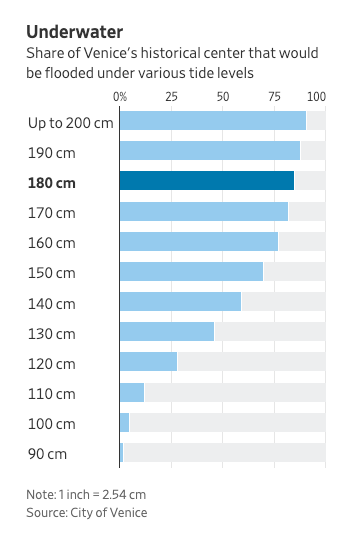
    This past week, Venice saw its acqua alta (or high water) peak at 187cm (6’2″) above its normal level. This is the second highest number on record and is just below its 1966 peak. At these numbers, about 80% of the historic center is underwater. Here is a chart from the WSJ explaining that:

    Venice has been working on a flood management project called MOSE since the 1980s. The name is an acronym, but there’s a deliberate biblical reference here. Remember when Moses parted the red sea?

    The project has been mired in engineering delays and corruption scandals, and so it’s not yet operational. If it were, it would have, in theory, protected the city this past week. 2022 is the anticipated completion date, but I don’t know if that’s realistic or not.

    The system consists of 78 mobile gates that fill with water and sit flat on the seabed when the tide is low. When a high tide is predicted, the gates are then to be pumped with air so that they rise (hinged on one side) and close off the three inlets that connect the Venetian Lagoon to the Adriatic Sea.

    As I was reading about this project and everything else that has been going on in Venice this past week, I became curious about how exactly the Dutch have been managing to hold back the sea. I mean, a big chunk of the Netherlands sits below sea level.

    If you’re also curious, here’s a video that explains how they do it.

  • The politics of flooding

    Do you believe that human action has caused and is causing negative outcomes with respect to the environment?

    The New York Times published a feature piece this week on the flooding of the US east coast. 

    Associated with the article is a fantastic infographic that shows all of the NOAA (National Oceanic and Atmospheric Administration) tide gauges up and down the eastern seaboard. It then zooms in to a few locations and shows mean sea level rise (in inches) since 1950 and the number of days of “nuisance flooding.”

    Here’s a sample screenshot:

    If you don’t feel like reading the full article, at least check out the infographic. The increase in nuisance flooding for some cities – such as Wilmington, N.C. (shown above) and Annapolis, MD – is astounding.

    What’s frustrating about the whole climate change debate is that it remains not only a debate, but an ideological debate. Here’s a quote from the article that stood out for me:

    “I’m a Republican, but I also realize, by any objective analysis, the sea level is rising,” said Jason Buelterman, the mayor of tiny Tybee Island, one of the first Georgia communities to adopt a detailed climate plan.

    In other words: I’m not supposed to think this way, but I do.

    Politics.

  • What sea level rise is doing to the urban landscape of cities

    Resiliency is an important topic in urbanist circles these days.

    New York is working on a 10 mile “Dryline” to protect itself from future storms similar to Hurricane Sandy. And Miami Beach – one of the most vulnerable cities in the U.S. to sea level rise – is frantically building pump stations and raising its seawalls, streets, and sidewalks.

    Here’s what the city’s public works director had to say via a Curbed article published about a week ago:

    Miami Beach is planning to spend upwards of $500 million over the next five years on the pump stations and street-raising projects. “We are quite certain we are going to buy ourselves another 30 years, and we are hoping we are going to buy ourselves another 50 years,” Carpenter said.

    According to Wired, sea levels off the coast of South Beach have risen by 3.7 inches since 1996. But over the last 5 years the high tide levels have had an average increase of about 1.27 inches per year!

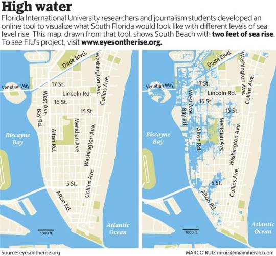
    This matters a great deal because of what South Beach would look like if sea levels increased by 2 feet (via the Miami Herald):

    It’s for this reason that Miami Beach has been working to alter its street elevations and install pumps – as many as 80 of them over the next 5 years – that quickly drain stormwater into Biscayne Bay. (The drains are equipped with backflow preventers so that the water leaves but doesn’t come back into the island.)

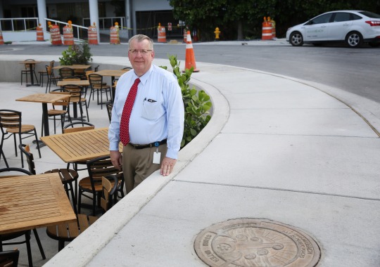
    Here’s an example of a raised street and sidewalk (via the Miami Herald):

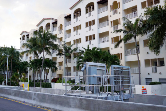
    And here’s an example of a pump station (via Curbed):

    All of this strikes me as necessary work for Miami Beach. But I also think it’s important to keep in mind that all of this is patch work – regardless of how necessary it is right now. 

    The bigger question is: what are we doing to stop sea level rise? That’s the only way we’re going to get to true, urban, resiliency.