Daily insights for city builders, delivered every morning at 6 AM ET. I’m Brandon Donnelly — a Toronto-based real estate developer and founder of Globizen. I’ve been writing here since 2013.
New York City is projecting that Lower Manhattan is likely to see more frequent flooding by as early as the 2040s. This could move to monthly flooding by the 2050s and daily by the 2080s. These time horizons may seem like a ways away, but I’m personally going to try my damnedest to see the 2080s.
In light of these projections, New York City released a new Financial District and Seaport Climate Resilience Master Plan at the end of last year. The plan is projected to cost somewhere between $5 to $7 billion and entails building out a new multilevel waterfront that extends the current shoreline into the East River by up to 200 feet.
Here are a couple of renderings:
The upper level will be elevated by about 15-18 feet (designed to protect against storms like Sandy) and the lowest level will be a continuous waterfront esplanade (designed to connect humans to the water). Overall, the plan encompasses about one mile of waterfront, running from The Battery to the Brooklyn Bridge.
City building take times. In the case of this plan, it is building for the next century.
Today was a historic day for Toronto, for Canada, and for the game of basketball in this country. The Toronto Raptors are world champions for the first time since their founding in 1995. Soak it in. Here is a photo that I took of the parade coming through the Financial District at around 2:30pm:
Some of the estimates going around are that 1 to 2 million people attended today’s championship parade. But 2 million seems like a lot, even though today was frenetic (see above photo, again). I mean, that’s 1/3 of the population of the Greater Toronto Area.
The fact that some of the “official” estimates also have a 1 million person spread tells me that, as of right now, we actually have no idea how many people were at today’s parade.
So that got me thinking: How do people count crowds? And are we using drones to do it, yet? Subway and rail ridership for the day — which surely spiked — will give us some indication. But definitely not the full picture.
It turns out that the typical approach to counting crowds is known as Jacobs’ Method. It was invented in the 1960s by a professor at UC, Berkeley, named Herbert Jacobs. He came up with the method while trying to count the number of students protesting the Vietnam War.
The concept is simple: It’s area x density. And permutations of his method usually use this same principle. What you do is take the area filled with people, break it up into a smaller grid, and then come up with a population density estimate for each square.
He had some rules of thumb for that. A light crowd was about 1 person per 10 square feet. And a dense crowd (such as a mosh pit or an NBA championship parade in Toronto) was about 1 person per 2.5 square feet.
Using this method and aerial photos of today’s parade, I would imagine that we could eventually get to a more precise estimate than 1 to 2 million people. But surely somebody has figured out how to program a drone (or other UAV) and do this even more accurately.
Crowd data is valuable information, particularly for political rallies and protests (I would imagine). If you know of a company doing this, please leave it in the comment section below. And if it doesn’t yet exist, well then, now you have a new business idea.
I came across an interesting discussion on Twitter last night about tunnels, bridges, elevated walkways, and Toronto’s elaborate (mostly) underground shopping complex known as the PATH. It’s the largest of its kind in the world.
Here’s the thing: the idea of pulling people off the street and into an underground shopping mall, runs counter to what many urbanists believe is the optimal outcome.
Below is a footnote I found in a 2006 research paper by Pierre
“The reluctance of urban designers and academics to engage the
dynamics of the underground is stunning. For almost 50 years, urban
designers, landscape architects and planners have longed for car-free
pedestrian environments that are safe, secure and accessible. From a
planning perspective, the Toronto underground may be the ultimate form
of attrition of the automobile on the urban landscape: there are no parking
lots, no asphalt, and no congestion. With its mass-transit accessibility, it is
an ideal pedestrian network. This reluctance may in part be attributable to
a prevailing attitude that privately-controlled underground shopping is
undesirable, at best dismissible. As self-contained environments, they are
perceived as lying outside the so-called public domain and that they kill off
street life. As a more legitimate form of collective space, street-level
activity located within municipal right-of-ways therefore receives much
more advocacy.”
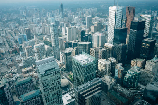
Of course, there is truth to the notion that activity gets concentrated below grade. When people visit Toronto’s Financial District for the first time, they’ll often ask: Where is the retail? And then you have to explain that it’s all underground and that we live like mole people from 9-5.
But despite this reluctance on the part of urbanists, people do seem to like it. When you’re marketing a building in the CBD, being PATH-connected is a feature, not a bug. I always joke that in the summer, I hate the PATH. But in the winter, I love it.
There’s also a feeling of hyper-connectivity during business hours in the PATH – particularly at lunch. You have everyone leaving their desks, descending from their towers, and mixing all about in a dense pedestrian-only network. It’s unusual not to run into someone you know.
So love it or hate it, perhaps we should appreciate it for what it is: thriving city life.
By spring 2017, the city hopes to have a pilot project in place that will transform King Street – running from Liberty Village in the west to the Distillery District in the east – into a priority-transit and pedestrian corridor.
This isn’t to say the street will be closed to cars. I would imagine that at least 1 lane would remain for cars going each way. Instead it will be redesigned to prioritize transit, pedestrians, and cyclists.
So why is this exciting?
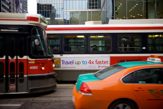
The King streetcar is currently broken. If you’ve ever taken it across downtown during rush hour, you know exactly what I mean. It’s infuriating. You might as well be crawling on your hands and knees. One of the goals of this initiative will be to get it working again. Good.
The shoulders of downtown – along King West and King East – are seeing some of the greatest intensification in the region. So much that it’s common for people in this city to complain that Toronto misplanned it all by allowing this development before the transit was there. Well, this is a quick and inexpensive way to get the transit there. Remember that when the inevitable “war on car” rhetoric ratchets up over the next year.
The project will be deployed, first, as a pilot project. That will allow the project team to test and iterate. It has also become the way you get things approved in cities. You first make them temporary.
But I am certain that we will quickly discover how necessary these changes were.
Today I learned about something new called 2030 Districts. They are: “designated urban areas committed to meeting the energy, water, and transportation emissions reduction targets of the 2030 Challenge for Planning.”
Toronto’s new 2030 District is downtown, which is bound by the lake in the south, Bathurst Street in the west, Dupont Street and Rosedale Valley in the north, and the Don Valley in the east.
It’s the first district outside of the US. The other established districts are in Seattle, Pittsburgh, Los Angeles, Denver, Stamford, San Francisco, and Dallas.
The goals for Toronto’s district are as follows (quoted from 2030 Districts):
To cut district-wide emissions in half, including zero-emissions from new buildings by 2030.
Support a better understanding of where and why energy use, water use, and GHG emissions occur across the District.
Work in partnership with building owners, service providers and conservation groups to accelerate the adoption of best practices for building design and management.
Facilitate broad stakeholder dialogues to uncover and overcome systemic barriers to long term reductions in energy use, water use and GHG emissions.
I’m looking forward to following and learning more about this initiative. I think many of us can agree that producing less, not more, GHG emissions in the future would be preferable. And we know that the bulk of it comes from both buildings and transportation.
UberX officially launched in Toronto today. Which means that Toronto’s taxi and limousine industry is about to get a lot more grouchy. For those of you who may not be familiar, uberX is Uber’s low-cost car service. Just like the regular version, you hail a car using your mobile phone. But this option will cost you 40% less than a regular taxi!
Here are sample rates from the Financial District to Yonge & Eglinton (midtown):
And from the Financial District to Pearson International Airport:
This is pretty exciting. Because as much as I think it’s great to use Hailo or Uber to hail and then pay for a car, the big problem in my mind has always been that cabs in Toronto are just far too expensive. The meter starts at $4.25 and shoots up faster than you can take a selfie in the backseat.
But obviously there’s an entrenched industry here that is not going to be happy about a startup eating into their fares. So I wouldn’t be surprised if we see a lot more backlash here in Toronto – as has been the case in many other cities. However I don’t think that’s a viable long term solution for the incumbents.
So instead of protesting and trying to ban it, we should be figuring out how to adjust to this changing reality. For the incumbents, this might mean lowering fares or figuring out a better way to differentiate themselves. A 40% discount is a pretty compelling value proposition. For me personally, I don’t know why I would ever pay more for a regular taxi, unless there was no other option.
On a side note, it’s worth pointing out that an uberX trip from downtown to Pearson is estimated to cost around $33 – roughly the same as what some people think the Union Pearson Express train will cost. That’s further evidence that charging a lot and targeting business travelers may not be the best strategy.
I’m a big believer in public transportation. I generally believe that the only way to build a big, efficient, and sustainable city is on the backbone of a good transit system. But at the same time, I’m open to fresh ideas. And I’m concerned with the inability of most cities to actually build transit in a way that meaningfully responds to demand.
So what are the alternatives?
The first thought that comes to mind is the delivery system itself. Some cities, such as Hong Kong, have successfully combined transit delivery with real estate development as a way to improve the economics behind building transit. And I think that makes a lot of sense.
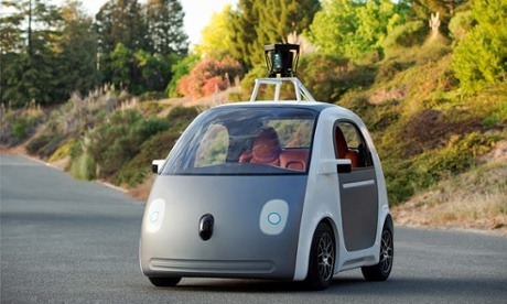
But my other thought is that maybe the solution to urban mobility is something completely new. Maybe Google is on to something with their driverless cars. Is that the future? Many would disagree.
We’ve established that cars don’t work all that well for getting people around in big congested cities. So what difference would it make whether or not the cars have a driver or not? Well, I was thinking about this last night and there are some meaningful differences.
A network of driverless cars would give us perfect information about all to the cars on the road. Similar to to how Google’s Waze navigation app feeds off user input (both active and passive), we’d know the exact number of cars on the road and the precise point in which additional cars would cause a drop in efficiency (i.e. a reduction in vehicle speeds).
At the same time, it could enable a powerful sharing economy. In a recent study done by MIT’s Senseable City Lab, it was found that roughly 80% of New York cab rides could be shared. That is, 80% of the time there’s somebody else who’s also traveling from roughly the same point A to the same point B.
So here’s what I’m thinking.
You use Google’s driverless car technology and the perfect information you get from the networked vehicles to create a fluid and ever-evolving transit network. What I’m imagining is that the driverless vehicles don’t operate based on a model of individual mobility; they instead operate on a principle of batched mobility.
Let’s say for example that there are critical mass of people who want to leave Liberty Village between 8:00am – 8:30am to travel to the Financial District. What they would do is enter this itinerary and then a “station” would get formed somewhere nearby. Users would get notified of the station’s location, which would be determined based on proximity to the highest concentration of “riders.”
The driverless cars would then get notified and would begin assembling the appropriate number of vehicles at the selected station location. As is the case with conventional forms of public transportation, most people would need to walk to the station. But never that far.
In essence, it would function as a cross between private and public transportation. You would get the economies of scale generated by public transit, with some of the individual conveniences of private transportation.
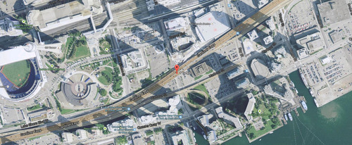
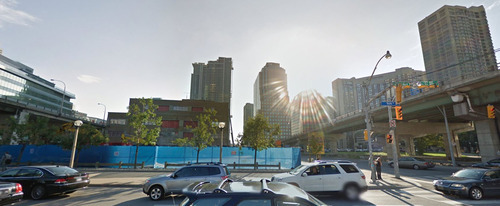
Yesterday news broke that Target is opening a two-storey, 145,000 square foot store at the base of a new mixed-use development in Toronto’s emerging South Core neighborhood. The site is at the north east corner of York Street and Harbour Street. And the larger development, called Harbour Plaza, will include a 35 storey office tower and 2 residential condominium towers at 65 and 69 storeys.
Here’s the location map:
And here’s the site looking east from York Street:
This is going to be huge for Target. The amount of current and proposed density within a short radius of the site is mind boggling. In addition to Harbour Plaza itself, look at what’s planned for 1 Yonge Street.
Plus with Union Station next door, I dare you to try and find a better connected mobility hub in the region. Now all of a sudden that retail radius gets even bigger. I can easily imagine suburbanites picking up a few things before they hop on a GO train (our regional rail system) and head home.
As of right now, they’re also the only game in town, as far as big box stores in the central core are concerned. But I wouldn’t be surprised if we see a competitor emerge alongside the 1 Yonge project. The site is big enough for one and Walmart isn’t going to want to get shut out of the area.
My only hope is that, from an urban design standpoint, the project is able to enliven and give back to Harbour Street. Right now it’s an arterial road with really no redeeming urban qualities. But with the York Street off-ramp being relocated and the park underneath it being expanded, now is the time to really transform the area.