Daily insights for city builders, delivered every morning at 6 AM ET. I’m Brandon Donnelly — a Toronto-based real estate developer and founder of Globizen. I’ve been writing here since 2013.

Tag: eglinton crosstown lrt

  • Three ways to optimize investments in transit

    Sometimes I’ll hear people in Toronto talk pejoratively about all of the development that’s been happening at Yonge & Eglinton (in midtown). They’ll say it’s too much density.

    But then you come across charts like the ones above (source previously shared here) and you realize that this location is the only section along the new Eglinton Crosstown LRT line that is actually starting to have enough people.

    Based on 2021 Census data, there were about 40k people within 800m of the future Eglinton and Mount Pleasant stations. In contrast, there are many downtown stations along the Ontario Line (also under construction) with around 80k people.

    Why this is important is because if the objective is to get people to ride this new transit and collect a lot of fares, then the single most important factor is going to be the amount of people that live, work, and play adjacent to each station.

    Now, I’m not a transportation planner, but in my mind there are three simple ways to think and go about optimizing for this:

    1. You can look at where population densities are already high and then add new transit to service these densities. This is what is happening with the Ontario Line and it was long overdue. We know that ridership is going to be relatively high because of the chart at the top of this post.
    2. You can look at where there’s existing transit and then work to optimize the land uses around it. This is what we should be doing a better job of along the Bloor-Danforth line, where certain station areas have actually lost people over the last few decades. This is the opposite of what you want next to transit investments.
    3. Lastly, you can also proactively plan new transit while simultaneously encouraging more density. An example of this would be the Vaughan Metropolitan Centre (just north of Toronto). Extend the line and encourage growth. This is good. The only thing with this approach is that it can seem a bit misaligned if you’re currently failing at #1 and #2.

  • Rail + property — let’s try it again, okay?

    The Eglinton Crosstown line is going to open, here in Toronto, sometime next year — I think. And I’m sure that it is going to be a massively beneficial addition to Toronto’s transit network. But at the same time, we should be talking about this:

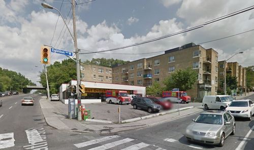
    Urban transit stations shouldn’t look like this. It’s a missed opportunity, both in terms of the foregone housing (and other uses) that could be on top of these stations and the additional value that could have been captured from these air rights. Transit is a crucial lever for land values and development overall, and so it’s no wonder that many of the best transit authorities around the world think in terms of “rail + property”.

    So what happened here?

    I don’t know exactly. But I do know that nearly a decade ago I called up Metrolinx and said, “Hey, so I’m a developer who can build things. I see that you’re building a number of exciting transit stations along Eglinton. Want me to build on top of them for you?” Now obviously Metrolinx wasn’t going to be able to sole-source to Brandon, but regardless, I thought it should happen and I just hoped to be in the mix.

    In 2015, things did start to happen. Avison Young, on behalf of Metrolinx, issued a request for proposal to developers for 4 sites/stations along the line. There were two at Keele Street, one at Weston Road, and one at Bathurst Street. And at the time, it was thought that these sites could generate somewhere between $14-22 million (speaking of reasonable).

    I think it was also being viewed as a bit of a pilot. If things went well with these 4 initial sites, then this same approach was going to be rolled out across all suitable sites on the line. I’m not sure what happened with the RFP or the broader intent — maybe some of you know — but it clearly didn’t pan out as planned.

    That’s too bad. But I suppose done is better than perfect. Plus, now we’re building the Ontario Line and so we have another opportunity to get it right. And right means lots of density on top of stations — both directly on top and all around it.

  • Metrolinx takes first step towards rail + property in Toronto

    image

    I’ve written quite a bit about the advantages of a “rail + property” model when it comes to building public transit. It’s a model that works quite successfully in other parts of the world, such as in Hong Kong.

    However, in North America the notion of land value recapture or of transit authorities acting as real estate developers is still very much in its infancy. We’re myopically focused on rail. 

    Which is why I said about 3 months ago that if the stations along the new Eglinton Crosstown LRT line in midtown Toronto became single storey and single purpose buildings, that we will have missed an enormous city building opportunity.

    Since that post I had a number of conversations with the folks over at Metrolinx and I was delighted to learn that there were in fact plans to build additional density on top of the stations. And as of today they’ve gone completely public with that intention.

    Metrolinx, with the help of Avison Young, has just issued a request for proposal (RFP) for 4 sites along Eglinton Avenue in the city. Two of them are at Keele Street, one of them is at Weston Road, and the last one is at Bathurst Street. The 4 sites could generate between $14M – $22M.

    The objective is to find suitable developer partners to help them build on top of their planned LRT stations. And it’s a step in exactly the right direction for Metrolinx and this city.

    Image Source: Google Streetview

  • Understanding the radius of demand for transit

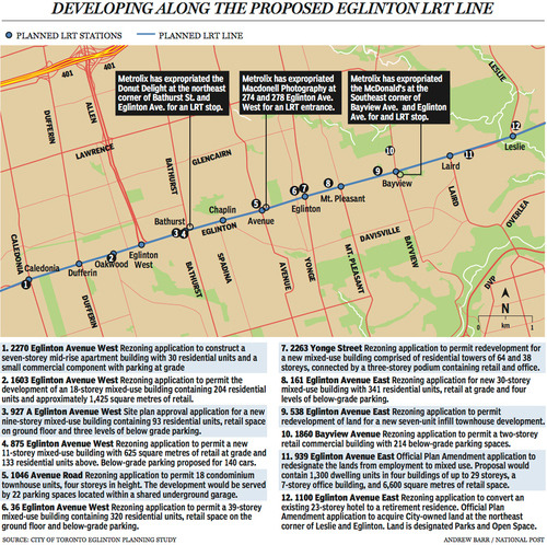
    Last week The National Post published an article talking about Toronto’s Crosstown LRT and how it’s spurring a wave of development all along Eglinton Avenue. Below is a map, taken from that article, showcasing some of the developments that are currently in the pipeline and awaiting the Crosstown’s opening date of 2020.

    image

    Not surprisingly, developers like transit investment. But more specifically, they like fixed track transit investment. Rarely do new bus routes elicit the same sort of response that you’re seeing above. And that’s because fixed track investment has permanence. If you’re going to go long on an area, you want certainty.

    As the Crosstown tunnel boring machines move across midtown Toronto, I thought it would be interesting to look at a transit concept that I first learned about through Jarrett Walker’s Human Transit blog. It’s called: the radius of demand

    One of things that transportation planners look at when designing and building a new line is the spacing of stops. Typically, as you move from buses all the way up to subways, the spacing between stops and stations increases. Spacing is always a bit of a trade off though, because more stops means easier access for riders, but it also means slower overall service. Somewhat famously, Paris designed its metro system so that you’re rarely more than 500 meters away from a station. 

    Once you have your station locations, it’s quite common to then draw a radius around each stop to simulate the catchment area. In other words: How much of the city can I service with this station and how far will people be willing to walk in order to get there? However, this distance, which is the radius of the circle, usually depends on the type of transit. Oftentimes people are willing to walk further in order to get to faster transit service.

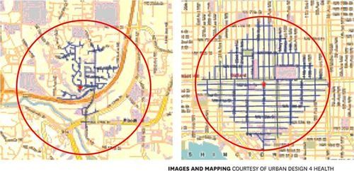
    But what’s most interesting about this radius of demand is that it’s entirely dependent on the fabric of the city. Take for example, the following two maps from Seattle, which I have taken from Walker’s blog. On the left is a suburban setting and on the right is a downtown setting. In both cases, the red circle represents a 1 km radius.

    image

    Now, if humans could fly over barriers, such as highways, and every Seattle resident was willing to fly exactly 1 km to a transit station, these two radiuses of demand would be perfectly accurate. But since that’s not the case, we instead need to look at what actually represents a 1 km walk – those are the blue lines in each image.

    Because once you do that, you realize that the cul-de-sacs and highways on the left make it impossible for most of that radius of demand to actually walk to the station in under 1 km. So the catchment area actually becomes much smaller. On the other hand, if you look at the image on the right, you’ll see that the tried and true city grid is actually remarkably efficient for walking. Almost all of the circle is serviced.

    So as the Eglinton Crosstown LRT makes its way through the center of Toronto, I think it’s important to keep in mind that it’ll be cutting through quite a few different kinds of street grids. Some of them will be highly conducive to transit usage and others not as much. And in many ways, this is one of the greatest challenges of transit investment. The track itself is only one part of the puzzle.

    That’s why the City of Toronto is also undertaking a planning exercise called Eglinton Connects. Its intent is to leverage the opportunities, as well as address the challenges, that will result from Metrolinx’s Crosstown LRT. If you’re interested in the future of Eglinton Avenue, you should consider getting involved. Oftentimes it’s only the critics that speak up. But that’s not the best way to build anything.