Daily insights for city builders, delivered every morning at 6 AM ET. I’m Brandon Donnelly — a Toronto-based real estate developer and founder of Globizen. I’ve been writing here since 2013.
“Complete streets” are streets that are designed to be safe for all users: people who walk, bicycle, take transit or drive, and people of varying ages and levels of ability. They also consider other uses like sidewalk cafés, street furniture, street trees, utilities, and stormwater management.
Right now, the city is in the public consultation phase. If you’d like to provide your feedback, you can do that here. You have until October 30th. The online tool is also pretty neat. You can drop comments on specific areas of the street. And already the map has been totally filled up.
This is an important and busy artery in midtown. I use it all the time as a pedestrian, cyclist, and driver. It’s not the best street, though. Yesterday it took me 45 minutes to drive from one end of it to the other. Along with better street design, this part of the city could use better transit.
I’m looking forward to seeing how Dupont ultimately gets designed.
I am not a transportation engineer, but sometimes I like to, you know, pretend. And lately, I’ve been thinking about how to better design the Toronto intersection of Dundas, Dupont, Annette, and Old Weston (which I touched on briefly over here). It’s a weird 5-point intersection that is often cited as one of the most confusing in the city. And so there’s a lot that could be done.
Here’s what it looks like today:
The centerpiece is the Dundas-Dupont Traffic Island, which is actually a city-owned park. It’s not the most generous green space, but the real problem with this park is that it’s very much an island. There’s really only one pedestrian access point — its north end. For the most part, you need to be unlawful in your movements on and off it.
This is a fairly common occurrence in cities. The island is, almost certainly, a remnant space. It was never explicitly designed; it is just what was left over after they figured out how to connect all of these streets and negotiate the intersection’s grade changes.
The other signal, that these are remnant spaces, is the paint markings on the street. Their main job is to tell cars where to go. But they’re also unproductive spaces. Nobody is intended to actually occupy them. So what they really say is, “we have too much road and we didn’t know what to do; so we just painted them.”
If you watch the below video of Claire Weisz (founder of WXY Studio) explaining the work that she has done in New York City, you’ll see remarkable similarities to what I’m talking about here. This sort of thing happens all the time, especially at messy intersections where multiple streets converge. The objective was to connect the streets and the rest became a byproduct.
But when properly designed, these spaces actually become better for everyone: drivers, cyclists, and pedestrians. And this Toronto intersection strikes me as a perfect candidate. So if my local Councillor Gord Perks is reading this post, I would ask him to do what he can within the city to encourage this kind of positive change.
And not just here, but wherever there is a street that sucks.
Let’s resume looking at sidewalks and public spaces.
If you look in the City of Toronto’s Official Plan for the stretch of Dundas Street West that runs between Dupont Street and Bloor Street West, you’ll find a map that looks like this:
Red signifies “Mixed Use.” And so if you were to just look at this map, you might naturally assume that, in the real world, this is a continuous main street that connects The Junction neighborhood down to Bloor. But that’s not actually the case. Instead, it looks like this:
Because of the rail corridor on the east side, it is a single-sided street. And generally speaking, these don’t make for the best retail streets. But it also has narrow sidewalks and a compromised public realm. If you go back to the map I shared yesterday, you get this:
I don’t think 30cm is entirely accurate here, but that’s beside the point. What matters is that this is just one of many examples in the city of a discontinuous public realm. (Here’s another, undignified example, from Parkside Drive.)
Over the years, there have been a number of design concepts proposed. Below is one by Brown + Storey Architects that was done I don’t know how many years ago. Their proposal widened the sidewalks along this stretch, and added bike lanes. They also proposed a roundabout at the intersection of Dundas, Dupont, and Annette, which is another matter that needs addressing.
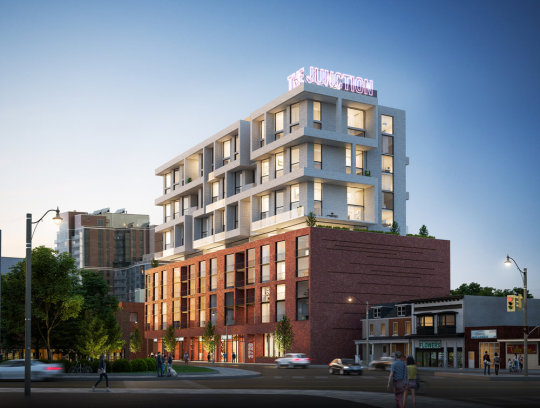
But none of this has been implemented and I don’t know of any plans to do it. When we were going through the rezoning process for Junction House, we were made aware of some transportation studies that had been done for the above intersection. But that’s about it. There wasn’t an actual ETA.
However, now that my commute consists of walking up and down this part of Dundas, I’ve been thinking more about how it could be improved.
I think there’s no question that the sidewalks need to be widened. It would also be helpful if there were crosswalks to facilitate getting off the south end of this exotic island:
But equally important, I think that something should be done about the single-sided nature of the street. Given that there’s limited width, my mind immediately goes to shipping containers, or something similar, to start activating the east side of the street.
This has already been done further south on Dundas (east of Bathurst):
And it could work here too. Already there’s a Blondie’s Pizza anchoring the south end of this stretch (really fantastic pizza, by the way):
But I would love to hear your ideas, as I’m currently in the market. I also don’t think that you necessarily need to be from Toronto in order to comment. Great streets are great streets. So if it were up to you, what would you change, if anything, about this part of Dundas Street West? Let me know in the comment section below.
This morning I spoke to the Globe and Mail about the evolving nature of Dupont Street here in Toronto. The impetus for the discussion was this: Dupont Street is now seeing a lot of residential intensification, but the street itself remains a bit of a crosstown highway. It’s not yet a “complete street.” And since Junction House is effectively on the west end of this midtown artery, John Lorinc asked to get my thoughts.
The point I tried to make is that, in my opinion, this is first and foremost a zoning issue. Dupont Street is seeing intensification, but it is largely happening on the north side of the street, abutting the rail corridor (purple and red in the above Official Plan map). The south side of the street is, for the most part, a low-rise neighborhood (yellow in the above map).
This kind of edge condition is somewhat unique in the city: low-rise on one side of the street; higher density housing, retail, and office on the other. But it is particularly problematic if you’re trying to create a great main street, because single-sided retail streets generally don’t work very well.
We could certainly have a discussion about sidewalk widths, bike lanes, and other streetscape improvements; but in my mind, there is nothing inherently bad about the cross section of this street. The right-of-way width is 20 meters, meaning there are generally two lanes going in each direction. This is a dimension you’ll find all over the city, including on beloved streets like Queen Street.
The problem here is what is abutting the street, and it is something that is systemic across the city: we have too many arterial roads that only allow for low-rise housing. So if you were to ask me what to do next, and I was asked this morning, the first thing I would do is up-zone the south side of Dupont and allow for non-residential uses at grade.
And once this is done, I am certain it will snowball many other positive improvements.
Just northwest of the intersection of Lansdowne Avenue and Dupont Street here in Toronto, there is something known as the Davenport Diamond. It refers to the intersection of two rail lines. Going north-south is the Barrie GO corridor (regional rail service). And going east-west is a set of Canadian Pacific Railway tracks. The problem with this Diamond is that it is one of the busiest train intersections in North America and these two corridors meet at grade. So it is a problem for service levels on this corridor.
To address this bottleneck, Metrolinx has been working on a project called the Davenport Diamond Guideway and Greenway. First and foremost, what it will do is elevate the Barrie GO corridor between Bloor Street in the south and Davenport Road in the north, allowing trains to pass over the CP tracks (rail over rail), as well as over streets like Wallace Avenue (rail over road). Metrolinx expects to have this guideway complete by spring 2023 and it will be a good thing for rail service levels across this region. Construction activity is already happening.
But the other thing this guideway does is open up the ground (literally) for a new greenway. Metrolinx is calling this the public realm component of the project, and it expects to procure this work separately, as well as complete it only after the guideway is operational. The ETA for this is 2024. However, a design was completed for the greenway back in 2018. It was completed by gh3 — one of my favorite architecture firms in the city. And it is my understanding that this original design will be the foundation for the public realm design. Or at least, I hope it will.
Back in 2011, blogTO ran an article calling Geary Avenue one of the ugliest streets in Toronto. And it’s certainly up there. It’s an industrial street with a mixture of different building types (lots of autoshops), giant power lines running along the south side of it, and a railway disconnecting it from the city to the south.
But as somebody who used to live around the corner from this street, I’ve had my eye on it for a number of years. Despite the fact that it was never very pretty, it always felt like an area with lots of potential. And sometimes it’s the areas that seem most unlikely to gentrify, that end up doing exactly that.
So whether you call it Dovercourt Park, Dovercourt Village, or some other name, I think it’s only a matter of time before Ossington cool moves north and the area in and around Dovercourt Road and Dupont Street becomes one of the hippest areas in the city. Get ready.
Full disclosure: I own a house very close to this neighborhood.