
Apparently I’ve been living in the dark ages. The One Delisle project team just introduced me to Bluebeam Revu and, frankly, I’m not sure how we were marking up PDF drawings before this. It’s faster and more responsive than Adobe Acrobat. Everyone’s comments sit nicely in the cloud. And you can even take measurements off of the drawings. It kind of feels like a light and friendlier version of AutoCAD (which I haven’t used in over a decade). Marking up drawings is something that I do regularly as part my job. Sometimes I do that with trace paper (I did that for probably every suite at Junction House). But more often it has been with Adobe Acrobat. If you’re in the same boat and aren’t yet using Bluebeam, I would encourage you to check it out.
Tag: drawings
-
Low but dense — a missing middle solution for Toronto’s neighborhoods
Alex Bozikovic (architecture critic for the Globe and Mail) is one of the most vocal proponents of more housing and more density within Toronto’s low-rise neighborhoods. Last year, he organized an international design competition where he asked firms to come up with innovative, yet sensible, solutions for how this could be done. I’m a little late getting to this, but today I’d like to walk you through this immensely clever solution by Batay-Csorba Architects, called Triplex Duplex.

The project uses two prototypical, but random, semi-detached lots from the Christie & Bloor area of the city. Each one is 18′ wide x 100′ deep. So your typical long and narrow lots. From the street (see above image), it looks highly contextual. But in plan, you begin to see the 3 main volumes of the project emerge. Here’s a ground floor plan from the architect:

Each volume is around 2,500 square feet. I presume that includes the basement. If you exclude the basement area and the vertical voids throughout the project, which you’re allowed to do in your calculation of gross floor area in residential zones, I suspect we’d arrive at an FSI (density) number that isn’t that much more than what already exist in these sorts of areas.
At the front of the house (right side of the above plan) is a set of stairs (and a patio) leading down to the front basement unit and a set of stairs leading up to the main front unit. An inset patio also forms part of this main entrance (image below), which is a great way of adding outdoor space while at the same time maintaining privacy across the units. These strategy is one of my favorite aspects of the project.

The rear units are similarly accessed at the back of the building. And the two middle units are accessed along the side of the house. All in all, this housing typology has the ability to accommodate up to 6 units: 3 main suites and 3 secondary type suites. By the architect’s own estimate, this could result in 147,000 new housing units across the city if every lot occupied by a semi-detached house were to be redeveloped in this way.

But I wonder if any consideration was given to the secondary (basement) suites that may already exist in these zones. Because in some cases, and as beautiful as these homes may be, we may only be talking about 2 additional suites. Triplexes are also already allowed in some areas of the city. So does this ultimately achieve its intended goal, which is the creation of more “missing middle” housing in order to ease overall housing pressures? Or do we need to be thinking bigger?
As a follow-up to this post (subscribe to stay connected), I am going to look at what a development pro forma might look like for a project of this scale. The numbers have a way of answering a lot of questions. That said, kudos to Alex for taking on this initiative and kudos to the design team for a pretty spectacular architectural solution.
All renderings by the talented Norm Li.
-
What’s in a roof?

Over the weekend I stumbled upon this illustrated Medium post by Alfred Twu comparing sloped and flat roofs. The argument is that these two roof types are coded. In this part of the world, at least, sloped roofs signal low-rise “house” and flat roofs signal big city “high-rise.”
I’m not yet convinced of this association with height, or of all the claims made in the article. Did New York City really make the flat roof commonplace in our cities? But the idea that a roofline can trigger certain associations — or even become divisive — is a fascinating one.
Take, for example, Am Fischtal in Berlin. On one side of the street you have, still to this day, homes with flat roofs. And on the other side you have homes with sloped roofs. This clean divide is the result of a supposed “roof war” that took place during the Weimar Republic.
At this moment in time in the suburbs of Berlin, the kind of roof you chose to live under was a proclamation of your political orientation. I’m not sure roofs have as much gravitas as they did in the 1920’s on Am Fischtal, but they still do say something.
Image: Alfred Twu
-
An example of low-rise intensification: Union Street EcoHeritage
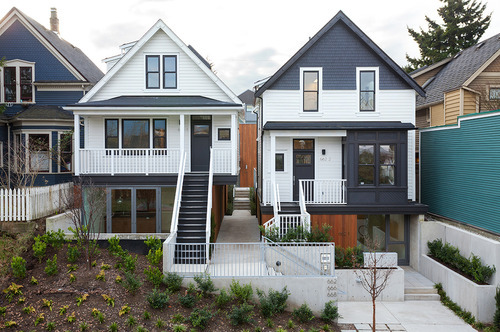
In yesterday’s post about the 3 stages of intensification, I mentioned a project in Vancouver called Union Street EcoHeritage by SHAPE Architecture. I used it as an example for sensitive low-rise intensification.
Since it’s a very cool project (and most of you probably didn’t click through), I thought I would dedicate today’s post to explaining the project.
The picture at the top of this post is what it looks like today (the front elevation). If you were to pass by it, I suspect most of you would just think it was a pair of renovated single family homes. But there’s much more to it. What started out as only 2 dwellings, ended up as a site for 7 dwellings.
Here’s the before shot:
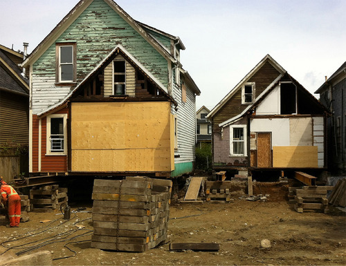
The homes were moved and actually raised up in order to accommodate additional density. Here’s a section that better explains what was done (black is existing; green is new):

The 2 existing homes were raised up so that an additional dwelling unit could be placed beneath each one. At the same time, additional units were added in the rear, both attached to the existing homes and at the back of the site facing the laneway. And so this project is actually one part laneway house.
Here’s a photo of what that rear interior space looks like (it’s stunning):
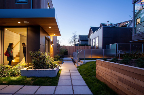
Not surprisingly, this project won a bunch of awards and has been widely celebrated as an affordable housing solution. It’s exciting to see Vancouver take the lead on low-rise intensification. It’s one of the reasons that I think it’s only a matter of time before Toronto starts to look towards similar solutions.
Images: SHAPE Architecture Inc.
-
How to apply for information
This morning I was at Toronto City Hall looking for old drawings of a building that I’m now working on. While I was there, I also ran into John Tory, and so I was given the opportunity to congratulate him in person on his recent mayoral win. But that’s irrelevant to this discussion.
What I instead want to talk about is access to information.
We are living in a world that produces an unprecedented amount of data and information. Back in 2010, Eric Schmidt – the former CEO of Google – quite famously stated that we were creating as much information in the span of 2 days as we did from the dawn of civilization up until 2003. And that was 4 years ago. So I can only imagine what the numbers look like today. The internet is basically a giant data generating machine.
But a lot of that information isn’t all that useful and much of the really useful information that’s out there isn’t yet digitally accessible in the ways that we have now become accustomed to. For example, for me to access old drawings and documents for a building in Toronto, I had to do the following…
First, I had to file what’s called an Application for Routine Disclosure. It was a 2-page form that I was able to submit to the city over email. The fee for this application was $66.60. Once the city confirmed receipt of this application, they then went looking in their archives for any drawings and documents that might exist.
After about a week, I called them up and they informed me that drawings had been found and I could now setup an appointment between the hours of 8:30am and 11:30am, Monday to Friday. I went in the next day and the lady – who was very helpful I must say – presented me with a stack of microfiche sheets (I think that’s what they’re called).
I then took these sheets and walked over to a machine (shown below) where I could inspect the drawings. Everything about the machine had to be reversed. In order to get the drawings to show up properly, I had to put the microfiche sheets in upside down and mirrored left-to-right.
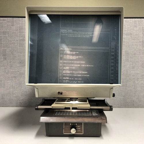
As I looked through the sheets, I was then instructed to demarcate – with a post-it note – which drawings I wanted a copy of. At the end of it all, the lady filled out another form that would be sent to a printing shop who would then convert these microfiche drawings into PDF files for me. I think that will end up costing a few hundred dollars when it’s all said and done.
However, at this point, I also learned that this procedure applied only to drawings, and not to any of the other documents that I was able to find on the microfiche sheets. For non-drawing documents, I actually had to file what’s called a Freedom of Information application at a separate counter upstairs. So I did that. I applied to free the information. It was only $5, but the turnaround time for that is 30 days.
Now, I realize that we’re talking about old drawings and documents. Some of them were from the 1940s. But I’m a big believer in the value of open information. And so today was a good reminder to me that, even though we now have a tremendous amount of useful information at our fingertips, there’s still lots of valuable information that’s really difficult to get.