
Daily insights for city builders, delivered every morning at 6 AM ET. I’m Brandon Donnelly — a Toronto-based real estate developer and founder of Globizen. I’ve been writing here since 2013.

Tag: downtown relief line

  • Where should Toronto’s relief subway line go?

    Those of you from Toronto might be aware that the city is currently assessing the possibility of a “relief subway line” that would connect the downtown core back up to the Bloor-Danforth subway line in the form of a stretched out “U”.

    The reason this line is being called a “relief line” is that – in addition to providing local service all across downtown and its “shoulders” – it would also relieve much of the pressure that the Yonge-Bloor interchange is facing today. Instead of always having to connect at that location, passengers coming from the east and west would be able to do so sooner as a result of this new subway line (bypassing Yonge-Bloor).

    For those of you who are regular readers of ATC, you might know that I’m a big supporter of this relief line. I believe it should be our number one transit priority. It’s going to cut through areas of the city that have some of the highest population and employment densities, and so it’s an area where I think subway makes sense. The ridership would be there.

    Many people at the city also seem to agree:

    https://twitter.com/jen_keesmaat/status/571745025941487616

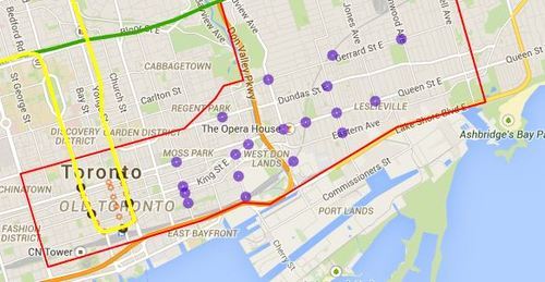
    Given that an assessment is currently underway, the city is looking for feedback from the public. One of the ways you can do that is by clicking here. The site will allow you to comment on the potential station locations (shown below using purple circles). I did it this morning and I would encourage you to do the same if you’re from Toronto.

    For clarity, this current study is only for the eastern portion of the relief line (study area is outlined in red below).
    image

    Once you’ve given this some thought, I’d love to have a discussion in the comments about where you think the relief subway line should go (or if you even think it’s a good idea in the first place).

    My initial thought is that it should connect into King station, run along King Street East, merge with Queen Street East near the Don Valley, go through Riverside and Leslieville, and then start making its way north to Danforth Avenue.

    My reasons are as follows:

    • King Street East is the most vibrant pedestrian street on the east side of downtown. There isn’t enough commercial activity further south.
    • King Street would allow it to eventually cut right through the Financial District when it heads westward.
    • The connection to Union station (for GO Transit, VIA Rail, and the Union-Pearson Express Train) would be manageable from King Street. Plus, SmartTrack may feed directly into Union.
    • King Street is roughly the midpoint between Queen Street and Lakeshore Boulevard. And if you place it too far south, it would take away from the proposed Queen’s Quay LRT line.
    • Having it merge into Queen Street near the Don Valley would allow it to service both Regent Park to the north, as well as the West Don Lands neighborhood to the south. It would also allow for a connection to a Cherry Street LRT line servicing the future Portlands neighborhood.
    • Queen & Broadview is emerging as a major node with a significant amount of density in the pipeline. And further north, Dundas & Carlaw is similarly seeing a lot of intensification.

    But I may have missed a few things. These are just my thoughts. What are yours?
  • The ultimate Toronto transit map

    image

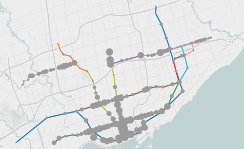
    If you live in Toronto and only give serious thought to one thing today, it should be to this interactive transit map created by Metro.

    The map shows all existing, planned, and proposed transit lines in the city, and then overlays population densities, commuting patterns, household income, and so on. It’s a super valuable map that I think reveals a lot about how we should be focusing our energies to get Toronto moving.

    So what sorts of things does it tell us? I’ll give 2 examples.

    If you look at commuting patterns across the Bloor-Danforth subway line, you’ll see that Runnymede station in the west is where people switch over from taking transit to driving. People west of that station tend to drive. Naturally, it also happens to coincide with where population densities start to fall off.

    By contrast, if you look at the east side of the city along the Danforth and beyond, the entire stretch more or less relies on transit to get around. Part of this likely has to do with income levels, but it’s also because of the availability of the Gardiner Expressway. There’s no equivalent in the east end. Dylan Reid of Spacing Magazine believes this makes a case for some sort of road pricing along the Gardiner, and I would agree.

    As a second example, look at the population densities along the proposed Downtown Relief Line, Finch LRT, and John Tory’s SmartTrack line. Outside of the core, the population densities are relatively low along the proposed SmartTrack line – which is never a good thing for rapid transit.

    There’s also no Sherbourne station on the SmartTrack line, which happens to have the highest population density across the entire Relief Line – 22,131 people per square kilometre! That’s more than any other stop along the Yonge-University subway line except for Wellesley station.

    I’ve written about this a lot before, but I think we need to do a better job of matching up transit investment with expected customer demand. Too often we let politics get in the way of rationale decision making. Maybe it’s time we did something like set minimum population densities. If you want a subway line in your area, you have to first bring the people.

    What else does this map tell you?

  • It’s voting day in Toronto

    Today is municipal election day in Toronto.

    About 8 months ago I publicly announced here on ATC who I would be supporting, and my position hasn’t changed. I was disappointed by the fact that he ended up backing away from his initial promise of a true downtown relief subway line (see blog post), but I nonetheless continue to support his candidacy.

    In the words of Mike “Pinball” Clemons, he’s “the right man at the right time.” Click here if you can’t see the video below.

    [youtube https://www.youtube.com/watch?v=ouqv782giyw]

    But I’m not here to try and sway your vote. That is ultimately your decision. However, I am here to encourage you to get out and vote. Regardless of who you might be supporting, I think it’s important that you get out and take a position. So I hope you do that today.

    Happy Monday!

  • John Tory is running for mayor of Toronto

    Yesterday I was at brunch for a good friend’s birthday and a few of us started talking about politics and the future of Toronto. We immediately became depressed by the fact that Rob Ford, could actually, get in again. For those of you outside of Toronto, I know this sounds like pure lunacy.

    We then speculated as to whether John Tory would ultimately run again. Though it would split the conservative vote (between Ford and Karen Stinz), I was hoping he would. Then, just like magic, Tory announced his candidacy. Here’s the video:


    While some would call it an oxymoron, John Tory is often painted as a “Red Tory”. He’s fiscally conservative, but then holds socially liberal views on issues such as same-sex marriages.

    But perhaps more importantly for the Architect This City audience, Tory is also a city builder. He’s Chair of the Greater Toronto CivicAction Alliance, which is non-profit group focused on transportation and economic development in the region. And this comes through in his clear support of the Yonge relief subway line (see above video).

    So even though this risks splitting the conservative vote, I will be supporting John Tory’s candidacy during this year’s mayoral election in Toronto.

  • Toronto’s schism is hurting the city

    Instead of talking about the latest Rob Ford scandal (honestly, how is he still mayor?), I’d like to focus on his abilities as a transportation strategist.

    Here’s an excerpt from a Toronto Star article published this morning that talks about the urban vs. suburban divide in this city and our inability to depoliticize transit planning. It’s called, “Suburban envy only makes things worse: James.”

    image

    In another committee room, councillors were debating the proposed downtown relief subway line — only, they were afraid to name it such. Downtown is a section of the city that dares not voice its name, for fear that aggrieved suburbanites will rise up and object.

    This is not hyperbole. Not long ago, the mayor indicated he is not interested in the relief line until there are subways on Sheppard East and on Finch West. Why? Because downtown “has enough subways.”

    Downtown has enough subways? Do you think Ford looked at population density, number of stops, ridership levels, and so on, in order to come up with this position? Or did he just look at where his voter base resides?

    We need to get past this downtown vs. suburban schism. We’re all in this together. In fact, the whole Golden Horseshoe region is in this together. And until we start acting as a unified entity, we’re not going to reach our full potential. 

  • Wrong subway

    It was announced this morning that the feds will be contributing $660M towards Toronto’s new Scarborough subway line. While transit investment of any kind is generally a good thing, it’s a shame that we can’t get our priorities straight. Decisions are being made based on politics rather than rational thought.

    Here’s what TTC CEO Andy Byford said:

    “We all know that Toronto has a congestion problem, so it can only be good that we get more funding,” Andy Byford told reporters after the announcement. “I’ve said since the day I got here that the downtown relief line remains a priority for the TTC. I reiterate that point. But I think that, with the time scales available, it’s possible we can do more than one thing at a time.”

    This is Byford being diplomatic.

    The downtown relief line is absolutely the most important (planned) subway line in Toronto. For one, the Yonge & Bloor subway interchange is at capacity. Until these pressures are relieved, any extension of existing lines will only exacerbate the problem.

    At the same time, the density levels are way higher in the core, meaning that ridership levels will be higher and the required government subsidies will be lower. Not surprisingly, subway lines make more fiscal sense when you build them where demand is greatest.

    So the irony is that our Mayor – who ran on a campaign to “stop the gravy train” – is pushing to build a rail line that will ultimately cost taxpayers more money.

    Oh, politics.