Daily insights for city builders, delivered every morning at 6 AM ET. I’m Brandon Donnelly — a Toronto-based real estate developer and founder of Globizen. I’ve been writing here since 2013.

Tag: development

  • Prerequisites for a successful pedestrian-only street

    image

    A few of us had a really great discussion on Twitter recently about pedestrian-only streets. It was kicked-off by a tweet about Spark Street Mall in Ottawa, which many argue needs a rethink.

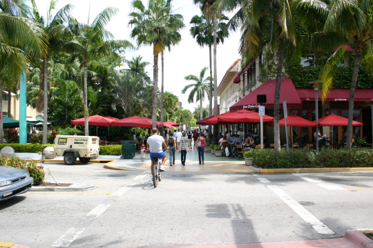
    One of the comments was that a lot of people tend to overvalue their worth. And I will admit that I am probably one of those people. If you’ve ever visited places like Grafton Street in Dublin, Lincoln Road in Miami Beach, or Kensington Market in Toronto on a pedestrian Sunday, you can’t help but think to yourself: why don’t we do more of this? They’re such great places to be.

    But the research suggests that these success stories are few and far between. 

    Below are the key findings from a report that was shared on Twitter during our discussion. It’s by Cole E. Judge and it’s called, The Experiment of American Pedestrian Malls: Trends Analysis, Necessary Indicators for Success and Recommendations for Fresno’s Fulton Mall.

    – Pedestrian malls in the United States have an 89% rate of failure. Most have been removed or repurposed. Only 11% have been successful.

    – Of the 11% successful pedestrian malls, 80% are in areas with populations under 100,000.

    – Certain indicators need to be present for a pedestrian mall to be successful in the United States: near or attached to a major anchor such as a university, situated in close proximity to a beach, designed to be a short length in terms of blocks, in a town/city with a population under 100,000, and/or located in a major tourist location such as Las Vegas or New Orleans.

    – Cities that have embraced the Main Street and Complete Streets models have experienced turn-arounds in their downtowns with more investment, higher occupancy rates and more pedestrian traffic.

    Though the report lists proximity to a beach as helping pedestrian malls, this is more about having a strong anchor than it is about climate – which is a commonly held excuse for why they don’t work. The report cites lots of failed pedestrian malls in California.

    Furthermore, if you look at the list of successful pedestrian malls, about half of them are in colder climates. And if you search the report for the word “weather” it only comes up once. The word “climate” doesn’t come up at all. 

    So I don’t believe that they’re not possible in colder climates. Ski resorts, for example, usually have great pedestrian-only spaces because they have a strong anchor – the mountain.

    But I do agree that pedestrian-only streets aren’t possible everywhere. And the more I think about this topic, the more I agree that we are overvaluing pedestrian-only. I guess that’s why our focus today is more on complete streets.
  • Why Toronto needs a night mayor

    Recently I wrote about the first Night Mayor Summit being held in Amsterdam. As part of this, I spoke about Amsterdam’s first night mayor – Mirik Milan.

    Since then (but obviously not because of my post), the idea has seemingly taken off. Below are a couple of excerpts from a recent Guardian article.

    This pragmatic and classically Dutch notion is now being copied across Europe: Toulouse, Zurich, Paris as well as several other Dutch cities have night mayors too.

    This week the mayor of London, Boris Johnson, announced plans for a “Night-Time Commission”, a six-month assessment of how to protect and manage the city’s £66bn night-time economy which is likely to recommend the creation of a “night-time champion” role. 

    Berlin is considering it too, and in April, Amsterdam will host the first global Night Mayors’ Summit.

    Why is this happening? Simple:

    “Late-night people are typically young, educated, creative, entrepreneurial – people you want in your city, and who work in the creative industries and startups you also want. If places like Berlin have flourished, it’s not just because of low rents. It’s because they’re nightlife capitals.”

    So if you’re reading this, Mayor John Tory, now is probably your last chance to make Toronto a North American leader in this regard. 

    It’s great that we are trying to push the Toronto – Waterloo region as a global startup hub, but so is every other major city and region in the world. A focus on startups is so commonplace in today’s economic development strategies, that at this point it almost feels meaningless. What are we going to do to stand out in this competition for the world’s best talent?

    If everyone believes something to be true – such as, there’s value in having a robust startup ecosystem – then it’s no longer innovative. It’s just the way things are. To take it to the next level, we’re going to have to do things that will probably feel uncomfortable at first – particularly for old establishment Toronto.

    I’m not saying that having a night mayor is going to be the silver bullet for our startup ecosystem. There’s no such thing. But I am saying that it should be one component of our larger strategy. 

    Because already there’s a growing number of European cities who have come to this one simple realization: people are drawn to kickass places.

    If you agree with this post, I would encourage you to leave a comment below and also tweet the Mayor of Toronto.

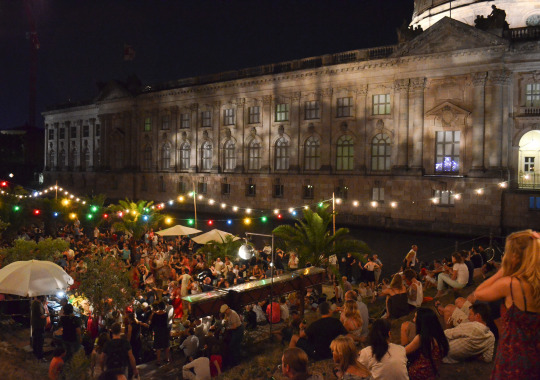
    Image: Berlin nightlife by Tom Stromer

  • Enhancement Zones: The mid-rise performance standard that didn’t make the cut

    I’ve written a lot about mid-rise development on this blog and elsewhere. 

    I recently wrote this post responding to a tweet by the Chief Planner of Toronto. And towards the end of last year, I wrote a longer piece for developer Urban Capital’s annual magazine. If you missed it, you should definitely download a copy. Not so much for my article, but because, overall, the UC magazines are excellent. (Credit to David Wex.)

    Today, I’d like to focus on one specific “performance standard” from Toronto’s mid-rise guidelines that I’ve been thinking about lately. But more specifically, I’d like to focus on a performance standard that was initially contemplated but never actually got adopted. 

    (I apologize in advance if this post gets a bit too geeky for some of you. It refers to a specific land use policy in Toronto, but it has much broader relevance.)

    If you take a look at the final Avenue & Mid-Rise Buildings Study and turn to page 56, you’ll see that Performance Standard #5B (Rear Transition to Neighbourhoods: Shallow Properties) was stricken from the report. It was never adopted as a standard.

    So what is this all about?

    This performance standard had to do with something called “Enhancement Zones”, which was proposed as a way to deal with shallow parcels of land on Toronto’s main avenues. You see, because of the other performance standards – namely the angular plane (see images below) – the depth of an avenue site is hugely important for determining what can ultimately be built on it.

    From the city’s perspective, this is a double edged sword. In the case of exceptionally deep lots, you can actually meet all of the performance standards while at the same time exceeding the recommended densities. But in the case of shallow lots, the performance standards sometimes/often make it so that you can’t even achieve the recommended densities. In fact, a lot of sites simply become un-developable.

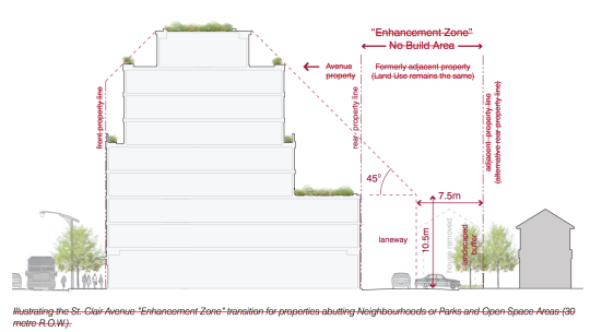
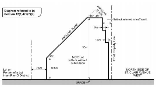
    To give you a visual for what I’m talking about, here’s a section drawing from a zoning by-law that was adopted by City Council for St. Clair Avenue West in midtown:

    image

    Here you can quickly see that if you were dealing with a shallow lot of, say, 25m in depth, you wouldn’t have much left over after taking into account the rear property line setback (7.5m above), the front property line setback, and the 45 degree angular plane. Now you’re beginning to see why I said that it is easier said than done to play creatively within the guidelines envelope (thick black line above). When you look at the feasibility of these projects, you quickly end up getting pushed right up against the glass.

    But this is where Enhancement Zones comes in. 

    The idea here is that an adjacent low-rise residential property (or pair of properties in the case of attached houses) could be included in mid-rise development proposals to create a deeper site that then meets the requisite separation distances between the mid-rise scale and the low-rise scale. To be clear, nothing would be built in the Enhancement Zones. They would just help to relieve some of the setback pressures from the original shallow lot and maybe even create a rear laneway system where one did not exist before.

    Below is a drawing from the Mid-Rise Buildings Study showing that new condition. The same 7.5m setback applies at the rear, but now it sits within an Enhancement Zone – formerly an adjacent and separate property. All the text is crossed out because, again, this standard was not adopted.

    image

    From a mid-rise development and feasibility standpoint, this makes a lot of sense. Sites that may have been un-developable before, now become developable. This makes it easier for us to achieve the European-scaled mid-rise vision that Toronto has for its avenues.

    But for reasons that I am sure you can guess, there are concerns with this performance standard. Probably the most obvious is that, to a certain extent, it destabilizes “neighbourhoods.” And they are intended to be completely stable entities that see little to no intensification. As soon as you allow this to happen, properties sitting in Enhancement Zones would become the prey of developers.

    However, there are counter arguments you could make. The owners of these properties would likely receive offers above market value. So maybe they end up better off. At the same time, you could also argue that the more development we unlock outside of “neighbourhoods”, the more stable they can actually remain.

    In any event, I’ve been thinking about this lately and I thought it would be interesting to debate the pros and cons of these magical-sounding Enhancement Zones. For those of you inclined to engage in geeky planning discussions, I’d love to hear from you in the comments.

  • Do you podcast?

    I have never really gotten into podcasts. 

    Sometimes I listen to The Urbanist on Monocle Radio when I’m puttering around my place, but generally speaking I don’t consume a lot of content in this format.

    Part of this might be because I don’t have a commute (commuting sucks) and I don’t drive enough that I feel the need to fill my time with stimulating things. 

    Sometimes I also find it hard to do other meaningful things at the same time. I just want to sit and listen attentively. (That probably speaks to my multitasking abilities.)

    But every now and then I feel like I should be taking more advantage of all the information embedded in podcasts.

    So below are three that I’m going to try and listen to more often and that you might also enjoy. If you know of any great podcasts, please share them in the comment section below.

    If you can’t see the embedded podcasts below, you’ll need to visit this blog post on the web.

    99% Invisible with Roman Mars

    [soundcloud url=”https://api.soundcloud.com/tracks/252094403″ params=”auto_play=false&hide_related=false&show_comments=true&show_user=true&show_reposts=false&visual=true” width=”100%” height=”450″ iframe=”true” /]

    The Urbanist on Monocle 24

    [soundcloud url=”https://api.soundcloud.com/users/25784122″ params=”auto_play=false&hide_related=false&show_comments=true&show_user=true&show_reposts=false&visual=true” width=”100%” height=”450″ iframe=”true” /]

    Unlisted with Brand Inman (Real Estate)

    [soundcloud url=”https://api.soundcloud.com/tracks/254352869″ params=”auto_play=false&hide_related=false&show_comments=true&show_user=true&show_reposts=false&visual=true” width=”100%” height=”450″ iframe=”true” /]

  • A short history of redlining

    In 1933, the United States Congress created the Home Owners’ Loan Corporation (HOLC). With foreclosures rising as a result of The Great Depression, the task of the agency was to provide new low-interest mortgages to both homeowners and private mortgage lenders. Between 1993 and 1936, the agency served about one million households.

    By 1935, the parent company of the agency (the Federal Home Loan Bank Board) decided to initiate something called the “City Survey Program.” The idea was to look at local real estate trends – including the racial and ethnic composition of the country’s largest cities – in order to get a better understanding of how to manage all of these outstanding loans.

    One outcome of this program was the creation of the HOLC’s infamous “residential security maps.” (Philadelphia’s is shown at the top of this post.)

    These were maps that categorized city neighborhoods according to 4 grades. Grade A neighborhoods (green) were the best ones. They were ethnically homogenous and had room to be further developed. Grade B neighborhoods (blue) were the second-best ones. They were already completely developed, but were still considered desirable. Grade C neighborhoods (yellow) were starting to decline and showed an “infiltration of a lower grade population.” And finally, grade D neighborhoods were considered “hazardous” and colored in red. These neighborhoods had low homeownership rates, old crappy housing, and an “undesirable population”, which, at the time, largely referred to Jews and African Americans.

    Some have argued that the HOLC and their “residential security maps” are what kicked off systematic mortgage discrimination in America’s inner city neighborhoods – later referred to as “redlining.” This was the practice of denying credit to people who lived in these undesirable neighborhoods (and even to real estate developers who wanted to build in these undesirable neighborhoods).

    But University of Pennsylvania professor Amy Hillier has argued that these maps simply reflected the ethos of the time period. Using a sampling of HOLC mortgages, she found that 62% of them were issued to grade D (red) neighborhoods. The agency, itself, was not actually redlining in practice.

    Furthermore, she also looked at private mortgages issued in Philadelphia between 1937 and 1950 and found that security grade rating actually had no impact on the total number of loans issued. She did, however, discover slightly higher interest rates for properties located near and in the bottom security grades.

    All of this is to say that “redlining” is likely not the only culprit for inner city decay. There are other factors at play.

    To that end, the National Bureau of Economic Research recently published a working paper, which I discovered through CityLab, called, “Racial Sorting and the Emergence of Segregation in American Cities.” The key finding here is as follows:

    “Our preferred estimates suggest that white flight was responsible for 34 percent of the increase in segregation over the 1910s and 50 percent over the 1920s. Our analysis suggests that segregation would likely have arisen in American cities even without the presence of discriminatory institutions as a direct consequence of the widespread and decentralized relocation decisions of white urban residents.”

    In other words, it wasn’t just mortgage discrimination; it was also just general discrimination. That actually makes a lot of sense, because, if you think about it, the former couldn’t have occurred without the latter being present.

    Here’s how the research paper puts it (via CityLab):

    “Policies that reduce barriers faced by blacks in the housing market may thus not prevent or reverse segregation as long as white households have the ability and desire to avoid black neighbors.”

    (Note: Most of the information and data used in this post was sourced from the work and research of Amy Hillier.)

  • Thoughts on inclusionary zoning

    Ontario is looking to pass legislation that would allow municipalities in the province to implement something known as inclusionary zoning. If passed and should municipalities decide to use this tool (Toronto almost certainly would), developers would then be required and/or incentivized to include some percentage of affordable housing in their new market rate developments. 

    Politically, inclusionary zoning tends to be popular. It’s believed to be a way for governments to create new affordable housing using relatively small public subsidies. Not surprisingly though, the development industry generally hates IZ. It’s another cost that needs to be added to the development pro forma – though some municipalities rightly offset these additional costs with additional density, breaks on levies, and so on.

    What I always think about when this topic comes up is the broader economic impact of the land use policy. Because I’m suspect that it’s as simple as: mandate affordable housing; get more affordable housing for free. Generally there are always trade-offs.

    So here’s some reading material for you all this morning.

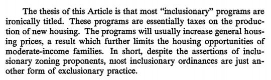
    In a classic paper (1981) by Yale Professor Robert C. Ellickson – called The Irony of Inclusionary Zoning – he argues that these practices can actually increase general house prices:

    image

    As a counterargument Owen Pickford over at The Urbanist argues that IZ simply reduces land prices as a result of the new tax. Land, after all, is the residual claimant. Therefore, he believes it’s an effective affordable housing policy. (I’m not so sure I believe that land prices would decrease in practice.)

    There’s also debate about the effectiveness of inclusionary zoning to actually deliver affordable housing at a meaningful scale. City Observatory wrote a post that looked at the total number of units produced (through IZ) across a number of American cities and the results were spotty. It should, however, be noted that not all inclusionary zoning policies are mandatory.

    Finally, the Furman Center for Real Estate & Urban Policy at New York University published a housing policy brief back in 2008 that looked at this exact topic. While they admit that the data is scarce, they come to the conclusion that IZ had no meaningful impact on the prices and production of single-family housing in San Francisco, but that IZ seems to have slightly decreased production and slightly increased pricing in the suburbs of Boston.

    What this last point suggests is that inclusionary zoning policies are not all created equal. So like all difficult questions, the answer to this one is likely: it depends. If anyone can point me to better data on inclusionary zoning, I would love to see it.

  • Developer Profile: The Adir Group

    In 2010, Gal and Tania Adir, aged 23 and 24, respectively, began renovating high-value apartments in central London.

    Today, they are known as The Adir Group and have about £50m in development under way.

    But more than just a developer, the group has grown to become “the parent company of a quickly expanding collection of complementary brands bound together by a desire to enhance people’s lifestyle through quality and beauty.”

    In addition to G&T (their residential development arm), they also founded Net.Works (a co-working space) and Nuper (a co-op living scheme). This last focus isn’t up on their website yet, but I read about it on Michael Mortensen’s blog. The goal of Nuper is to create affordable living solutions for young talent in London.

    I wanted to profile The Adir Group because I think it’s incredible how young they were when they got started (I was just starting graduate school at 23) and because I like their approach of creating a collection of complementary companies.

    I am excited to see where the next generation of developers (myself included) take this business. Already we are seeing some new approaches emerge.

  • Easier said than done

    Earlier this week I saw the Chief Planner of Toronto, Jennifer Keesmaat, tweet this out:

    //platform.twitter.com/widgets.js

    I responded with the below quote retweet because I figured I should probably devote a blog post to this topic and not just a tweet.

    //platform.twitter.com/widgets.js

    Now, I don’t know for sure, but I am guessing that her tweet was in response to the criticism from architects and developers that Toronto’s design guidelines are creating homogenous architectural outcomes. Some people – and I’ve written about this before on ATC – believe they’re too prescriptive.

    So today I’d like to talk about why playing creatively within the guidelines/zoning envelope, particularly at the mid-rise scale, is a lot easier said than done.

    Generally speaking, the value of land is dependent on what you can do with it or, in this case, what you can build on it.

    If all you could do was plant things on it, then the value of the land would be correlated with crop yields. If on the other hand you could build a building, it would be correlated, at least in theory, with the amount of space you could build and the rents you could charge for that space.

    Of course, this isn’t a perfect science. That’s why I said “in theory.”

    Landowners obviously want to maximize the value of their asset when it comes time to sell. So they, along with their brokers, will naturally try and stretch what is possible with the land. Why else do you think the best neighborhoods seem to magically grow new boundaries?

    When you combine this with the fact that mid-rise buildings are inherently less efficient to build and with the fact that their smaller size creates diseconomies of scale, it can be exceptionally difficult to find development sites where the numbers make any sort of financial sense. That is, even if you “maximize the envelope” and push rents or sale prices.

    So, with all due respect, not maximizing the envelope is almost unthinkable, unless you somehow managed to get a bargain on the land.

    Many of you will likely respond in the comments saying that all of this is simply a result of real estate developers being greedy capitalist pigs. But what we are talking about is no different than in any other competitive business environment. 

    Developers rent and sell products – albeit products that take an incredibly long time to make and bring to market. To make those products, there are a many costs, ranging from the cost of land to the cost of drawings. But hopefully within all of those numbers sits a profit margin that makes sense given the amount of work and risk that the developer has taken on. 

    Put differently, telling developers not to maximize the envelope is like telling a pizza maker to throw out 10-15% of her dough before she makes every pizza – even though she already (over)paid in full for the dough.

    If you’ve ever created a development pro forma, you’ll know that it’s not easy getting the numbers to work when you’re operating in a competitive market. This is not a knock against creative design. Trust me, I am a design snob. This is just business.

  • NO TOWER on Commercial Drive

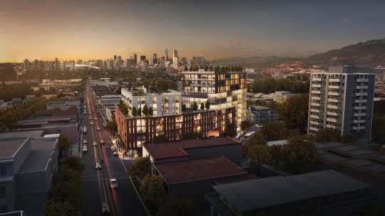
    For the past week or so I’ve been seeing the proposed Kettle Boffo Project in Vancouver make the rounds online. Here’s a rendering of the project, which is located at Commercial Drive and Venables Street:

    image

    The reason it has been making the rounds is that a community group called NO TOWER (written in all caps) has come out in fierce opposition of the 5 to 12-storey building. They have over 3,500 signatures.

    As an outsider looking in, this is surprising. The scale of the project seems appropriate. The height roughly matches the existing building shown above to the right. It may even be lower. And the project will provide somewhere around 30 social housing units, as well as additional space for the Kettle Friendship Society non-profit, who are currently on the site. (Note: An application to the city hasn’t yet been made.)

    What this has me thinking about is the push and pull between bottom-up and top-down planning. 

    When architect Bjarke Ingels talks about his Dryline project in New York, he likes to refer to it as the love child of Robert Moses (top-down planning) and Jane Jacobs (bottom-up planning). In the case of this project, it’s because it’s a large infrastructure project that they are trying to root into the local neighborhoods. Makes sense.

    But this same thinking could also apply to overall city building. Local communities rightly have their own wants. But at the same time, cities need to be thinking about the overall. The challenge is finding that right balance.

    I would be curious to hear your thoughts on the Kettle Boffo Project in the comment section below – especially if you’re from Vancouver.

  • Ziggurats and gondolas

    Yesterday was an exciting day for Toronto city building announcements. 

    Firstly, Alex Bozikovic of the Globe and Mail published an exclusive preview of architect Bjarke Ingel’s plan for King Street West. Here’s a photo of the architectural model (it’s by Landon Speers):

    My favorite quote from the article is this one from Bjarke:

    “It would be sad if the most diverse city in the world had the most homogenous real estate.”

    It’s true.

    For those of you who emailed me about the details of his talk next week (there were a lot of you!), I believe I emailed you all back. But in case I missed some of you, you can click here for the event details. I should have included it in my original post about BIG, but I thought the event was already oversubscribed.

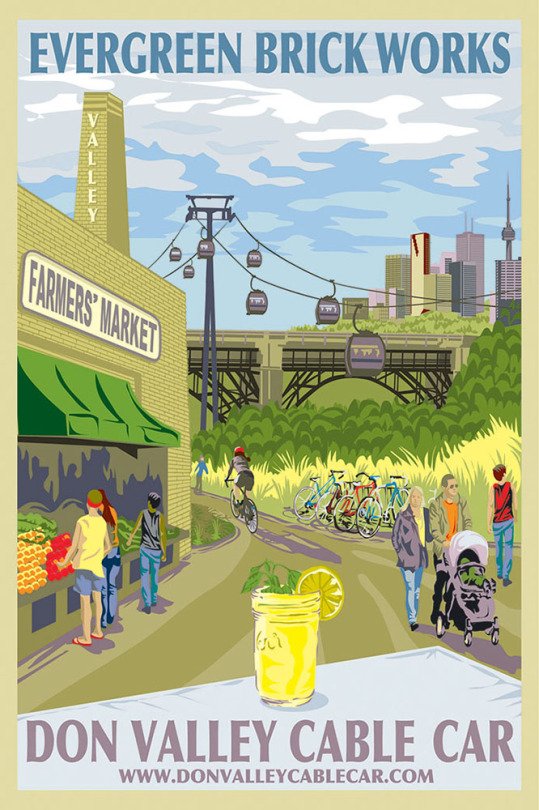
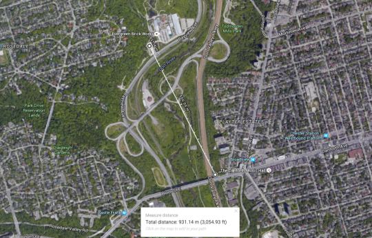
    Secondly, a private company called Bullwheel International Cable Car Corp. has just proposed to build a $20 to $25 million gondola running from Danforth Avenue (near Broadview subway station) to the Evergreen Brickworks. The total length would be almost 1 km and it, allegedly, wouldn’t require any public money. Here is their website.

    The timing of this proposal feels a bit serendipitous to me. When I was in Park City, Utah a few weeks ago, snowboarding right into the town and then taking their “town lifts” back up to traverse the mountain, I remember thinking to myself: what a wonderful form of transportation this is.

    Of course, Park City has giant mountains and Toronto, unfortunately, does not. But we do have spectacular ravines and a spectacular institution known as the Evergreen Brickworks.

    But one of the challenges with our ravines is that they can be a bit hidden – particularly for visitors to the city. Part of this is because we are trying to figure out the right balance between natural preservation and active use. But that’s one of the things that makes this proposal so intriguing. It’s a way to celebrate our ravines and natural landscape, without physically encroaching it.

    Here’s a map of the proposed gondola path:

    What do you think about these announcements?