Daily insights for city builders, delivered every morning at 6 AM ET. I’m Brandon Donnelly — a Toronto-based real estate developer and founder of Globizen. I’ve been writing here since 2013.

Tag: density

  • 8 standards for transit oriented development

    Recently in the comment section of ATC, Lloyd Alter of Treehugger shared a great article talking about the 8 principles of Transit Oriented Development (TOD). “TOD” is one of those buzzwords (or buzz acronyms?) that gets thrown around a lot in city building and real estate circles. But I suspect that most people don’t exactly know what it takes to design and build successful TOD projects and neighborhoods.

    Which is why the Institute for Transportation and Development Policy came up with these 8 standards:

    1. WALK: Develop neighborhoods that promote walking
    2. CYCLE: Prioritize non-motorized transport networks
    3. CONNECT: Create dense networks of streets and paths
    4. TRANSIT: Locate development near high-quality public transport
    5. MIX: Plan for mixed use
    6. DENSIFY: Optimize density and transit capacity
    7. COMPACT: Create regions with short commutes
    8. SHIFT: Increase mobility by regulating parking and road use

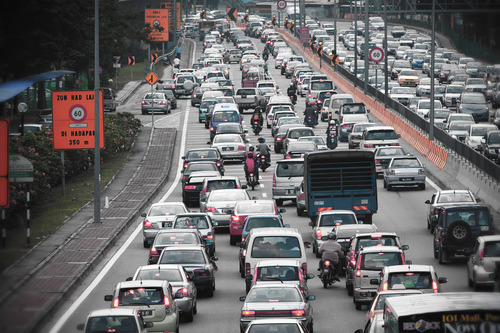
    What should be apparent from this list is that the standards are quite clearly stacked against cars. Number 2 is about prioritizing non-motorized transport networks. And number 8 is about regulating parking use and road use. It’s about making a decision who you are planning for and acknowledging that when you do all of the above, you largely eliminate the need for driving.

    If you’re a “war on the car” kind of person, this might offend you. But if you look at the data I shared about a week ago (forgive me, I know the chart is a pain to read), you’ll see that it’s seemingly pretty difficult to design a city that’s equally great for both cars and for people. The cities where people love to walk, cycle, and take transit are precisely the ones where few people drive.

    Image: Flickr

  • Looking at Berlin from the back of a napkin

    image

    Depending on who you ask, the current condo boom in Toronto might be viewed as either a good thing or a bad thing (most will have an opinion). Some people think we’re simply building too many condos. And that too many of them are small, crappy, and geared towards investors – as opposed to end-users.

    While I do agree that we could be doing more to create complete communities – that is communities which serve everyone from young singles to families with 3 kids – I think there are also a lot of positives associated with Toronto’s condo obsession (full disclosure: I’m a real estate developer). It has made us more sustainable, more reliant on alternate forms of (non-car) transport, and it has made us a generally more exciting place to live.

    But that doesn’t mean we can’t do better.

    Lately I’ve been wondering about how other cities do it. Specifically, those European cities that somehow seem to always be able to build awesome housing projects. So today I thought I would pick one and profile it. What I really wish I had was a financial pro forma to share with you all, but in the absence of that, I’ll try and back into some of the numbers on my own.

    image

    Shown above is the 9-storey Charlotte Apartments in Berlin. It was developed by WI Concept and designed by Michels Architecture Office. I chose this building because I think it’s an attractive one and because it’s of the (mid-rise) scale that Toronto is trying to promote along its many avenues. Here are the stats I was able to find online:

    • Site area: 347 square meters / 3,735 square feet
    • Building area: 3,000 square meters / 32,291 square feet (says gross floor area, but I don’t know if that means the same thing as it does here)
    • Construction costs: €3.6 million / C$5,065,691 (as of today’s rate)
    • Units: 28 (sold within 1 week of launch)
    • Market: ~70% of buyers in Berlin are believed to be foreign investors

    Now, if we were actually building a development pro forma, we’d want to get a lot more granular in our calculations than what I’m about to do. We’d want to know gross construction area, net saleable areas, and so on. But for the purposes of this post (and because I have very little information), I’m going to simplify and do a back of the napkin set of calculations.

    Based on above, the FSI (or density) is about 8.65 (32,291 sf / 3,735 sf). That’s roughly in line with many of the residential developments we’re seeing in downtown Toronto. The average unit size works out to be about 1,153 sf (32,291 sf / 28 units), but in reality it would be less if that 32,291 number is truly the gross floor area. You would need to subtract the corridors and other non-saleable areas from it before doing this calc. Either way, that is big compared to most downtown Toronto condos, but small for Berlin standards according to this ArchDaily article. Finally, if we look at construction costs, we get $157 per square foot in Canadian dollars ($5.065M / 32,291 sf). That’s low. I wonder what the land costs were.

    Again, these numbers are rough rough. But I wanted to try and dissect a European development project and compare it to Toronto. The most surprising figure seems to be the low construction costs. If you have any additional insights, I would love to hear from you in the comment section below.

    Images: Werner Huthmacher

  • Comprehensive to the core

    The City of Toronto recently started an initiative called “Comprehensive to the Core.” It’s a look at how downtown Toronto–which is growing at 4 times the rate of the rest of the city–should continue to grow moving forward so that it remains a great place to live, work, learn and play.

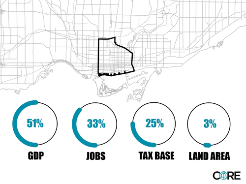
    Here’s a presentation that was delivered last month by the city. It’s mostly infographics and so it’s a quick and fun read. And here’s an infographic that does a nice job of summarizing what’s happening in the core of Toronto.

    What it’s saying is that downtown Toronto–which they consider to be bound by Bathurst Street in the west, the Don Valley Parkway in the east, the lake in the south, and Dupont Street in the north–is responsible for 51% of the city’s entire GDP. It’s also responsible for 33% of all jobs in the city and 25% of the city’s entire tax base. And yet in terms of size, it represents only 3% of the city’s land area.

    That’s a powerful reminder of the economic potential of density and agglomeration economies. It’s also a reminder that we shouldn’t let politics deprive our economic engine of the services and investments it needs.

  • Toronto mayoral candidate announces regional express line

    image

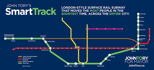
    Yesterday Toronto mayoral candidate, John Tory, proposed a transit line called SmartTrack. It’s part of his One Toronto transit plan. If you’re interested in watching the full 30 minute announcement, click here.

    As somebody who came out of the gate as a strong proponent of the “Yonge Relief Subway Line” (and as somebody I immediately supported for that reason), this proposal first hit me yesterday as a disappointment. Not because I don’t think we need a regional express rail network in the region (we do), but because I feel that he is backing away from that initial commitment and depriving the core of the transit infrastructure it needs.

    As soon as I found out about the plan, I immediately emailed one of my friends at Metrolinx. I told him I thought it was an “epic fail”. He pushed back and asked me to consider the merits of Tory’s plan. After having slept on it (and calmed down), I’m now prepared to talk about both the benefits of SmartTrack and why I was disappointed. 

    SmartTrack is basically a regional rail plan, intended to move people from the outer and inner suburbs to and from downtown using an integrated fare system. That is, riders will not have to pay a separate fare to transfer from subway to SmartTrack. 90% of the track needed for the plan is already existing, which means it will be cheaper and quicker to build compared to the full relief subway line. It will also bring employment centers such as Airport Corporate Centre in Mississauga into the transit network. For these reasons, the SmartTrack plan would certainly be beneficial for the region. 

    But, there’s a densities mismatch.

    If you look at the number of stops proposed in Scarborough and Markham, and compare it to the number of new stations proposed for downtown (1 – Spadina station) and the downtown shoulder neighborhoods (2 – Liberty Village and the Unilever site), the plan starts to look lopsided. SmartTrack would help residents of downtown get out to the suburbs, but it would do little to help them move in and around the core.

    If you look at the way Toronto is intensifying on a map, it looks like an upside down letter T. Density now hugs the waterfront and then follows our subway lines up north. I believe that the SmartTrack plan would help to relieve the pressures on those subway lines, but I don’t think it adequately addresses the bar of the T that now runs parallel to the lake.

    So while I do think that the Toronto region would be well served by regional express rail, I don’t think we can forget about the central part of the city. This shift in focus may have something to do with where Tory believes his voter base now sits, but let’s not forget that there’s a strong correlation between population density and transit ridership levels. 

    Now, let’s hear from you. What do you think of Tory’s One Toronto plan and SmartTrack proposal?