Daily insights for city builders, delivered every morning at 6 AM ET. I’m Brandon Donnelly — a Toronto-based real estate developer and founder of Globizen. I’ve been writing here since 2013.

Tag: biking

  • From bicycles to cars in Beijing

    image

    Earlier this week, a friend of mine shared this TED talk on my Facebook wall talking about the state of climate change in the world. The talk is by Nicholas Stern. And at one point he talks about the incredible urban transformation that has taken place in Beijing over the last couple of decades; specifically, the shift from a bicycle oriented city to a now automobile oriented city.

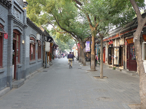
    I knew that this was the case, but it got me thinking. Because alongside this mobility change, there’s also been – not surprisingly – pronounced changes to the urban fabric of the city. The most significant is perhaps the demolition of the city’s hutongs and siheyuan. Hutongs are basically narrow alleys (see above photo) and siheyuan are the traditional Chinese courtyard houses.

    For centuries, these alleyways and courtyard houses have defined Beijing. And while I realize that not all of them were as glamorous as Melbourne’s laneways, only about 1,000 of Beijing’s original 6,000 hutongs remain (according to Time). Which makes me wonder: Is China making the same mistakes that we made in the 20th century?

    Because as the developed world moves toward transit oriented development, bike lanes, heritage preservation, and compact urban living, China has seemingly gone and done the exact opposite. They got everyone off bicycles and into cars, and they went and erased a scale of urbanism that has been in place for centuries.

    This is not to say that China doesn’t deserve to have the same standard of living as the developed world. It absolutely does. It just seems a bit ironic to me that the things we’ve become sharply critical of, are exactly what China seems to want to recreate.

    Image: Flickr
  • Seattle’s first protected bike lane makes a quick adjustment

    Seattle recently installed its first protected downtown bike lane on Second Avenue. Here’s a short video of it in action (pay attention to the signalling setup and the pedestrians that walk into the bike lanes). Click here if you can’t see the video below.

    [youtube https://www.youtube.com/watch?v=x2iQCCHlR0s?rel=0]

    Shortly after it opened, they quickly discovered that the left green arrow and solid green circle (shown above) were confusing drivers. The intent was for the left green arrow to signal that you could turn and for the solid circle to signal that you could drive straight ahead.

    But even with the accompanying sign, drivers kept getting confused and thought a green circle meant you could go wherever you want.

    So the Seattle Department of Transportation quickly adjusted and changed the green circle to a north arrow. And it seems to have fixed the problem. I think it goes to show how important the details can be with these things. 

  • The war on the car

    image

    In today’s post I’d like to focus on the second tweet I embedded in yesterday’s piece about downtown Toronto. Specifically, the fact that almost 75% of downtown residents walk, cycle, or take transit to work, leaving drivers firmly in the minority.

    For me, this then makes me question whether or not we’re optimizing well enough for the majority. However, it’s often not that simple. And that’s because the downtown core is clearly regional in its draw, and the further you move out from the downtown core, the more the modal split flips. In the suburbs, driving is obviously the majority.

    And herein lies the tension and the reason for all this “war on the car” rhetoric: We have a downtown core with completely different mobility preferences than the rest of the region.

    But as Toronto continues to intensify and grow (the population of the Greater Toronto Area is projected to reach almost 9 million by 2036), I truthfully don’t know how we could reasonably expect to (efficiently) move that number of people in private cars. I’ve just never seen it done before.

    Some people think that if we simply got rid of all those damn streetcars on our city streets, that we’d be doing a lot to eliminate traffic congestion. But it’s not that simple. The Highway 401 here in the city is already 18-lanes and one of the widest in the world. And yet it’s perpetually clogged. No streetcars there.

    So I look at this tension as a growing pain. Sooner or later I think we’re going to realize that this war should really be a war on inefficiency. How do we move lots of people around big cities while minimizing waste, maximizing economic output, and enhancing quality of life?

    Now that’s a war worth fighting.

    Image: Helibacon

  • Toronto approves 755 storeys of new development

    image

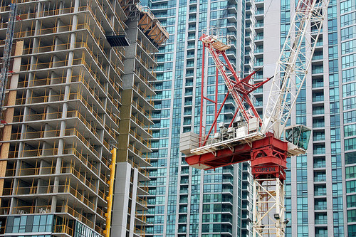
    Earlier this week, Toronto City Council approved the equivalent of 755 storeys of new development, a lot of which will end up in the downtown core. The translates into 6,887 new housing units and roughly 4 million square feet of new commercial space. The Globe and Mail called it the Manhattanization of downtown.

    If you’d like to go through the complete City Council meeting agenda, you can do that here. (I warn you though, it won’t be an exciting read.)

    One notable project that was approved is 50 Bloor Street West, which is a 71-storey mixed-use building in Yorkville adjacent to and on top of Holt Renfrew (It includes a $6 million Section 37 contribution). I mention this one because it’s impressively tall and because it’s a project that I was involved with when I was at Morguard. Watch for Yorkville in the coming years, there’s a lot in the pipeline.

    While I think this is all incredibly exciting, our chief planner, Jennifer Keesmaat, is entirely correct in pointing out that all of this highlights the desperate need for better infrastructure, the most critical of which is a relief subway line that cuts across downtown.

    But to be clear, this isn’t a question of just planning for growth. This is a question of planning for growth and making up for decades of infrastructure disinvestment. That’s the position we’re in today, which means we have a lot of hard work to do. Though I’m confident we’ll get it done.

    The other thing that this level of intensification should highlight for you is that public transit, and other forms of mobility such as biking and car sharing, have to be central to our goals. It’s simply infeasible for everybody to be driving around in a car. We’re currently demonstrating how efficient that ends up being.

    So as Toronto continues to intensify, I think we’ll quickly discover that traffic and private cars aren’t the answer or even the right question to be asking.

    Image: Flickr

  • What to do when a car is blocking your bike lane

    I was out for a bike ride last night and, on my way home, I decided to try out the new dedicated bike lane on Adelaide Street. Usually I would take King Street, but it was completely full because of Caribana parties.

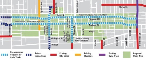
    For those of you who may not be aware, the city of Toronto is currently piloting two dedicated bike lanes on Adelaide Street and Richmond Street in the downtown core. Both streets are one-way and because the lanes were so big to begin with (highway-like spacing), I’m told that these new bike lanes didn’t even eat up a driving lane.

    Here’s a map of the pilot area:

    image

    Given that dedicated bike lanes are a scarce resource here in Toronto, I have to say that it was rather luxurious having my own piece of road. And because there’s no longer any fear of parked car doors swinging open, I was able to ride a lot faster than I normally would. 

    But as my friend Evgeny pointed out earlier this week, there’s a big difference between dedicated and grade separated bike lanes. Indeed, on my trip from Bathurst Street to Church Street last night, I encountered 3 cars parked in my lane.

    //platform.twitter.com/widgets.js

    So, I hope that these bike lanes become a permanent fixture downtown, but that the city makes them grade-separated. I’m sure people will use them. At the same time, I think they could also act as a catalyst for more pedestrian life along both of these streets.

    If you haven’t yet tried them out, I would encourage you to do so. The city is tracking usage and so you would be supporting the cause. And if there’s anybody parked in your lane, below is one way to handle it. It’s a video by Casey Neistat out of New York. If you can’t see it below, click here.

    [youtube https://www.youtube.com/watch?v=bzE-IMaegzQ?rel=0]

  • How mobile apps are going to help us build better cities

    image

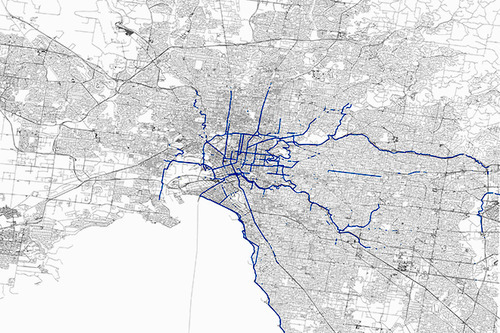
    Some of you might know that I’ve recently started using a mobile app called Strava. It’s a platform that allows you to track your runs and bike rides, as well as those of your friends. It tells you your speed, elevation changes, and it also maps your trips–among many other things. Here’s what my 50 km ‘Ride for Heart’ looks like from last Sunday.

    But what’s even more interesting is how cities are starting to use the data this app collects:

    For $20,000 a year, transportation planners and others can access Strava Metro, which provides an unprecedented look at where and how people are biking. It can tell them where they speed up and slow down, for example, or where they might stay in the street or ride on a crosswalk. That information can reveal where bike lanes or traffic calming measures would be useful, and if those already installed are effective.

    It’s a perfect example of how “tech” is infiltrating so many other sectors. Mobile technology and networks are generating huge amounts of data and it’s happening at an increasing rate. We’re gaining insights into the way people live that simply wasn’t possible before. Some of this information will inevitably be misused, but a lot of it will be used to improve the way we live our lives.

    I know that the City of Toronto also has its own proprietary cycling app and is hoping to collect similar sorts of data from it. But intuitively, I don’t think they’ll be able to compete with the scale of a platform like Strava. Though I certainly applaud the initiative.

    The information age is an exciting time.

    Image: Strava via Wired

  • We want what we want

    This past Sunday night I was out for a bike ride with a few friends all around downtown Toronto. According to Strava, we did almost 22 km. Click here to see our route. During the ride, one of my friends said something to me that stood out. He said that when he’s on a bike he wants all cars off the road; but when he’s in a car, he wants all bikes off the road.

    Now, this may seem like a fairly banal statement, but I think it demonstrates a number of things about people and the way we interact with cities. First, we’re all probably pretty selfish. We want what we want at a specific moment in time and we easily forget what it’s like to be on the other side of a situation.

    Second, I think it reinforces what I wrote a month ago in a post called: Every street can’t be everything to everyone. If we want to improve the user experience for a variety of different use cases (driving, biking, walking and so on), we should decide when and where we’re going to optimize for each. 

    The reason my friend said what he said was because we were riding on a road with no bike lanes. We were swerving in and around cars. And when the street is shared like this it naturally becomes a competition of who can be the most aggressive and dominate the road–bikes or cars. But as exciting as that might be, it’s probably not an ideal way to build our cities.

  • Minimal effort; maximum engagement

    I’ve been blogging almost every day for 3 months straight. It’s been a hugely rewarding process and I absolutely plan to continue. Though some days it’s hard to find something to write about. And some days it’s hard to find the time.

    One of those days was 5 days ago. I was busy and so I decided to post a video instead of spending a lot of time writing a post. I posted a video explaining how the Dutch design their street intersections to accommodate cyclists. You can find that post here.

    Well, it turns out that the post I easily spent the least amount of time preparing has now become, by far, the most popular post I’ve ever done. As of today, I received 460 notes via Tumblr. That includes likes and reblogs. And, as a result, my engagement graph now looks like this:

    I can’t even make out what the numbers were before this post blew up. This is really interesting to me, because I remember questioning if I should even post the video in the first place. I thought it may be a bit dry and perhaps too technical.

    It just goes to show that sometimes you can’t predict what will catch on.

  • [youtube http://www.youtube.com/watch?v=FlApbxLz6pA?wmode=transparent&autohide=1&egm=0&hd=1&iv_load_policy=3&modestbranding=1&rel=0&showinfo=0&showsearch=0&w=500&h=281]

    Want to know how the Dutch design their intersections so that they’re friendly for cyclists? Then check out this video. It’s amazing what you can achieve when you actually care about something and you put thought and intent into it.