Daily insights for city builders, delivered every morning at 6 AM ET. I’m Brandon Donnelly — a Toronto-based real estate developer and founder of Globizen. I’ve been writing here since 2013.

Tag: barcelona

  • How do you make a street less touristy?

    La Rambla is arguably Barcelona’s most famous street. It’s a tree-lined street that runs 1.2 kilometres from the Plaça de Catalunya in the north to Port Vell in the south. Its origin dates back to the 15th century when the original stream was drained and the semblance of a street started to emerge.

    In the centuries that followed, the street came to serve as an important anchor for urban life in Barcelona. It provided a spine of open space within a dense medieval fabric of narrow streets. But alongside the rise of Barcelona as a global tourist destination, the street came to be seen more as a place for tourists than as a place for local urban life.

    This desire to create more “sustainable tourism” is one of the impetuses behind the ~€56 million revitalization project that is currently underway and is expected to be completed in 2027.

    But this raises a fascinating city-building question: How do you actually make a street less, you know, touristy? Tourists like visiting Barcelona and walking on this street, and so aren’t business owners going to just naturally cater to them? And aren’t landlords just going to rent to whoever will pay the highest rents?

    Here’s some of what Barcelona is doing:

    • Transversal flows: This one is fascinating to me. It was found that tourists tend to walk the street longitudinally (up and down), whereas locals tend to walk it transversally. In other words, locals are more likely to cross it coming from one of the surrounding neighbourhoods. The new design now privileges these more local flows.
    • Expanded pedestrian zones: Car traffic is being reduced to one 3.5-metre lane in each direction. This frees up more space for pedestrians, which is expected to help with overcrowding.
    • Room for culture: Dedicated spaces are being created to allow for more cultural programming. This is also part of a broader strategy to elevate the kind of tourism that the city receives.
    • Commercial licensing restrictions: As I understand it, the city is actively working to limit the licenses given out to souvenir shops (and the like) along the street. A meaningful amount of retail is also housed in kiosks and stands within the public right-of-way, where the city has even greater control.
    • Mercat de la Boqueria: One of the main anchors on La Rambla is the publicly owned market. But over the years, the product mix started to skew toward ready-to-eat foods and other to-go products designed for tourists. New restrictions have been put in place, or will be, that cap tourist-oriented offerings at 50%, allowing more space for local shopping needs. Interestingly enough, I have read that the merchants were in favour of this cap because the emphasis on tourist products was driving down margins. You instead want people coming in and grocery shopping for their families.

    These are just some of the initiatives that are being undertaken to rebalance La Rambla and find a more sustainable equilibrium between tourists and locals. It also dovetails with some of the other broader moves that Barcelona has implemented, such as its short-term rental ban and the right of first refusal (ROFR) that it enjoys over certain buildings and homes in order to grow the city’s public housing stock.

    It’ll be interesting to evaluate the effectiveness of these moves once the street is complete. La Rambla has many centuries of history and it has always evolved alongside Barcelona. Today is no different.


    Images from Barcelona City Council

  • Mapping 15-minute cities

    This is an interesting map to play around with. It allows you to see how many 15-minute neighborhoods and cities there are around the world. And it works by calculating the average time it takes to walk or bike to the closest 20 points of interest in 10,000 cities. These points include all of the usual suspects like places of work, schools, healthcare institutions, grocery stores, and so on. A blue cell indicates an average walk time < 15 minutes, and a red cell indicates an average walk time > 15 minutes. The darker the color, the shorter or longer the average time in minutes.

    By this measure, it’s hard to beat many/most European cities. Here are Paris and Barcelona:

    The city propers are completely blue, and you have to go pretty far out (or up into mountains) to find areas that don’t have 15-minute conveniences.

    Toronto has a strong core and isn’t terrible overall, but expectedly, we aren’t as uniform and as deep blue as Paris and Barcelona:

    Where things get really interesting, though, is when you look at cities like Dallas and Houston:

    It’s clear where these cities stand on walkability.

  • Physical space is a funny thing

    It is often difficult to grasp. This is why when you look at an empty piece of land, it can sometimes be difficult to visualize actually fitting a building on it. And why when you look at an empty room, it’s common to think, “there’s no way that furniture will fit in here.” But in the end, it does fit.

    It also tends to be relative. Here in North America, it is common to argue over things like parking space dimensions and drive aisle widths. We’ll say things like, “well, people like their big cars.” But then you travel to Europe and you find streets like this:

    And this:

    The first is only marginally bigger than the width of a parking space in Toronto (2.6 meters). And the latter is only marginally bigger than the width of a typical two-way drive aisle (6 meters). So are these too small? Well, it depends on your perspective.

    If your basis of measurement is the size of cars, then these streets will seem too small. Cars also keep getting bigger, so you have this inflation factor to deal with. But if your basis of measurement is something else, such as walkability, then maybe they’re just right.

  • La Rambla

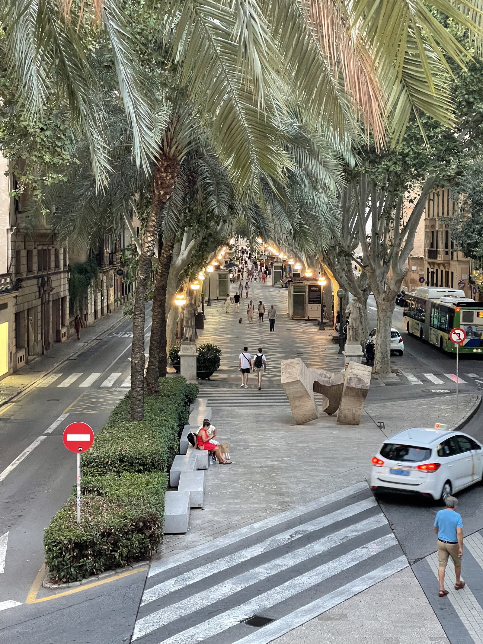
    It’s hard to think of Barcelona and not think of its famed street, La Rambla. But this same street design (and name) also appears in other cities throughout Spain. The above two streets are in Palma. The first is also called La Rambla (which is supposedly derived from an old Arabic word meaning sandy riverbed) and the second is called the Paseo del Borne. Both follow the exact same urban design principles. They’re broad tree-lined streets with a large center median dedicated to only pedestrians. All car traffic is relegated to the sides. What’s great about this design is the following. One, it reallocates public space according to who uses it the most (i.e. pedestrians). Two, it consolidates the main pedestrian realm (in lieu of just having larger sidewalks on either side of the street). And three, it establishes a clear hierarchy for the street. Pedestrians are most important here, and that’s why they get the center position. It’s surprising that more cities don’t adopt this same design.

  • Roncesvalles is a great, single-sided, street

    Roncesvalles Avenue is a successful north-south main street in the west end of Toronto. I say successful, because it is truly a great street. It has transit, bike lanes, a fine-grained built form, and lots of interesting retail:

    But it is somewhat unique in that a large section of it is a one-sided retail street. Meaning, it looks like this:

    This obviously isn’t a fatal flaw. It remains a wonderful street. And there are lots of examples of thriving one-sided retail streets. Ocean Drive in Miami Beach immediately comes to mind (notwithstanding the fact that locals tend not to go to it).

    But conventional retail wisdom does dictate that two sides are better than one. Consider this 2023 report by Cushman & Wakefield ranking the top global main streets across the world. All of the streets that I have been to before are two-sided:

    • 5th Avenue in New York between 49th and 60th (above 60th is, incidentally, when the street converts to single-sided because of Central Park)
    • Montenapoleone in Milan
    • The main street of Tsim Sha Tsui in Hong Kong
    • New Bond Street in London
    • Avenues des Champs-Élysées in Paris
    • Grafton Street in in Dublin
    • Passeig de Gracia in Barcelona
    • Bloor Street in Toronto

    These are all two-sided retail streets.

    None of this is to say that the west side of Roncesvalles has nothing going on. It has a diverse mixture of uses, including churches, libraries, apartments, and many other things. But I think there is still an argument to be made that it has been hamstrung by restrictive zoning.

    That said, Roncevalles is defined as a “major street” in Toronto’s Official Plan and so it does fall under the city’s new Major Street Study. Maybe that changes things.

  • Blocks and superblocks in Barcelona and Salt Lake City

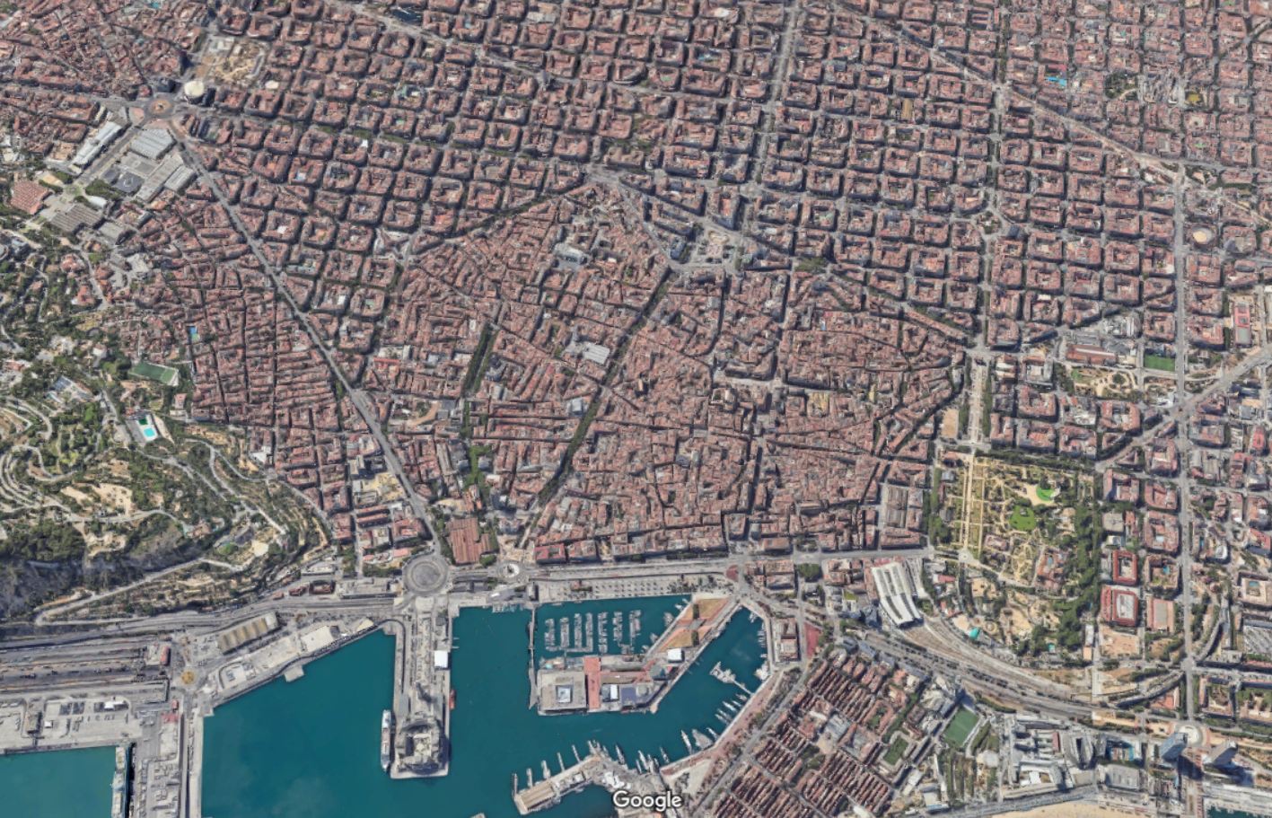
    Let’s continue with our theme of city blocks and talk about another city with a noteworthy street grid: Barcelona. Up until the middle of the 19th century, Barcelona was a tiny medieval city hemmed in by 6 km of walls and totalling just over 2 square kilometers. If you look at a map of the city today, it’s pretty easy to see where this was:

    This was of course done for military purposes. Barcelona’s medieval walls helped the city resist siege after siege. But the result was also overcrowding, unsanitary conditions, and a generally low life expectancy. So after much debate, it was eventually decided that the walls would need to come down and that the city would need to expand outward.

    This then raised the question: how should it be done?

    Enter a civil engineer named Ildefons Cerdà. Created in 1860, the Cerdá Plan for Barcelona was a continuous grid of blocks intended to guide the future growth of the city, similar to what the Commissioners’ Plan did for Manhattan. The blocks measured exactly 113.3 by 113.3 meters and each was to have a central open space of at least 800 square meters.

    In his original plan, the streets were to be 35 meters wide. But supposedly these were narrowed to no more than 20 to 30 meters due to criticism from the public. Wide streets and more lanes were, I guess, not seen as a benefit in the second half of the 19th century. Either this, or landowners simply wanted bigger buildings.

    The Cerdá Plan got approved in 1860 and, today, the city looks like this:

    One particularly unique feature of this plan was that the blocks all had/have chamfered corners. This improved visibility at the intersections, as well as created opportunities for public spaces and other uses. For better or for worse, today, you’ll find parking for cars and scooters, bike share stations, ramps leading to underground garages, patios, and more.

    The heights of the buildings on each block were also intended to be capped at a consistent height. But even with relatively few tall buildings, the Cerdà Plan led to one of the densest cities in Europe. Today, it is also viewed as a highly livable and desirable city. Hence why the city announced a total ban on short-term rentals. Too popular.

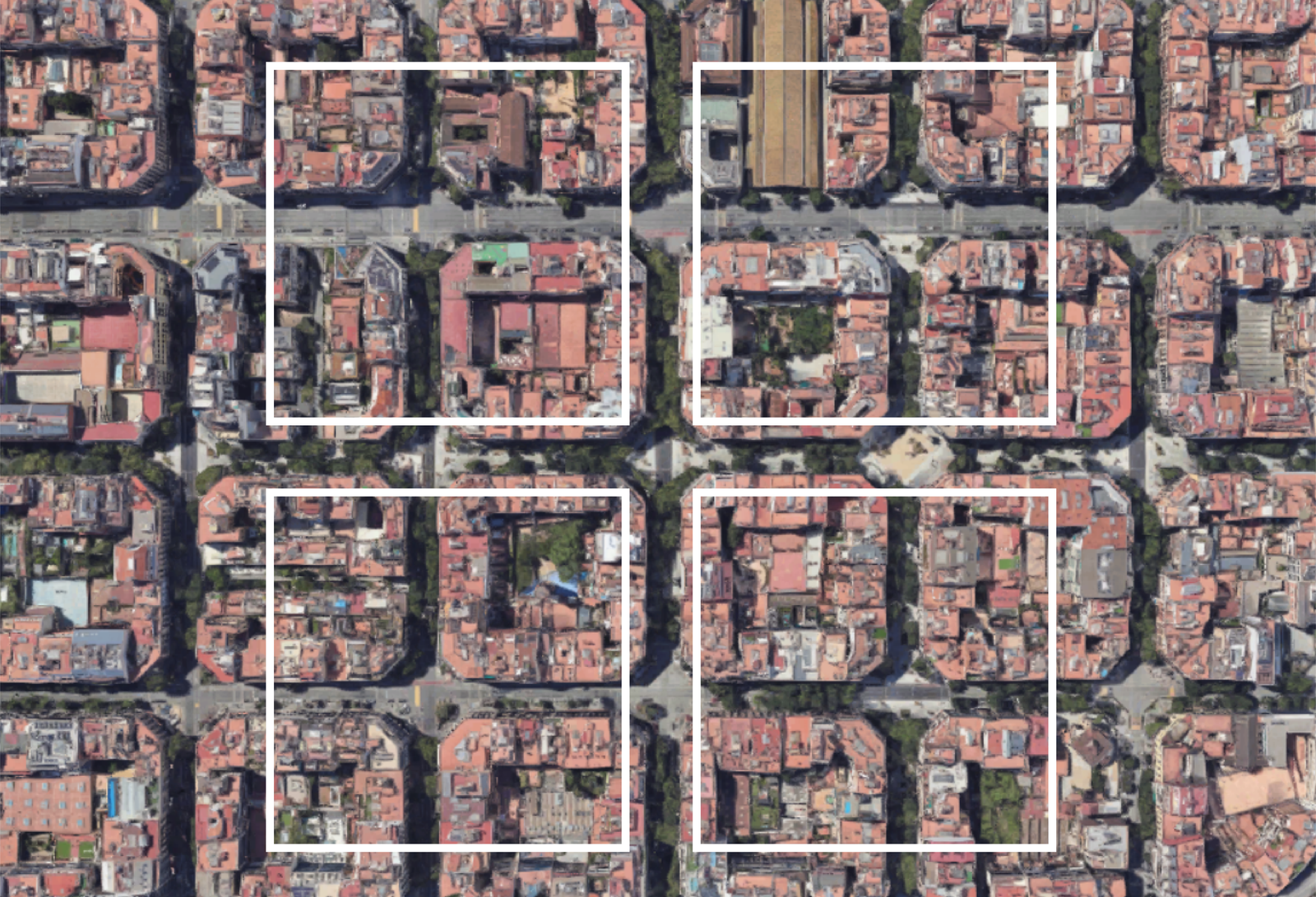
    Now for a comparison. Last week we spoke about Salt Lake City’s large city blocks (here and here). And so for fun, here’s what these blocks would look like on top of Barcelona:

    The most obvious takeaway is that Salt Lake City has larger city blocks than Barcelona, and that’s one reason why, objectively, Barcelona is more walkable and urban than SLC. But I think you could also view this graphic as a tremendous opportunity.

    Barcelona is in the midst of rethinking its urban fabric around something called “superblocks.” The idea here is to cluster blocks together and then concentrate transit and vehicular traffic along its edges, creating a more pedestrian-focused center. For example, in its largest form, a superblock might be a 3 x 3 grid, creating a grouping of 9 city blocks.

    But it doesn’t necessarily need to be a 3 x 3 grid. Other permutations are possible and the city plans to eventually introduce over 500 of them.

    The first superblock was implemented in 2017 and, not surprisingly, it improved air quality, increased quietness, and led to a significant decrease in car usage (-92%). Interestingly enough, it only led to a moderate increase in car traffic on surrounding streets (+3%). Traffic can be a funny thing.

    Creating superblocks out of smaller blocks is naturally easier than the opposite. You have an existing grid to work with. But there’s no reason that the opposite can’t also be done. And I think that’s one way to look at Salt Lake City’s street grid. It already has its superblocks. Now it’s just a question of creating all of its smaller blocks.

  • Barcelona’s short-term rental ban

    Our growing desire — and ability — to live, work, and/or play in other places is, in my opinion, a powerful macro trend. We spoke about that here, here, and here. And one of the things that has obviously empowered this trend is the growth of short-term rentals.

    But right now, the winds are not in favor of this model.

    In September 2023, nearly a year ago, New York City enacted one of the strictest short-term rental laws to date, requiring hosts to be physically present while a dwelling is being rented. Yeah, that eliminates the majority of use cases.

    Then in June of this year, Barcelona mayor Jaume Collboni announced a complete ban of short-term rentals starting November 2028. This is expected to return some 10,000 apartments to the long-term housing market.

    Regardless of whether it will be effective, it is obvious why this is being done: housing unaffordability and too many annoying tourists. (We are flying to Barcelona next week and will endeavor to not be annoying.)

    But at the end of the day, this is not going to extinguish our underlying desire to live, work, and play around the world. So I think these restrictions will create new opportunities to service this demand. It also strengthens the bull case for the tried-and-true formula of purpose-built hotels.

  • Do great cities need tall buildings to help them thrive?

    In other words, are tall buildings a prerequisite to competing in today’s global economy? It’s an interesting question. And Jason Barr — professor of economics at Rutgers University-Newark — does think they are an important ingredient. So much so that he wrote a book on the topic called, Cities in the Sky: The Quest to Build the World’s Tallest Skyscrapers. While Jason does acknowledge that not every city needs them, he does suggest that not having them could hinder a global city:

    If you look at Paris’ global ranking in terms of its importance in the world economy, as measured by the size and number of international firms, it’s falling. Paris in 2000 was ranked fourth, and by 2020, it was down to eight, losing out to skyscraper cities such as Singapore and Dubai.

    In the last decade, Paris has shrunk by 122,000 residents. As reported by Forbes, “Many of those leaving are choosing either the suburbs or countryside around Paris, or they are relocating to France’s smaller cities such as Bordeaux, Lyon, and Toulouse.” By limiting its building stock, Paris is driving up housing prices, pushing out residents, and causing suburban sprawl.

    While I agree that tall buildings are important “geography-shrinking machines”, what we’re really talking about is using land more intensely. We’re talking about urban density. But you don’t necessarily need tall buildings to have high population densities. Consider Barcelona, which is one of the densest cities in Europe, and consider this comparison between Paris (few tall buildings) and Vancouver (more tall buildings).

    So is the argument simply that density is good for cities, and that tall buildings are one way to achieve that? Or is it that, now that cities like Paris are built out (albeit at very high densities), the only option for growth is to go up? I guess I’ll have to read his book.

  • Visual architecture guides by ÅVONTUURA

    “If I’m an advocate for anything, it’s to move. As far as you can, as much as you can. Across the ocean, or simply across the river. The extent to which you can walk in someone else’s shoes or at least eat their food, it’s a plus for everybody. Open your mind, get up off the couch, move.”

    –Anthony Bourdain

    My general recipe for travel is as follows: I want to see cool architecture, I want to eat good food, and I want to get a local sense for the place. Meaning, I’d ideally like to hang out with locals and learn from them. What’s it really like, here?

    Because of this, I’ve never been one to over schedule on trips. There will be things I absolutely want to see and do, but I always want to make sure that there’s time for the unknown.

    I think you want to walk into places that you don’t have on your list, sit at the bar, and have a conversation with the person behind it. You will learn things, and maybe it’ll set you on a travel journey that you couldn’t have possibly planned back home.

    That said, guides are still helpful for things like architecture and food. But I have never found general purpose guides — like the ones from Frommer’s — to be of any use. They have too much information that isn’t curated.

    When I was in my early 20s, I used to use the Wallpaper* City Guides. They were small. I would mark them up as I went. And they gave me the list of must-see architecture. More recently, I’ve been relying on Monocle’s Travel Guides. They’re great too.

    But I am now also a fan of Toronto-based ÅVONTUURA and the architecture guides that they produce. They are simple and beautiful pamphlets that give you a map of each city; a breakdown of contemporary, modern, and historic architecture; a recommended route through the city; and a full list of the important buildings, including their architects.

    The founder of Avontuura, Karl van Es, was kind enough to send me their entire set, which as of this month includes new guides for Amsterdam, Berlin, Singapore, and Toronto. Thank you, Karl.

    I’m now looking forward to trying one of these out on a future trip. I’m going to use it to decide what architecture I want to visit and, for the rest, I’ll just do what I normally like to do — wing it.

    P.S. It took me multiple attempts of tossing these guides onto my kitchen counter in order to arrive at the above photo. I hope you like it.

  • This is how many more people Toronto could house if it increased its population density

    As a follow-up to yesterday’s post about infill housing and overall urban densities, let’s look at some basic math.

    The City of Toronto has an estimated population of 3,025,647 (as of June 2023) and a land area of 630 square meters. That means that its average population density is about 4,803 people per km2. Obviously this number will be higher in some locations, and lower in others. But overall, this is the average.

    Now let’s consider how many people we could actually fit within the existing boundaries of the city (city proper not the metro area) if we were to simply match the average population densities of some other global cities around the world.

    Again, what this chart is saying is that if we took the same physical area (Toronto’s 630 square meters) and just increased the population density to that of, say, Paris, we would then have a total population of over 13 million people and we’d be housing an additional 10,011,573 humans on the same footprint.

    I am not suggesting that this is exactly what should be done. (Though, you all know how much I love Paris.) What I’m suggesting is that calling a place “full” isn’t exactly accurate. How would you even measure that? What someone is really saying is that they are content with the status quo in terms of built form and density.

    Note: The above population densities were all taken from Wikipedia, except for Toronto’s figures, which were taken from here.