Daily insights for city builders, delivered every morning at 6 AM ET. I’m Brandon Donnelly — a Toronto-based real estate developer and founder of Globizen. I’ve been writing here since 2013.

Tag: avenue

  • A solution by Brown + Storey Architects for Toronto’s Un-Avenues

    James Brown and Kim Storey, who are partners at Brown + Storey Architects Inc., recently put forward this intensification proposal for Toronto’s non-Avenue-designated arterial roads. (The term Avenue is an important designation in Toronto planning.) They call these streets Un-Avenues and here’s what they are getting at with this definition:

    The “Un-Avenues” are the city’s north-south arteries, where the standard residential street was widened in the mid-20th century to allow for more lanes for more cars and vehicular intensification. They are not generally lined with retail, but rather with the original houses that have been devalued because of their location on the arterial roads.

    These roads often serve as busy bus routes that connect directly to subways. The widening of the roads has meant there are no trees, narrow sidewalks, and negligible front. Four lanes of rush hour traffic are provided, with rare provisions for bike lanes.

    The Un-Avenues run silently through the single-family residential zones of Toronto. As countless articles have pointed out, the “yellow belt,” where the single-family house reigns, occupies a substantial swath of Toronto real estate on any zoning map.

    It is hard not to drive or move through Toronto’s “Un-Avenues” without thinking that they belong in a different era. They speak to a Toronto that was much smaller and that was not yet a global city. There’s little urbanity. And no grandeur. They feel a bit like forgotten streets in a city that has otherwise decided to grow up.

    Here’s what Brown + Storey are proposing as a solution (images via Spacing):

    I haven’t spent enough time going through the proposal to comment on whether or not I think this is exactly what should be done. There is also the minor issue of single-family homeowners accepting towers, or anything really, next to their backyards. But I do feel strongly that something needs to be done — for reasons of affordability, livability, urban beauty, and a bunch of other reasons.


  • What’s in a street name?

    In Toronto we have a street named Avenue Road. If you’re learning about this for the first time, you might be wondering: “Well, is it an avenue or is it a road?” Then again, does that sort of distinction even matter? Does it imply certain characteristics? When I think of an avenue, I think of a broad and straight tree-lined street. And indeed, Avenue Road is connected to a street called University Avenue, which is pretty straight, broad, and has trees lining it. It’s a ceremonial kind of street that leads you toward the Ontario Legislative Building. It fits my definition. And so maybe Avenue Road is really saying, “Yeah, I know I’m not an avenue in the traditional sense, but I eventually connect into one and so I have decided to use both names.”

    It could also be the case that we haven’t always been that meticulous when naming our roads. Or perhaps we simply changed the way we designed and thought about our streets as we sprawled outward, and along with that came some name changes. In the oldest parts of Toronto, the main streets tend to be exactly that — streets. And our secondary streets are often named as avenues. This is the opposite of a place like Manhattan, where avenues are the broad north-south streets that take you downtown and uptown, and streets are the smaller east-west roads that take you across the narrower part of the island. Here there is a very clear logic. Avenues are big. Streets are small.

    Looking at this road name map of London by Giuseppe Sollazzo (click here if you can’t see it above), it’s obvious that London’s street network is pretty much the opposite of New York’s rational street grid. But you can see what appears to be a clear graduation from streets (in the center) to roads and then to some sort of melange that seems to include a bunch more avenues. They may just be street names, but they to speak to a whole host of things, including the evolution of our cities, changing attitudes toward city planning, and naturally the adoption of new kinds of mobility. They also make for nerdy maps.

  • Out of office: Lisbon

    The out of office responder is on.

    I am currently on a multi-day stopover in Lisbon on my way to Malaga, Spain. One of my oldest friends (we went to elementary school together in Toronto) is getting married there this weekend. They chose Spain because that’s where they met (she is Parisian). They have an incredible love story and I’m looking forward to celebrating with them in a few days.

    The above photo was taken with my iPhone from Sky Bar.

    The green you see in the foreground is Av da Liberdade. Here is another photo from a different angle, where you can begin to see the water (Tagus). Its tree canopy is one of the most impressive that I have ever seen. Its grandeur (largely its width) is quite a contrast against the small and winding streets in the rest of Lisbon. And it may be one of the only level places in this exceptionally hilly town.

    I’m a big fan of Lisbon, already.

  • Urban infill case study: 1234 Howard Street in San Francisco

    Urban infill developments can be tough. The sites are often small and/or narrow and that creates a lot of design challenges. Access to light is a common problem.

    But constraints can also be beautiful, because they have a way of forcing creativity. 

    When I was in architecture school, I used to find it easier to work when I was given constraints and challenges. It gave me something to latch onto, as opposed to just starting with a blank canvas. A big part of design, at least for me, is about solving problems. So give me a problem to solve!

    One of the ways that architects and designers often deal with the access to light problem is by carving out lightwells or courtyards to bring light down into the building. This can be used when you have a deep site or when you’re building right up against the property line and you can’t have any windows.

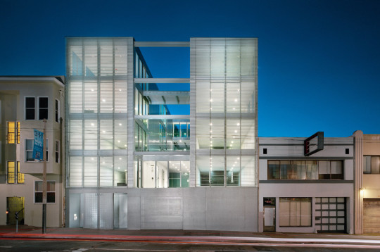
    One project that I’ve always liked for this reason – as well as the fact that it’s beautifully designed – is 1234 Howard Street in San Francisco. It looks like this from above:

    image

    The site is 50′ x 165′ and it spans an entire block. 

    In order to get lots of light into all of the units, the architects (Stanley Saitowitz | Natoma Architects) split the site up into 3 “bars”, each of which would be somewhere around 16′ x 165′. The middle “bar” was then dedicated to a courtyard that cuts through the entire building.

    image

    The two flanking bars were then further subdivided into 2 units per bar, which translates into 4 units per floor x 4 floors. The ground floor is just common areas and parking.

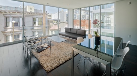
    The advantage of this design strategy is that the apartments now have windows running the length of the courtyard, where as typically on narrow deep lots you would end up with “bowling alley” units and windows just on one end.

    The disadvantage of this design strategy is that you’re now just over 16′ away from seeing what your neighbor is eating for dinner, among other things. 

    But with the right window coverings, I’m sure we’d all survive in these apartments with their Bulthaup kitchens and Miele appliances.

    image

    I love seeing creative solutions to tight urban sites. And one of the things that I worry about, with things like the Mid-Rise Performance Standards here in Toronto, is that we’re reducing or even eliminating the possibility for these kinds of creative solutions.

    I recognize that 1234 Howard is not the same as an avenue mid-rise site in Toronto with low-rise residential behind it. But the thought still crossed my mind as I was writing this piece.

    All photos via Stanley Saitowitz | Natoma Architects Inc.