Daily insights for city builders, delivered every morning at 6 AM ET. I’m Brandon Donnelly — a Toronto-based real estate developer and founder of Globizen. I’ve been writing here since 2013.
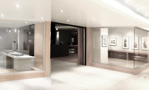
This Tuesday evening at 630pm, WORKSHOP – which is a design studio, gallery, and retail shop located in Yorkville, Toronto – will be hosting a panel discussion titled: What is Smart Now?
On the panel will be a building scientist, a computer scientist, and two architects. The moderator will be Larry Wayne Richards, who is Creative Director of WORKSHOP and the former dean of the Faculty of Architecture, Landscape, and Design at the University of Toronto. He was dean when I was completing my undergraduate degree and is one of my favorite people in the world of Toronto architecture.
Here’s a bit more on the panel:
For more than half a century, visionaries and companies such as Monsanto, Hewlett-Packard, Microsoft, and Samsung have promoted the concept of technologically smart homes with highly integrated, interactive systems. However few of these homes have actually been realized, leaving us to wonder why.
Meanwhile, architects, builders, and home owners have become aware of the advantages of being smart in terms of energy efficiency and sustainability, from using common sense to selectively employing high-tech.
But now, with the digital realm and software advancing rapidly, will sophisticated smart home systems merge with recent advances in high performance materials and energy-efficient construction, making “totally smart” (and affordable) homes commonplace? Will we finally be living in the magical future that was imagined 50 years ago? And what are the implications for architects and architectural education?
And here are the panelists:
PAUL DOWSETT, Architect and Founding Principal, Sustainable TO
SRINIVASAN KESHAV, Professor of Computer Science, University of Waterloo
TED KESIK, Professor of Building Science, University of Toronto
JANNA LEVITT, Founding Partner, LGA Architects, Toronto
LARRY WAYNE RICHARDS (Moderator), Creative Director, WORKSHOP
Given the current “Internet of Things” trend and the fact that software is creeping into so many non-tech fields, such as housing, I think this is a really timely discussion to be having. I also think it’s critical for these kinds of conversations to be cross-disciplinary. There are infinite opportunities in the housing market for people who are able to think in that way.
If you’d like to attend, click here to sign up. It’s free and open to the public. WORKSHOP is located in the lower concourse level of 80 Bloor Street West.
Two weeks ago I gave a brief presentation at The Laneway Project’s inaugural summit here in Toronto. I then wrote about it here on ATC.
At the time, I wasn’t sure if the event was being filmed or not, but it turns out it was. So here is my presentation from the event. It’s just over 7 minutes. Click here if you can’t see it below.
If you’d like to see the other 5 presentations and the Q&A session, click here.
Following the event, I was also interviewed by a radio show out of Calgary called Space + Place. If you are really into laneways and would like to listen to that as well, go here.
I’ve said this before, but I’ll say it again: I continue to be amazed by how much interest there is — both here in Toronto and elsewhere — in laneways. They may be overlooked today, but that’s going to change. It’s inevitable.
A lot of that has to do with how design and technology seem to permeate the culture. But it also has to do with how dichotomous the culture feels to me. On the one hand they’re at the forefront of design and technology, and on the other hand they are very much steeped in tradition. It has always felt like a unique and special place to me.
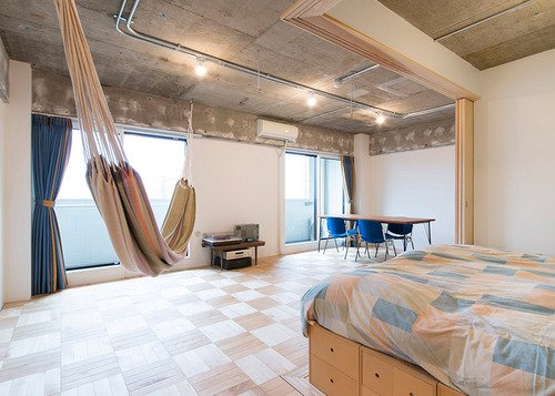
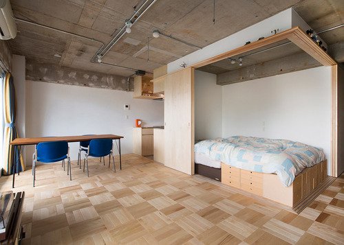
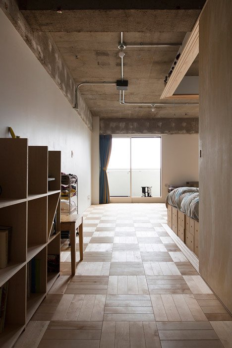
So today on ATC I thought I would share a piece of Japanese architecture that I found on Dezeen. It’s a 47.55 square meter (512 square foot) apartment in Tokyo that was recently renovated by Yuichi Yoshida & Associates.
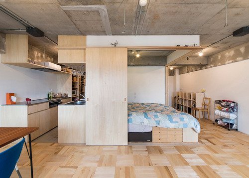
Here are three views of the main living area:
Here’s the view from the main entrance:
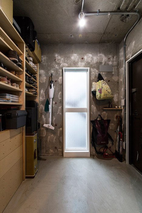
Here’s the walk-in-closet/storage area (notice how the exposed concrete walls have been dabbed with plaster):
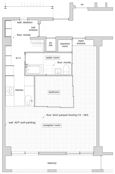
And here’s the floor plan (I’m guessing sub entrance means secondary entrance):
The first thing that struck me was the lack of a traditional bedroom. It’s basically a nook with a bed and sliding doors. But that was obviously done to give more space to the remainder of the apartment and the main living area, which they label as the “reception area.” The idea was that this space could be used for both living and working, and so they wanted a large open space.
The other thing that stood out for me was the amount of storage and shelving throughout the apartment. There’s a bookshelf as you walk in. There are drawers under the bed. There’s a walk-in-closet with floor to ceiling shelving. And if you look closely at the upper track for the sliding bedroom doors, you’ll see a small ledge that was purposefully created for storage and display.
It all seems very Japanese to me.
It’s a small space and yet there’s no absolutely zero clutter. I love how organized everything seems. For many of you, this space may be a bit too sparse (even with that hammock!). But there’s something really nice about the simplicity of it all. It’s peaceful.
Yesterday evening I went to the Toronto Christmas Market in the Distillery District. I had actually never been before, but it was something that I had been meaning to check out for a few years now. And it was wonderful. If you’ve never been, I would highly recommend you go. This past weekend was the opening weekend and it runs all throughout Advent until Sunday, December 21st.
For those of who might not be aware, the Christmas Market festivity is a longstanding tradition that originated primarily in German-speaking Europe. Accounts of a “December market” were found as early as the end of the 13th century. The Toronto Christmas Market is a slightly more recent tradition (it’s only about 5 years old), but it was already selected as one of the world’s best.
But Christmas carollers and hot toddies aside, the Market is also a fantastic opportunity to see the Distillery District in all its glory. Every time I visit the Distillery, I can’t help but feel how lucky we are to have a district like this in the city. The architecture and scale of the place is incredible and – alongside the Toronto Islands and Kensington Market, sometimes – it’s pretty much the only car free zone we have.
However as someone who lived near the Distillery District in its early days, I remember how much of an “island” it was when it first opened. It felt disconnected from the rest of the city and the only way to get people there was to hold a special event. The retailers and galleries struggled and many didn’t last.
With all the condos that have been built, literally on top of the neighborhood, that has changed dramatically. Today the area has become much more balanced as a mixed-use community. But the real tipping point, I think, will come next year when Toronto hosts the Pan Am Games and the West Don Lands neighborhood starts to come online just to the east of Cherry Street.
Now all of a sudden the Distillery District won’t feel like the edge of downtown anymore, it will feel more like the middle of it. As my friend Alex Bozikovic of the Globe and Mail pointed out to me this weekend, the Pan Am Games are going to put the east side of downtown on people’s radars. And I would completely agree. Once that happens, the Distillery District will finally start to reach its maximum potential.
In anticipation of a (very short) presentation that I will be giving at this week’s inaugural laneway summit here in Toronto, I thought that I would share the details about about own laneway house proposal and what I’ve learned from the process. Specifically, I’d like to talk about why it’s currently next to impossible to get a laneway house built in Toronto.
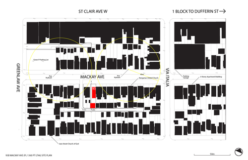
The laneway site I’m talking about is in the St. Clair West and Dufferin area of the city. The neighborhood is officially called Corsa Italia. The address of the site is 95 Mackay Avenue, which is shown in red in the area plan diagram below. The red block to the north is an existing house, and the red – more square – block to the south is the proposed laneway house. Access to the laneway is just to the left of the property.
Right off the bat, there are a few challenges with this property.
First, the laneways dead-end. From an approvals standpoint, you ideally want through-laneways because then service vehicles could, in theory at least, drive right through without having to reverse. But this assumes they can fit in the first place or that the city is willing to allow this.
Second, there’s no existing laneway building at the back of this property. A lot of the laneway houses that you might find in Toronto, such as this one and this one, are renovations of existing buildings. This makes approvals a lot easier because the city isn’t granting a new house, they’re simply allowing an existing structure to be retrofitted. And this is an important distinction because the city is always concerned about setting a precedence. Once one person gets something approved, everybody else will want the same thing.
A more broad-based challenge is that laneways aren’t considered legitimate streets. Most don’t have street names and so your new house won’t be able to receive a proper address. That’s why the city will consider your proposed laneway structure a “house behind a house”. The laneway isn’t considered frontage and so you’re proposing to build at the back. But this is simply a result of how we have historically thought of laneways. There’s no reason they too can’t be legitimate streets.
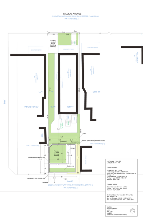
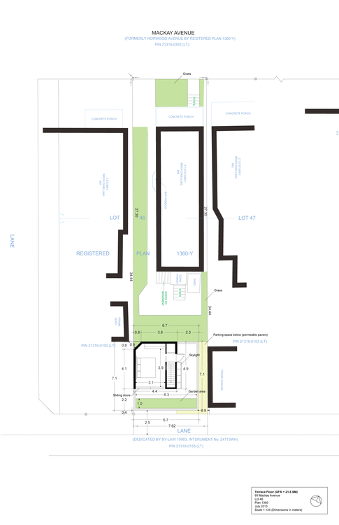
To get around some of these obstacles, I proposed the following 2 ½ storey laneway house:
The strategy was to sever the rear laneway lot in the shape of an “L” so that the laneway house would technically still have frontage onto the main and only nearby street – Mackay Avenue. The top portion of the “L” would run adjacent to the west side of the existing house.
The hope was that I could then get a proper municipal address and that I could potentially run services (water, sanitary, and so on) directly through to Mackay Avenue as opposed to running them around and through the laneway. Servicing is always a huge obstacle when it comes to laneway houses.
However, one of the big challenges with this approach is that it messes up parking. The zoning by-law requires that every house have a minimum of 1 parking spot. When I did this, it technically left the existing house with none. Parking requirements also need to be met on your own property. But there’s no reason I couldn’t seek a parking variance for this.
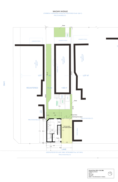
As for the laneway house itself, the plan was to have a surface parking spot (with permeable pavers) adjacent to the ground floor (see below). Since this left a smaller footprint for the ground floor, I decided to put the first bedroom there.
Note: The reason for the chamfered corner on the north west corner of the building is because of a neighboring shed and required separation distances.
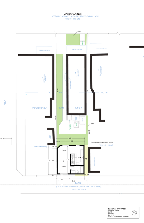
On the second and main floor is the primary living area, as well as the kitchen and the second bathroom. This second bathroom (the first one is an ensuite on the ground floor) would also serve the terrace level bedroom.
Finally, on the terrace level I placed the second bedroom, a green roof/garden, and a skylight that would allow light down and into the main floor living area. I wanted to keep the footprint of this level as compact as possible so as to not create “overlook” issues with the surrounding backyards. The idea was also that the garden and landscape areas could serve as a privacy buffer.
I’ve been working on this laneway house for a few years now and have been in front of city staff, the area planner, and even the local councillor a few times. In a lot of cases, they couldn’t get their heads around what I was proposing. They didn’t know how it could possibly work and they didn’t know why anyone would want to live there (I would totally live there).
I also spoke to a number of the neighbors and many were entirely supportive. Many gave me formal letters of support and one neighbor told me that he would want to do the same on his property if this one were to get approved (that’s why the city gets scared of precedences).
But to take this proposal to the Committee of Adjustment, which would be the next step, it would cost me about $10,000. And there would be no guarantee that it would even get approved at this stage. I might need to also go to the Ontario Municipal Board at the province, which would be another set of costs.
So instead of rushing to do that, I want to iron out as many of the details as I can ahead of time. The proposal you see here is already the result of a few iterations, so I’d rather continue doing that until there’s a bit more certainty with respect to approvals. But I’m not going to give up. I think laneway housing is inevitable in Toronto. Don’t be surprised if you see me launch a Kickstarter campaign sometime in the future.
If you have any questions about this proposal, feel free to leave a comment below.
There are a lot of great architecture firms in Toronto, but one that I’ve been following for years is Solares Architecture. Founded by a husband and wife – Tom Knezic and Christine Lolley – the firm focuses on “environmentally integrated homes”, which is simply their title for incredibly sustainable and efficient homes.
I discovered the firm a few years ago when I was trying to get my laneway house off the ground, and they were unbelievably helpful. That laneway house is still a work in progress (more on that in the coming week), but I’ve followed the firm ever since. They have an awesome blog where they have meticulously profiled the renovation of their own environmentally integrated home. Their new home was also recently featured in the Globe and Mail.
As more and more people wake up to the importance of sustainability, I think that firms such as Solares Architecture are going to become even more important. This is not just about a LEED rating, it’s about a mission. And I think that’s also great for the profession of architecture because it expresses a clear value proposition: this is not just about stye (though that’s important); this is about measurable performance.
Poll: How much do you think this home is or will be worth? Respond in the comment section below. I’ll be giving away one free ATC t-shirt. (Comments)
A few weeks ago a good friend of mine – who is a builder – called me up and told me that I had to come and see a house under construction in Etobicoke (west end of Toronto). He told me that the owner was doing everything from geothermal to a car elevator, and that he was doing it all, not with the intent of ever being able to sell it, but because he just wanted to build something really cool.
I thought: Amazing. I need to see this.
So this past Saturday afternoon, I drove out to 37 Canerouth Drive in Etobicoke to take a look. Situated near Centennial Park, the house is at the end of an unassuming cul-de-sac filled with post-war bungalows that you could probably pickup for anywhere between $800,000 to $1M, fully renovated. This house, on the other hand, has had many multiples of that sunk into it.
But before I get into the house, let me start from the beginning.
The owner actually used to live next door on Canerouth Drive. He lived in a nice, newly renovated bungalow, but he wanted something else. Something cooler. Something he could create from scratch. Being a car collector, one of the driving forces behind a new build was to create a place for all his cars. At one point he had around 7 or 8 of them. So he had decided that it was time to do a knock-down and start again.
But before he could demolish his house, his neighbors – whose bungalow hadn’t been renovated, but which had a slightly bigger and better lot – said to him: “You’ve got to be crazy. Your place is fully renovated.”
Somehow that comment led to the two neighbors actually switching houses. (I think this is fascinating, because I wonder how many of these types of transactions would be possible under the right circumstances.) The neighbors got a newly renovated house, and he got a better lot to build his dream home. It was a huge win for the neighbors, but it also meant one less neighbor to oppose him at the Committee of Adjustment when he went in for his variances.
The biggest variance was apparently density. The house is almost 6,000 square feet. It has somewhere around 4 bedrooms, but also includes a few studio and study areas, a spa area, 2 walk-in closets the size of the bedroom in my condo, and even a “meditation hallway”. The master bedroom and main living areas are all on one floor so that as the couple ages the home remains functional. (There’s also an elevator just in case.)
Being at the end of a cul-de-sac, the lot is pie shaped and the architecture of the house mimics it. The front is concave and the rear is convex – opening up the main living areas and master bedroom to the ravine at the back (see above photo). The owner was absolutely firm in his belief that these curves were central to the architecture. Without them, the house simply wasn’t worth doing, he said.
The initial intent was to build a completely passive solar house, but he found that it was extremely difficult to do so within the confines of our building code. Still, the house contains a significant amount of thermal mass, which is one of the principles of passive solar design. The home uses precast hollow core slabs with 3" of poured concrete on top and in-floor radiant heating and cooling. All of the floors will be polished concrete – love it.
Here’s the main stairwell (check out the support stringers):
Here’s the view from the kitchen looking towards the living room and out to the backyard (the far wall will be outfitted with custom millwork for his pottery collection):
Here’s a shot of the through-fireplace that will connect the living room area to the main stairwell area shown above:
And here’s the meditation hallway:
The most over the top part of the house though, is probably the underground parking garage. This shouldn’t come as a surprise to you given that he’s passionate about cars and it was one of the main reasons he wanted a new house in the first place. At the front of the house (shown in the first image above) is a single car garage, which conceals a parking elevator he sourced from the US.
It looks like this from the basement:
And it leads into this below grade parking area:
There’s enough room for all of his cars and it’ll be fully equipped so that he can work and tinker on them.
But what stood out to me most from my visit – more so than the scale of this project or all the fancy bells and whistles – was his attention to detail and his passion for design. Here is a guy who is worrying about baseboard details and the design of the space down to the centimeter.
Here’s his door detail:
In fact, he gave me a number of examples where a couple of inches here and there were having a profound impact on the experience of the space and he forced the trades to change it. He even spoke about how the 3" concrete floor topping had changed his experience of the outside (for the better). These are subtleties that most people don’t even notice, or care about.
But he sure does.
Of course, in some ways, this is the difference between building for yourself and building strictly for profit. When it’s a passion project, you do things that you love, but that other people will tell you don’t make economic sense. But sometime it’s good to be crazy. I mean, what do those other people know?
So today, I thought we would play a little game on ATC where you try and guess what you think this home will be worth upon completion? Take a guess. There’s no wrong answer here. I’ll also randomly select somebody from the comments to receive a free ATC t-shirt.
I have a rough idea of the costs in my head, but I’d like to see what you come up with on your own first. I’ll also be forwarding this post to the owner, so make sure you respond in the comment section below as opposed to via email or on social media. I’m sure he’d love to see your numbers 🙂
To add one last piece to this story, I discovered midway through our tour that the owner of this house used to be my family’s veterinarian before he retired sometime in the mid 2000s. What a small world. He was an excellent veterinarian (my mom told me to tell him that), but that clearly wasn’t his only passion.
This morning I stumbled upon an interesting documentary (via The Urbanophile) about two New York skyscrapers that were built in the 1930s as telecommunications buildings: the Western Union Building and the AT&T Long Lines Building. It’s fascinating to see how they have evolved along with technological change. Click here if you can’t see the video below. It’s only 8 minutes long.
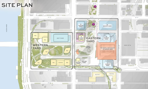
Urban Land Magazine recently published an interesting article on the Hudson Yards project in New York, which is the largest private real estate development project ever undertaken in the United States. Click here for the article. Thanks to my friend Evan Schlecker for passing it along. It’s a good read.
The project is being co-developed by Related out of New York and Oxford Properties out of Toronto, and when it’s all said and done, it’ll be over 17 million square feet of commercial and residential space. It’s a $20 billion development project.
But beyond just being massive and epic, there are a bunch of other things that make this project unique. You can read about them all in Urban Land, but I’d like to share a few snippets with you all here:
The first is about the project’s placement on top of a rail yard:
In order to make use of a site already occupied by a working rail yard—including more than 30 tracks for the Long Island Rail Road and three train tunnels, with a fourth under construction—most of the development will be built atop two steel-and-concrete platforms. That base, and the buildings on it, will be supported by hundreds of concrete-filled caissons, which will be drilled between the rail lines into the bedrock.
Because the location of the tracks and tunnels limits the placement of caissons, only 38 percent of the site can be used to support buildings.
The second is about the project’s use of technology:
Beyond that, a vast number of sensors embedded in the site’s infrastructure will collect mountains of data on everything from temperature and air quality to pedestrian and vehicle traffic. That information, which will be scrutinized in real time by managers in an effort to fine-tune Hudson Yards’ operation, will also be shared with New York University (NYU) researchers, who will turn Hudson Yards into a laboratory for studying urban life and finding ways to improve its quality.
And the last one is about how it interfaces with the High Line (click here if you don’t know what that is):
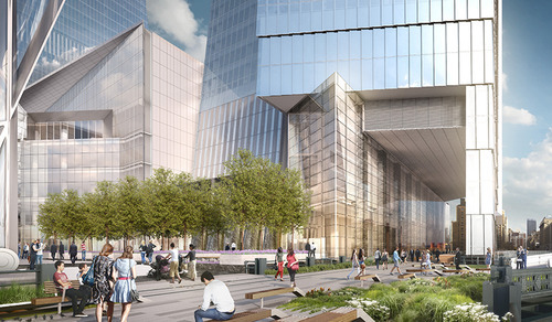
Pedersen [of Kohn Pedersen Fox Associates] found an intriguing way to address the building’s surroundings. He allowed the High Line—a public park built on a historic freight rail line elevated above the West Side—to penetrate underneath the tower through a 60-foot-long (18.3 m) public passageway, so that the building will interact with the park and its visitors. Inside the building, a dramatic atrium “becomes the terminus of the High Line as it moves from south to north,” he says.
So there are a lot of interesting and exciting things going on with this project. What’s amazing though is how “vertical” this community will be. You have rail lines below grade. Platforms on top. Retail at grade and across multiple levels. And an elevated linear park cutting through the buildings. Not every city can make this work. New York can.
I received an email from an ATC reader yesterday who is working on a publication about reimagining public spaces in Toronto. She sent me a few questions and specifically wanted to talk about the Yonge Redux project, which I wrote about a month ago. After I responded to her questions, I figured I should just share them publicly. So here they are:
How would citizens from different age groups benefit from the Yonge Redux project?
I would bet you that this stretch of Yonge Street experiences more pedestrian traffic than it does car traffic. And yet we’ve allocated space in the opposite direction: cars have more space than pedestrians do. So what this project is really about is reallocating the street, or public right-of-way, so that the dominant uses are actually prioritized through urban design. It doesn’t need to be more complicated than that. Ultimately, this will benefit people both young and old.
Do you know what kind of professionals are needed to complete a project like this?
You’d need an architect/designer – one who is awesome at landscape/urban design work. gh3 here in the city comes to mind as a firm I like, if you want an example. You’d need a bunch of engineers to deal with stormwater management and other infrastructure items. You’d likely need a transportation/traffic consultant to assess traffic flows in the area and prove that this project won’t cause the entire city to come to a grinding halt (it won’t). You would need someone to manage the day-to-day of the entire project. And this is just naming a few of the professionals/consultants that you’d probably end up needing.
You’d also have to work closely with the city, the local councillor, and the local community. It’s inevitable that some of the businesses will worry about the loss of potential customers – so that would need to be worked through.
What are some areas in Toronto that, in your opinion, need reimagining in the next few years?
My feeling is that Toronto is still at the early stages of this shift towards better public spaces and a better public realm. But in many ways, projects like Yonge Redux are much easier sells compared to the other areas that could use a face lift. Yonge Street is already urban and pedestrian friendly. The real challenge is going to be dealing with the areas outside of the core – most of which, frankly, aren’t that welcoming to pedestrians and aren’t all that urban. What do we do with those? And do the local communities even want them transformed? They’re going to be much harder to reimagine (though I’m not saying we won’t be able to do it).
Where do you see the future of Toronto’s public spaces in the next 50 years?
All signs point to a more dense, more urban, and more transit-oriented city. With that shift, we’re going to increasingly realize the importance of incredible public spaces. So if we continue down this path, I reckon our public spaces will only get better. I’m optimistic about the future.
How would you personally approach a project like this?
My understanding is that this project has legs. It just has to work through the city bureaucracy at this point. Jennifer Keesmaat supports it.