Daily insights for city builders, delivered every morning at 6 AM ET. I’m Brandon Donnelly — a Toronto-based real estate developer and founder of Globizen. I’ve been writing here since 2013.

Tag: app

  • How many people are actually using a COVID exposure alert app?

    One of the things that I don’t think we are doing a good job of here in Canada is promoting our COVID Alert app. Most of the people I talk to don’t seem to have it installed on their phones. And most of the people I talk to seem to be nervous about sharing personal information with it, including their location. (That’s not actually how the app works.)

    The thing with exposure alert apps is that they’re only really useful if most people are using them. And they’re only really useful if people who test positive for the virus enter the code that they are given into the app. So it relies on us trusting that other people will do the right thing. I get that. But those same shortcomings apply when we just ask someone if they’ve been exposed to anyone with COVID-19.

    I could be wrong, but my view on this is pretty simple.

    If everyone who had COVID-19 got immediately sick and showed highly discernible symptoms, then this virus would likely be a lot easier to control. Part of the problem, as I understand it, is that some people get really sick and some people don’t get sick at all. But these latter people can still unknowingly spread it around — perhaps to other people who might get really sick.

    Given this variability, it’s critical for us to know who has been potentially exposed and who has not been exposed. Otherwise, we’re running around mostly blind. From what I can tell, exposure alert apps are one of the best ways for us to track transmission. But, of course, it only works if you’ve got the app. For those of you who don’t already have it, you can download it for both iOS and Android by going here.

    P.S. I’m writing this post because it came up with my barber today while I was getting a haircut. He wasn’t all that aware of the app, but he ultimately concluded that we have a problem of education and that he was going to download it. Maybe some of you will do the same after reading this.

  • Canada’s COVID Alert app

    I installed and setup Health Canada’s COVID Alert app this morning.

    It’s really simple to do that. You don’t enter any personal information. You just select which province you’re in, agree to let it use your Bluetooth, and give it permission to share the random codes that you collect with its servers (more on this below). The app is then active and working. But to be clear, it doesn’t collect your location (it doesn’t use GPS or location services). It doesn’t collect the places or times that you are next to someone who also has the COVID Alert app. And it doesn’t know if you’re with someone who was previously diagnosed with COVID-19.

    Built on top of the private exposure framework that was collectively developed by Apple and Google, the app works by using Bluetooth to exchange “random codes” between nearby phones that have the app. These are anonymous and random codes that are used to track which phones have been next to which phones for any meaningful period of time. The app also uses Bluetooth signal strength to estimate proximity. So it knows how long your phone has been proximate to someone else’s (with the app) and how close they got to each other.

    That’s pretty much all that happens with the app unless you test positive for COVID-19. At that point, you will be given a one-time key along with your diagnosis. The onus is then on you to anonymously self-report on the app. Once you do that, anyone who was exposed — i.e. next to your phone in the last 14 days — will receive an alert on their phone via the app. And since the app doesn’t know any names or who anybody is, it’s of course all completely anonymous.

    It’s great to see all of this coming together. The private sector worked to build the underlying framework and now you have government building on top of it to deliver public health tools. I know that some or many of you will be concerned about privacy, but that appears to have been very well thought out. If you haven’t already downloaded the app, I would encourage you to check it out. It’s available for iOS and Android and can be downloaded over here.

  • Neural machine translation

    I have been using Google Translate a lot on this trip. Few people here in Rio de Janeiro speak English.

    It is an incredible app that also works without cell service. You just download whatever language(s) you need to your phone.

    There’s a conversation feature that allows you to go back and forth with someone in real time (almost). 

    There’s a camera feature that is invaluable for translating restaurant menus.

    And there are a number of smaller features that I have also found really useful. 

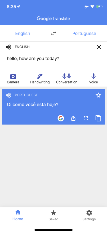
    For example, if you rotate your phone into landscape mode, it will show you your translation in big text like a flash card.

    It looks like this (trust me it is useful):

    imageimage

    I also just learned that, since November 2016, the Translate app has been using a neural machine translation system developed by Google.

    It is capable of understanding and translating complete sentences, and that has reduced translation errors by about 60% compared to the previous system.

    Rather than translate word-by-word or phrase-by-phrase, Google’s NMT network encodes the “semantics of sentences.”

    To learn more about GNMT, click here.

  • What could a connected lockbox mean for the residential real estate business?

    image

    I just discovered an interesting Dallas-based startup this morning called TOOR. They were on Shark Tank and haven’t yet launched their product, but it’s essentially a connected lockbox. Lockboxes are a mainstay of the residential real estate industry (they hold the keys so that co-operating agents can show a property) and they are becoming even more common nowadays because of Airbnb rentals.

    What caught my attention about TOOR is the app that goes along with the lockbox that also allows people to search for homes. Once you’ve found a home you can even find an agent for an escorted tour. I’m not clear on the exact workflow, but I am thinking that if you buy this connected lockbox you then have the opportunity to put your home up for sale on their platform.

    This is interesting because the app will also verify user identities and scan people’s IDs, so it helps to solve the security problem that agents today now solve. I could imagine the app storing my credit card so that if I go into a home unescorted and I do something mischievous, it then charges me. It also makes it really easy to just drive around and pop into homes by instantly scheduling appointments.

    In any event, I may have the exact user flows a bit wrong, but it’s fascinating to think about how something as simple as a connected lockbox could start to chip away at the status quo.

  • A location intelligence company

    I have written about Foursquare a number of times over the years (here and here) and I continue to be a regular user. I am intrigued by all of the location-based data that they collect through their apps. 

    Below is a recent Recode Decode (podcast) with Dennis Crowley (co-founder) and Jeff Glueck (CEO) of Foursquare. They are talking about what’s next for the company. If you can’t see it below, click here.

    https://art19.com/shows/recode-decode/episodes/aa400a60-ebc1-49bb-96b1-0d7aac7ca9e8/embed?theme=black

    Here’s a content sample from Recode:

    Today, Foursquare makes most of its money from selling that data to big companies, calling itself a “location intelligence company.” But as co-founder Dennis Crowley and CEO Jeff Glueck explained on the latest episode of Recode Decode, hosted by Kara Swisher, they haven’t stopped thinking about everyday users.

    “Imagine a friend is walking alongside you,” Crowley said. “Can we make a personality like that, that talks to you in that sense? It’s not 30 years out. We’re going to be playing with this stuff a year from now.”

    “I want to make that Scarlett Johansson that whispers in your ear, but it’s all about local places and local discovery,” he added. “I want to replicate the experience of walking through the city with a friend that knows the city inside and out, and I want to make that for millions of people.”

    I thought some of you might find this interesting.

  • Foursquare uses their global foot traffic data to accurately predict iPhone sales

    I am a fan and long time user of Foursquare – now known as both Foursquare and Swarm.

    Foursquare has struggled against competitors such as Yelp.com when it comes to local business recommendations. And I have less than 100 friends on my Swarm. It doesn’t seem to be that popular here in Toronto.

    But I’ve always loved the data collection aspect of Foursquare / Swarm. Even though most people don’t seem to care about that. When I check-in somewhere, such as the gym, it’ll tell me how many weeks in a row I’ve been there, whether it’s a new personal record, who else is nearby, and a host of other things.

    I’ve always felt like there was so much potential in all of the data it was collecting.

    Well the company is starting to make better use of that data. Recently they used their foot traffic data at Apple stores (I am assuming this goes beyond just check-in data) to predict the number of iPhones that Apple was going to sell globally following the launch of the 6s and 6s Plus.

    They predicted between 13 to 15 million handsets and it turns out they were right:

    This validates the accuracy of our prediction and while we’re proud of the result, we certainly aren’t surprised. Foursquare’s data is essentially the world’s biggest panel of foot traffic data — we have the best sense of the trends and patterns of the movement of people and their phones around the world.

    This is powerful stuff. If there were a way for me to be bullish on Foursquare beyond just writing this post, I would be.

  • Urban Engines launches app

    [youtube https://www.youtube.com/watch?v=FZ8ODREybcs?rel=0]

    About 9 months ago I wrote about a new startup called Urban Engines that was trying to improve urban mobility by using big data to optimize transit usage. 

    Last Tuesday the app launched in 10 cities across North America. So if you’re in Boston, Chicago, Los Angeles, New York, Portland, Seattle, San Francisco, Toronto, Vancouver, or Washington D.C., you can go ahead and download it right now.

    The biggest “wow factor” is probably the augmented reality feature that allows you to hold your phone up and see transit information overlaid on top of the street in front of you.

    But more fundamentally, the real potential lies in the platform’s ability to collect data on the way people move in cities and on how transit lines are performing, so that it can be fed back to improve overall efficiency.

    That’s why the company is also working with cities to give them 24/7 analytics and reporting on how every bus, car, and train is performing in their networks.

    My hope is that with better data at our disposal, we’ll be able to elevate the discussions around transit and transit planning. Without great data, it’s too easy for these discussion to become political.

  • How I moved over the last 3 weeks

    At the beginning of this year I wrote a post about a mobile tracking app called Moves that I had heard about through my friend Sachin Monga. He had just published a beautiful set maps showing where he physically spent his time in both Toronto and San Francisco.

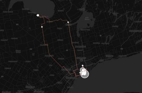
    His post spurred me to download the app and at the end of my post I promised to share my own set of maps once I had collected enough data points. It’s only been about 3 weeks, but already my maps are starting to fill out, so I thought I would do a release.

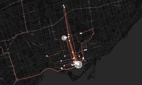
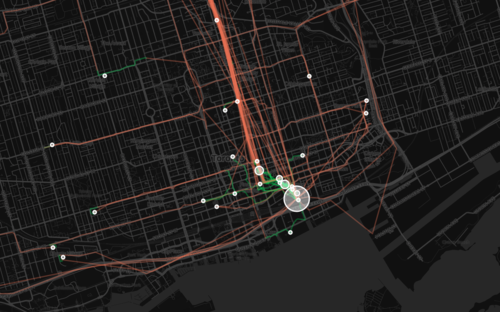
    The orange lines represent transport of some sort (car, subway, streetcar, and so on) and the green lines represent walking. I don’t cycle very often in the winter (I know, I’m a fair-weather cyclist), so you won’t see any of those lines just yet. However if I posted a map from the summer, I know it would look completely different.

    Here’s a first one showing a regional scale:

    image

    Here’s a second one showing the city of Toronto:

    image

    And here’s a third one showing mostly downtown:

    image

    What’s interesting about these maps is how much you can tell about me and the way I move around the city.

    For one, there’s a good chance I ski or snowboard given that I’m driving up to Collingwood, Ontario in the winter. You can also see how heavily dependent I am on the Yonge subway line, which is the thickest orange line in the middle of downtown. It’s also interesting to see how localized I am within my neighborhood (St. Lawrence Market). I walk to get groceries. I walk to the gym. I walk to coffee. And the list goes on.

    This is fairly typical for people living in urban neighborhoods, but it would be interesting to see where it applies in the city and where it begins to fall apart. I would also imagine that there’s a correlation to the area’s Walk Score, although this (Moves) might actually be a better measure since it’s usage data.

    Either way, imagine what cities could do if they had this sort of data for every resident. They would be able to see precise resident flows and then determine exactly where transit and infrastructure investments should be made instead of politicking to determine where they should be made.

    That time is coming.