Daily insights for city builders, delivered every morning at 6 AM ET. I’m Brandon Donnelly — a Toronto-based real estate developer and founder of Globizen. I’ve been writing here since 2013.

Tag: aerial photography

  • Coastline villages

    I recently collected two NFTs from aerial photographer Vitor Esteves. I purchased one of Menton, France and one of Las Negras, Spain (pictured above). Both are from his 1/1 Coastline Villages collection on Sloika. I know that NFTs aren’t nearly as popular as they were last year, but that is exactly why now is a great time to be collecting. Talented artists continue to create, but ETH gas fees have come way down (a few dollars versus sometimes over a hundred at the peak) and there is now far less competition out there. It is no different than trying to buy great real estate when the rest of the market is sleeping.

    At some point, I’m going to need to pull the trigger on a good NFT display. I’ve been contemplating a Tokenframe, but I also think that most TVs are going to appropriate this function pretty soon. Some already have.
  • Toronto: 2000 vs. 2025

    Last week, Joe Berridge, Partner at Urban Strategies, gave a presentation at the Institute on Municipal Finance & Governance titled, Toronto: The Accidental Metropolis. I’ve seen Joe give similar presentations to this one before, and I always thoroughly enjoy his focus on Toronto’s position as a global city.

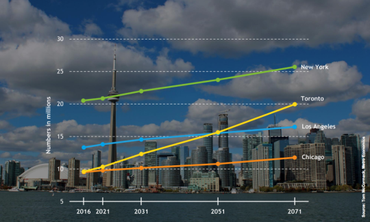
    Here is a slide from the presentation that projects out Toronto’s population to 2071 and compares it to the largest cities in the US.

    image

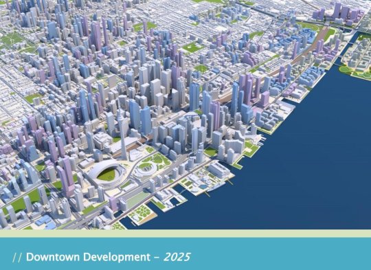
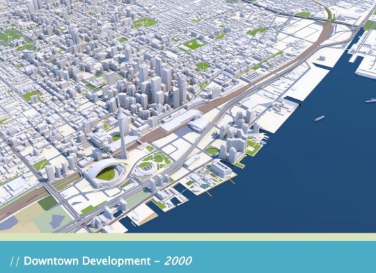
    But the two slides that have been really making the rounds online are the following ones. The first is a rendering of what downtown Toronto looked like in 2000. 

    image

    I remember this time clearly. Queen West seemed to end at Spadina. King West and Ossington weren’t things. And “Richmond and Adelaide” felt like the greatest club district in the world. (If you’re not from Toronto, these references will likely mean nothing to you. Sorry.)

    The second slide is a rendering of what Toronto will look like in 2025. The transformation is just incredible.

    image

    I’ve seen some people comment that the Toronto of 2000 was relatively affordable; the Toronto of 2018 is unaffordable; and the Toronto of 2025 will be even more unaffordable with all of this new development.

    But I don’t understand that logic. Considering the growth rate shown in the first slide, imagine how unaffordable this city would be if we weren’t building new places for people to live and new places for people to work.

    For the full slide deck, go here. And for recent aerial photos of Toronto’s downtown core, check out my Instagram page.

  • DroneBase — real estate aerials

    image

    Real estate companies often have a need for aerial photography. Perhaps you want to showcase an existing building. Perhaps you want to capture the views from a future/proposed building. Or perhaps you’d like to document a building under construction.

    Usually in the latter case, you have to find a neighboring building and negotiate some sort of agreement so that you can place a camera on it and document your construction site. This is probably still the solution if you want a clean time lapse video.

    But drones have opened up a new world of possibility and today I thought I would share with you a company called DroneBase. They’ll probably hate that I’m making this reference, but one way to describe them is Uber for drones. They connect a “large network of drone pilots” to customers needing drone footage for commercial or creative purposes.

    If you take a look at their website, you’ll see that they cater a lot to the real estate and construction industries. I’m not sure how active they are in Toronto and Canada right now, but if they aren’t that active I’m sure it’s only a matter of time before they are. 

    And over time, I am sure that a network like this will only mean faster, better, and more affordable aerial footage.

  • Taking a picture of the world, every day

    This morning I finished watching the rest of Steve Jurvetson’s Spark 2014 talk, which I shared with you all yesterday. And so I’ve got technology on the brain right now.

    I’ve said this many times before on ATC, but I truly believe that the pace in which technology is infiltrating “non-technology” companies is only going to increase. The video clip of Flux.io is a perfect example of that. After watching that demo yesterday, I immediately thought a handful of consultants that real estate developers use on projects that the Flux platform could replace.

    image

    So today I thought I would share another company that Steve talks about in yesterday’s video called Planet Labs. Planet Labs’ mission to image the entire world and make it universally accessible to people. But unlike Google and Microsoft – who already offer satellite photography – Planet Labs has figured out a cost effective way to do it on a daily basis.

    Because the problem with services like Google Maps and Bing is that they’re updated too infrequently. If I go to Google Maps right now, the building I live in doesn’t even exist in their aerial photography of Toronto – it’s still a parking lot. So there are limits to what you can do with this information.

    But once you increase the image frequency to daily, you create all sorts of new opportunities. You could track the number of cars in every parking lot in the world to measure retail activity (an example Steve gives in his talk). You could track changing water levels. You could track deforestation. You could track urbanization in China. And the list goes on. Here’s a blog post from Planet Labs that gives a few examples of the benefits of daily imaging.

    To return to my earlier point, consider the fact that every potential use case I’ve just outlined is in an industry that most of you wouldn’t consider to be tech. And yet Planet Labs is clearly a technology company. So the key insight here is really to focus less on the way things are done and classified today, and more on the way they could be – and likely will be – done in the future.

    Image: Planet Labs