Daily insights for city builders, delivered every morning at 6 AM ET. I’m Brandon Donnelly — a Toronto-based real estate developer and founder of Globizen. I’ve been writing here since 2013.
Today, more than 125,000 health-care professionals use Figure 1 to view or share free medical imagery, including photos of patients with personally identifiable details blurred out or excluded; x-rays; charts; and still images taken from MRI or CAT scans, for example.
The app’s users include board-certified doctors, registered nurses, medical and nursing students, physicians’ assistants, and others who use the app and share images for teaching and studying purposes, or even to request community feedback about a possible diagnosis.
With this round, USV is now up to 3 investments in the Toronto/Waterloo region (I think of us as one center). The other 2 are Kik (out of Waterloo) and Wattpad, which is actually headquartered here in the St. Lawrence Market.
What’s exciting to me about all of this is that it’s further evidence of a growing and thriving Toronto/Waterloo startup ecosystem. And while to some it may not seem like a big deal for yet another mobile app to receive funding, it’s actually great news.
Because as these companies grow and become successful, they’ll not only create new jobs in the region, but also create a tremendous amount of wealth and expertise. And when this wealth and expertise gets reinvested into future startups, you end up with a powerful snowball effect. That’s how startup ecosystems are built.
It’s also great to see companies staying put, because the pull towards more established startup hubs can be significant. When my friend Evgeny raised a Series A round from Andreessen Horowitz last year, he told me that they asked him to move 500px down to California. As is the case with a lot of VCs, they like their portfolio companies to be nearby.
But ultimately 500px decided to stay headquartered here in downtown Toronto. And they did that for a few reasons: There’s lots of great engineering talent here and it usually comes at a discount relative to California (5-15%). He also finds that employees here are more loyal. There’s less turnover. In California, everyone is looking for that next best startup to join. Here 500px gets to be that big fish in a small pond.
Anyways, a big congratulations to the Figure1 team. I hope they continue crushing it and that they stay put in Toronto. If you’re a healthcare professional, you can click here to download the app.
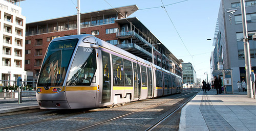
Last weekend a friend of mine sent me an article from The Economist talking about why trams, streetcars, and light rail are a waste of money. The argument is basically that steetcars are expensive, less efficient, and that – despite North America’s renewed interest in them – we should instead be spending our scarce public dollars on more buses.
…but cash spent on streetcars displaces spending on other, more cost-effective forms of public transport like buses, which offer cheaper and more-efficient service but are considerably less sexy. The capital cost per mile of a streetcar is between $30m and $75m, while a rapid bus service costs anywhere between $3m and $30m, according to the American Public Transportation Association.
Now, there’s no question that buse routes are initially cheaper to implement. You don’t have track to build. But I don’t agree that the cost structure is quite that simple if you consider the number of people you need to move in your city. I struggle to see buses as a more efficient service.
The big difference between modern light rail and buses is capacity. Toronto’s new streetcars will move about 3 times as many people as your typical bus. So you’d need to triple the number of buses and triple the number of drivers – adding to your labor costs – if you want to have a chance at moving the same number of people.
Streetcars are also electric, which means they run on a renewable energy source. We’re in the process of making this switch with private transport, so why go backwards when it comes to public transport? You can certainly run electric buses as well, but then you’re building overhead power lines and bringing up your initial costs.
I think the challenge is that when people think of light rail, they think of slow lumbering streetcars. I agree that many of these lines are inefficient and I’ve written about it. But there are a number of ways to implement light rail. And when done well it can efficiently move a lot of people for costs that are far less than a subway.
When I was working on my startup Dirt last year, one of the things we spent a bit of time figuring out was how to classify buildings according to neighborhood. Now, at first blush, this may seem like a fairly easy thing to do. You simply locate the building, figure out which neighborhood it’s in, and then tag it accordingly. But neighborhood boundaries and definitions aren’t as clear cut as you might think.
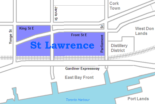
For example, a lot of you probably know that I live in the St. Lawrence Market neighborhood of Toronto. And indeed, if you look at this Wikipedia definition, I live in that area. But if you look at what they call it, it’s just: “St. Lawrence.” They also specify that it used to be called “St. Lawrence Ward”, but that today most people actually call it “the St. Lawrence Market.” So here you have an example of an evolving and changing name.
But then there’s the question of boundaries. According to Wikipedia’s definition, the north boundary is Front Street. This means that the North Market Building would be technically outside of the area and so would the Market Square condos. But I suspect that almost everyone would consider these two buildings to be part of the neighborhood. So where exactly is the north boundary? Is it King Street? Or maybe by Front Street they mean that all buildings on the north side of the street are included.
If you look at the city’s official neighborhood list (which is built from Statistics Canada Census Tracts) you’ll find a completely different boundary and name. According to this list, I live in the “Waterfront Communities–The Island” neighborhood. Obviously nobody, other than maybe somebody who deals with census data, would have any idea what this area is. But it’s how the city tracks its demographic data.
What this begins to show you is that neighborhood definitions and boundaries aren’t as black and white as they might initially seem. And it’s partially because cities themselves are always in flux. New neighborhoods emerge and old ones reinvent themselves. And as that happens, people start introducing new names and new terminologies.
When I was about 19 years old, people in Toronto used to say they were going out “on Richmond and Adelaide.” Since then, gentrification has pushed many of the bars and clubs out of that area. So people instead go out “on King West” or “on Ossington.” And as people begin to use those terms and identify with an area, new brands are created. Ask anybody who lives downtown and I bet they’ll tell you that King West has its own unique personality and even a type of person who typically lives there. This is an on the ground type of awareness though, which doesn’t get captured in census tracts.
The other reason neighborhood boundaries can be so fuzzy is because we – the real estate community – are constantly trying to manipulate them for our own benefit. I’m indifferent to the fact that this happens, but it is a reality. Think about how much the neighborhood of Yorkville has been stretched from its original roots north of Bloor Street. If a neighborhood has a good brand, agents and developers will naturally try and leverage it. Homeowners do it all the time too. Would you prefer to say that you live in Seaton Village or the Annex?
Ultimately, we (my Dirt cofounder and I) decided that neighborhood definitions and boundaries needed to be fluid. They needed to dynamically adjust with the market and come from as many people as possible on the ground. Because at the end of the day if the official documents say one thing, but the majority of city residents believe another, then that official boundary and definition are probably out of date. The crowd wins here.
We liked this approach because it was organic – just like cities.
As a recent graduate of Rotman’s Morning MBA program (and presumably because somebody over there reads Architect This City), I was asked to write a guest post for their MBA blog. More specifically, I was asked to share my thoughts on the real estate industry and on my time at Rotman. And since I haven’t really done a post like this before, I thought it would be worthwhile to do.
But before I begin, I think it’s important to explain a bit about my background and my motivations for doing an MBA in the first place. Before going to Rotman, my first master’s degree was in architecture and real estate from the University of Pennsylvania. Basically it was a Master of Architecture combined with their MBA real estate concentration. So it included everything from real estate finance to real estate development.
Having already done this 3-year program, there were a couple of things I wanted out of an MBA program. First of all, I wasn’t prepared to go full-time. Five years out of the workforce was simply too high of an opportunity cost for me and so part-time was all I considered. I also only applied to Rotman because I didn’t want to waste any time traveling outside of the city (or to other parts of the city). I also saw Rotman as a rising star and one of, if not the, best option in Canada.
At the same time, I didn’t give much thought to the real estate curriculum being offered even though I fully planned to stay working in the real estate industry. I felt like I already had that sort of formal training and so, unlike some of my classmates who were looking to switch into real estate, I was after something else. I ended up majoring in Innovation & Entrepreneurship.
What I was trying to do was really round out my skillset and fill in some of the missing holes: accounting, marketing, and so on. But even more importantly, I had drunk the kool-aid around Rotman’s focus on integrative thinking (renamed “business problem solving”) and “design thinking”. And since there will always be a part of me that thinks of itself as a designer, it seemed like the perfect program for me.
Because at the end of the day, it’s not that hard to learn how to create a real estate development pro forma or calculate your expected exit cap rate on some piece of real estate. That stuff is all fairly mechanical. It might seem quite mythical when you don’t know how to do it, but once you do, you quickly realize that a financial model is only as good as the assumptions you put in. As we’re told in school, garbage in = garbage out.
The real value gets created in the assumptions. It’s created in the way you think about the market, your product, and your customers. And a lot of the time, the most value is created when you know or believe something that nobody else believes to be true. If you’re a lemming, you’re going to get lemming like returns and outcomes. So in a lot of ways, I went to Rotman to help me think better and think differently.
In some industries, resting on your laurels can kill you in a relatively short period of time. See Blackberry. Real estate, on the other hand, is generally a bit slower moving. But that doesn’t mean that change doesn’t happen and that there isn’t room for loads of innovation.
Just look at the Toronto of today versus the Toronto of 10-15 years ago. We’ve transformed ourselves into a city of high-rises where more and more people now want to live in the core of the city. This has brought commercial landlords back to the city center so that employers have downtown office space to attract the best human capital (see South Core) and it’s brought suburban retailers into the core to sell to these same urbanites. We’re seeing a complete reversal of the trends experienced with the last generation.
Amidst all of this, I’ve been noticing a growing awareness and passion around cities. My blog Architect This City started as a forum for architects, planners, and developers, but it has grown into a community of thousands of people who simply love cities. They’re passionate about everything from architecture to grade-separated bike lanes (as geeky as that probably sounds).
So I think that it’s not only the real estate market that’s changing, but also the professions involved with it. I’ve written a lot about the future of the architecture profession because I think we’re starting to see the emergence of new business models. Architects are becoming developers and developers are starting to become much more heavily involved in the shaping of the communities in which they build. Which is why in many ways, I think of my self as a city builder more than anything else.
Finally, to make matters even more complicated, technology is starting to have a huge impact on the business. Zillow.com just bought Trulia.com for $3.5 billion to form a portal that will now serve around ¼ of the online US residential market. And Opendoor.com is getting ready to launch a product that seems entirely poised to disrupt the way homes are bought and sold in America.
So what I’m getting at is that there’s absolutely no guarantee that the way we used to do something, is the way we’re going to continue doing it. In fact, I operate under the assumption that everything can and will be changed by somebody at some point. And if this is the way you approach things, then it should become abundantly clear to you that being able think critically is going to be one of your most important assets.
When I was just starting at Rotman, I met for lunch with an upper year classmate who told me that one of the best things he’s taken away from the program is the ability to think about the way he thinks. That may sound silly to some, but in our uncertain world, it’s actually a great skill to have.
Earlier this week my good friend Gabriel Fain emailed me a bunch of photos from his recent trip to Melbourne. Gabriel and I went to architecture school together here in Toronto and we often go back and forth on city building issues.
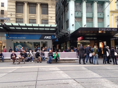
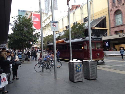
Here are the photos he sent me of Bourke Street in Melbourne:
The comparison he drew in his email was to that of Bloor Street in Toronto, except with a few major differences: Bourke Street is pedestrian only (except for a tram running down the middle of it). It has no curbs. There’s lots of inviting seating. And the connecting cross street laneways are fully activated. He then ended by saying that "Toronto is light years behind Melbourne and Sydney in the terms of the quality of the public space.“
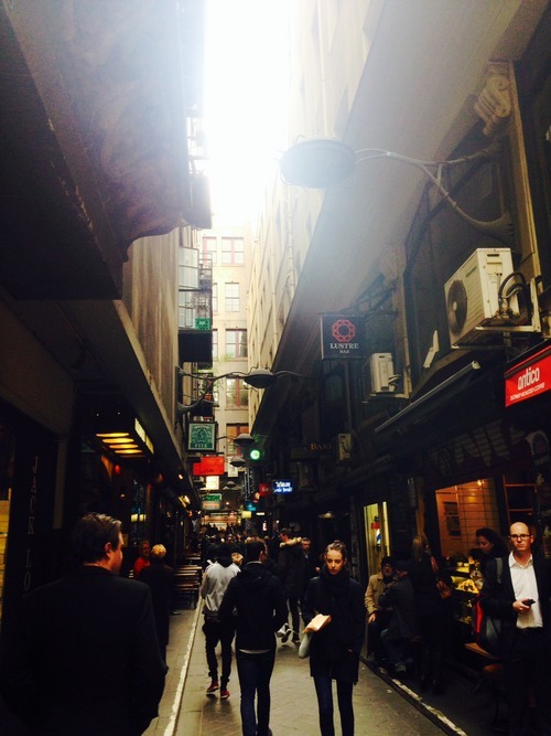
I replied and asked if I could turn his email into an ATC post. He responded by saying that he was hoping I would, and then sent me another photo – this time of one of the laneways:
Melbourne’s laneways and arcades are celebrated around the world. What was once just residual space, became a catalyst for the revitalization of the city’s central business district in the 1990s and a major tourist destination. But all it really took was a change in thinking. It took somebody to believe that the space used for garbage collection, could also be used for a thriving culture of intimate al fresco dining.
In Toronto, I think we’re headed in the right direction in terms of our thinking, but that we’re not yet being bold enough. The recent revitalization of Market Street in my neighborhood (St. Lawrence) is a wonderful example of putting pedestrians first and a wonderful street overall. Like Bourke Street, it also doesn’t have curbs (this is how you know pedestrians matter). But it was also a prime candidate for a pedestrian-only street. Especially given that Market Lane to the north is already one (though in desperate need of renewal).
For a number of reasons though, pedestrian-only streets are difficult to accept here in Toronto. I’ve been shot down many times in real estate meetings for arguing that we should have them in our city. Oftentimes people say it’s because of our harsh climate. But in my view, that’s all the more reason to have them. When the weather is nice, we should be enjoying our public spaces to the fullest. Why only build to the worst case scenario? Plus, they work in Scandinavia.
We’ve also done it before. In the early 1970s (when I wasn’t around), a portion of Yonge Street was piloted as a pedestrian-only mall – a remarkably forward-thinking achievement for that era of city building. So I’m confident that it can be done and that we’ll one day do it again.
I’m convinced that city building – like probably every other industry – is going to get a lot more data driven. Yesterday I wrote about how driverless cars are collecting exact replicas of our cities as a result of the 3D scanning that they do. And today I learned about an interesting new startup called Placemeter.
Basically it works like this: If you have a window (at home, at the office, or wherever) that faces onto a lively street, Placemeter will pay you to setup a smartphone in that window as a “meter.” The going rate is up to $50 per month and they’ll even provide you with the necessary suction cups.
Through video, your phone will then start collecting anonymous data about that street’s activity levels: the number of people, cars, and so on. Below is a video of what that output looks like. Notice that it’s even collecting the number of people that go into each of the stores. Click here if you can’t see the video below.
To make money, Placemeter plans to sell (or is already selling) this data. And their goal is to “make your city better” by specifically improving the way that pedestrian spaces are designed. There are of course lots of other use cases for data like this (such as seeing how busy that bar is across town), but their primary goal appears to be around city building. At least that’s the case right now.
Not surprisingly, there are concerns about privacy. But I’m sure they’ll be able to work around that. All of the data they collect is anonymous and they don’t save any of the footage that they receive from the meters. Their system just extracts the relevant data points and then automatically deletes the video.
What’s also interesting to me about this startup, though, is that it’s yet another example of decentralized value creation. Just like Airbnb empowered anyone with a spare room to run their own bed and breakfast and YouTube empowered anyone with some talent (or a funny cat) to create engaging content, Placemeter is allowing anyone with a window and a view to connect and contribute to a network of urban sensors.
And it works because the marginal cost of adding a new meter to their network is relatively low. Especially if you compare it to what it might cost for a municipality to setup and manage a similar – albeit centralized – system. It’s a totally different cost structure. So when we talk about smart cities and data driven city building, we’re really talking about networks and an environment of decentralized inputs.
It’s a pattern that keeps coming up as a result of the internet. If you start watching for it, I’m sure you’ll see it.
Here’s further evidence that technology is starting to infiltrate into many other industries, including architecture. London-based architect and designer Pernilla Ohrstedt is currently working on an exhibition for Dezeen and MINI Frontiers that will architecturally visualize the 3D data that driverless cars collect in order to navigate around.
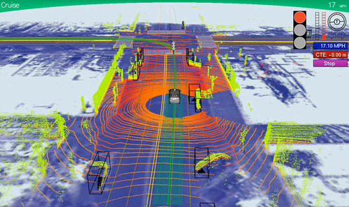
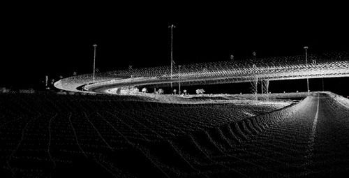
I had never thought of this before, but as a byproduct of driverless cars, we’re about to start collecting detailed replicas of all of our cities – well beyond the static images we currently have with Google Streetview. In order to navigate by themselves, driverless cars are constantly scanning their surroundings to create a “point cloud” replica of the built environment. This point cloud basically tells the car where they are, where they should drive, and what obstacles might be around.
It could look something like this:
Already there are firms like ScanLAB emerging to provide 3D scanning, publishing, and visualization services. But this is obviously just the tip of the iceberg. I can only imagine what innovation will emerge from the passive collection of all this data once driverless cars become commonplace in our cities.
As one example, it could be a way for us to systematically measure the correlation between the qualities of a street and the vibrancy of its street life. Is there a perfect width? An ideal traffic volume? A right scale? All of this data could make city building more of a science (and perhaps less political).
My hope though is that this data would be open and accessible to all, so that clever entrepreneurs could build on top of it.
I’ve just launched a set of city tees over at shopATC. To start, there are 4 cities (Toronto, New York, Vancouver, and London) and each one is available in either black or (ATC) orange. They’re printed on a super soft American Apparel tee and cost only $30 each. I picked the cities based on readership levels. I hope you like them.
I was out for a bike ride last night and, on my way home, I decided to try out the new dedicated bike lane on Adelaide Street. Usually I would take King Street, but it was completely full because of Caribana parties.
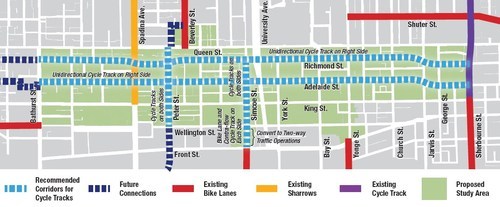
For those of you who may not be aware, the city of Toronto is currently piloting two dedicated bike lanes on Adelaide Street and Richmond Street in the downtown core. Both streets are one-way and because the lanes were so big to begin with (highway-like spacing), I’m told that these new bike lanes didn’t even eat up a driving lane.
Here’s a map of the pilot area:
Given that dedicated bike lanes are a scarce resource here in Toronto, I have to say that it was rather luxurious having my own piece of road. And because there’s no longer any fear of parked car doors swinging open, I was able to ride a lot faster than I normally would.
But as my friend Evgeny pointed out earlier this week, there’s a big difference between dedicated and grade separated bike lanes. Indeed, on my trip from Bathurst Street to Church Street last night, I encountered 3 cars parked in my lane.
So, I hope that these bike lanes become a permanent fixture downtown, but that the city makes them grade-separated. I’m sure people will use them. At the same time, I think they could also act as a catalyst for more pedestrian life along both of these streets.
If you haven’t yet tried them out, I would encourage you to do so. The city is tracking usage and so you would be supporting the cause. And if there’s anybody parked in your lane, below is one way to handle it. It’s a video by Casey Neistat out of New York. If you can’t see it below, click here.
The car had a profound impact on the landscape of our cities (and that’s probably the understatement of the year). Not only did it force the decentralization of our cities (i.e. sprawl), but it dotted the landscape with gas stations and other things that cars required.
According to the Verge, the first gas station was built in 1905 in Missouri. And it was really thought of as a side business for pharmacies and other business owners. But as of 2012, there were 121,466 gas stations throughout the United States. It obviously became a big business.
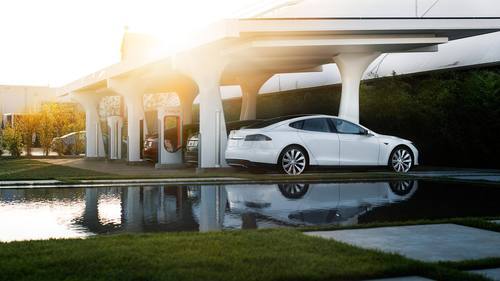
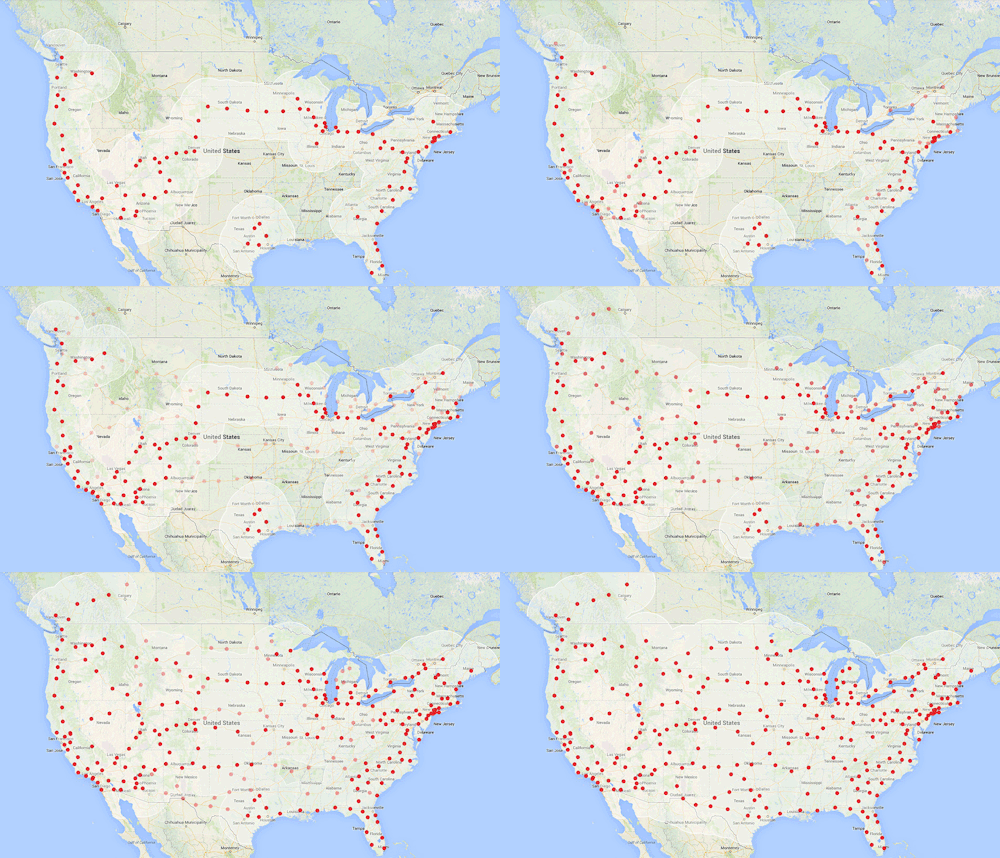
But as we make the transition from gasoline cars to electric ones, we’re going to need a new network of “refill” stations. In fact, this network is probably more important than the cars themselves if the goal is widespread adoption.
But there are two important differences when it comes to comparing Supercharger stations vs. traditional gas stations.
First of all, these won’t be the only places where drivers will be able to recharge. People will also charge their Tesla at home. In fact, I would assume that for regular city driving, most people would do just that. It’s far more convenient to just drive home, plug in your car, and have it recharge while you’re sleeping (just like we already do with our smartphones). And if this is the case, then these Supercharger stations will be primarily used for long drives, which means we probably won’t need as many within our cities.
Secondly, these Supercharger stations are free to Tesla drivers (provided you purchase that option with your car). This is really interesting, because it changes the economics of the industry. Selling gas is no longer a profit center.
But what I wonder – especially now that Tesla has open-sourced its technologies – is how these free Supercharger stations will ultimately fit into the broader electric vehicle market. Will other manufacturers create Tesla Supercharger compatible cars? Or will we see a rival set of charging stations emerge?
My sense is that Tesla is doing what it can to ensure it becomes the standard.