Daily insights for city builders, delivered every morning at 6 AM ET. I’m Brandon Donnelly — a Toronto-based real estate developer and founder of Globizen. I’ve been writing here since 2013.
This change has been in the works for a number of years. And it’s already allowed in most of Europe and in other places in Canada, such as British Columbia. So it’s nice to see this finally happen here in Toronto.
The reason this is a big deal, and worthy of a blog post, is that it changes the cost structure for mid-rise buildings. Simply put, wood frame buildings are cheaper to construct compared to reinforced concrete and other buildings materials.
Some people think this just means developers will make greater returns. But I don’t think that’s the case (see microeconomics). The real opportunity here is to spur mid-rise development on sites that – before this change – would have been previously un-developable. That is, you just couldn’t make the numbers work.
As much as mid-rise buildings make a lot of sense from an urban design standpoint, it’s not always easy to find good mid-rise development sites. Mid-rise buildings are generally less efficient to build compared to towers and you have a lot of fixed costs that don’t scale down just because you’re doing a smaller project.
So what this change in cost structure will, hopefully, do is allow more product to enter the market. And since many big urban centers operate with perpetual supply deficits – precisely because it’s often so hard to build – this should actually help with affordability.
The area that stretches between the property line on one side of a street and the property line on the other side of a street is called a public right-of-way here in Toronto. It may be called something different in other cities and countries.
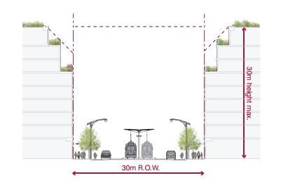
In the example below (taken from Toronto’s Avenues & Mid-Rise Buildings Study), it includes the sidewalks, the car lanes, and the streetcar lanes. But it could also include other public elements. In this instance, the buildings on either side of the street are assumed to be built right up against their property lines.
ROWs obviously serve an important public function. But their size also has important urban design implications. As a pedestrian, it feels different to walk on a narrow street than it does on a broad street.
The width of a ROW can also be used to inform what the preferred height of the buildings along it should be. In the example above, they’re talking about a 1:1 relationship between the width of the ROW and the preferred height of the buildings.
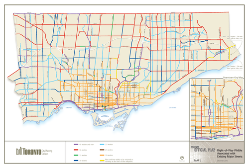
Given their importance, I thought it would be interesting to share this map of Toronto (dated 2010) showing ROW sizing throughout the city. The mustard colored lines in the core of the city represent 20 metres, the red lines 36 metres, and the purple lines 45 metres or more. The rest of the colors fall somewhere in-between. For the most part, the purple lines represent highways, although there are a few other instances of purple.
What’s interesting – but not surprising – to see is how we basically kept expanding the size of our ROWs as Toronto grew outwards. This was obviously to make more room for cars on the road.
But the other, perhaps more interesting thing about this map, is that it could also serve as a guide to pedestrian happiness. The mustard/yellow lines are where it’s most enjoyable to walk. And the red and purple lines are where it’s least enjoyable to walk.
If you’re from Toronto, give this framework a try and see if it holds true.
A few weeks ago I was invited by Toronto realtor Andrew la Fleur to participate in his True Condos podcast series. I had actually never met Andrew before in person, but I knew of him because of Twitter, his blog, and because he was an early user of my past startup, Dirt.
I was initially a bit apprehensive about being on a realtor podcast, because I thought it might end up as some sort of cheesy marketing piece. But I’ve come to learn that Andrew is not that kind of guy. He’s also interviewed some really great people in his podcast series (here’s the full list), so I feel honored to have been invited.
I’ve embedded the podcast below, but if for whatever reason you can’t see it, click here to be redirected to Andrew’s site. We talk for about 30 minutes, with a big focus on openness and transparency in the real estate industry. Thanks again for the invite Andrew. It was great to meet you in person.
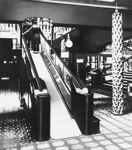
On Wednesday, November 16th, 1898, Harrods department store in London opened up the first escalator – or moving staircase as it was called – in England. The first escalator-like machine in the world had actually been patented many decades before in the US, but this was the first real application in England and likely one of the first in the world.
At the end of the 1800s, this was a big deal. Victorian England had never seen or experienced anything like this before and people were genuinely concerned about its use. More specifically, people worried what such a rapid change in elevation would do to the body. It was believed that it could discombobulate your inner workings. People were unnerved.
Which is why when it was first introduced at Harrods, people were offered brandy and other substances at the top of the escalator in order “to revive them after their ordeal.” Riding an escalator was no small feat for these people.
Now to us today, this sounds ludicrous. Most of us probably ride a few escalators a day. They’re ubiquitous. But I tell this story because I think it clearly underlines how disruptive the new and unknown can feel, and how difficult it can be for us to accept sometimes.
If you go back throughout history, you could easily replace escalators for many other new technologies: the printing press, the automobile, the internet, and so on. And in some cases we were wrong to worry, and in other cases we were right to worry.
Cars, for example, have had a pretty dramatic impact on our lives and the way we build our cities. And since the very beginning, they had no shortage of critics. But does that mean we should have never invented the car? I don’t think so.
As I said earlier this week week, the goal in my mind is to find the right balance between preservation and progress. Just as we shouldn’t be so quick to erase our architectural history, we shouldn’t be so quick to erase our way of life.
But at the same time, it’s important to remain open minded to what’s coming. I’m optimistic about the future. Change can be a great thing, even if it may feel as uncomfortable as riding an escalator for the first time. Maybe you just need a bit of brandy to calm your nerves.
Last month marked the one year anniversary of Architect This City. This means that I’ve been blogging every day for over a year. It’s been an incredible journey and I often tell people that they should give it a try if they have any inclination.
So today, I’d like to share some of the things I’ve learned over the past year. I actually started this post at the end of last month, but I needed some time to collect my thoughts. Now that they’re collected, here are 10 things I learned from blogging every day for a year:
1. Starting from zero sucks
Lots of people have grand ambitions of blogging their way to prosperity. But then they start and they realize it sucks. It’s incredibly difficult to write content on a regular basis when all you get back is crickets. All you’re doing is giving without getting anything in return. But that’s why starting anything from nothing is always difficult.
2. Passion actually means tenacity
When people say that you should follow your passion (you know that cliche), what they’re really getting at is that anything worth doing is going to be a complete and utter slog at times. And the only way to make it through those periods is to actually enjoy the journey enough so that you keep doing it when it’s not so fun.
3. Accomplishment has a lot to do with momentum
As much as starting sucks, once you get going you develop momentum. People start telling you that they read your stuff every day and you get addicted. You realize that you can’t stop. Somebody is actually reading what I’m writing! You also notice that things are starting to snowball. For example, it took me about 11 months to get 250 followers on Tumblr. It then took me another 3 days to break through 2,000. There’s a snowball effect.
4. It gets easier
I follow wine guy and internet marketer Gary Vaynerchuk. I love his energy. And one of the things he’s said about his father’s wine business, that he famously helped grow, is that even though he took it from $3 million in sales to $45 million in sales, he recognizes that the truly hard part was actually going from zero to 3. Starting from nothing is hard.
5. Good things come from putting yourself out there
Often I’ve found that my most popular posts have been the ones that I felt a little uncomfortable posting or that I quickly wrote without seconding guessing myself. Social media and internet marketing today, at least in my view, is all about being authentic, genuine, and as transparent as you or your business can afford to be. Because that’s what engages people.
6. Constraints can be great for creativity
I can be a bit of a perfectionist. It’s the designer in me. In architecture school, my favorite line was: Perfection or nothing. I got it from the German engineering and design firm, Werner Sobek. But perfectionism can be a debilitating. Sometimes it becomes a form of procrastination, which is why I decided to write every day. Because then you don’t always have the time to be a perfectionist. You just have to post. And that can be a great thing. As Steve Jobs used to say, real artists ship.
7. The internet democratizes
When you write a blog and put yourself out there publicly, people all of a sudden consider you an authority. They want to know your opinion and they begin to consider you as an expert in the topic you write about. Now, I’m not suggesting that I’m an expert on cities, but I think it’s incredibly powerful that people now associate me with cities, real estate, design, and all the other things that I’m passionate about.
8. Everybody is their own media company
This ties into the last point. What shows up first when you Google your name? Do you use social media? Do you own and manage your firstnamelastname.com? (i.e. brandondonnelly.com) In other words, what is your personal brand? It used to be hard to put yourself out there. The media channels were simply too expensive for individuals to start building their own brands. But today, anybody can create a free account on Facebook, Twitter, Tumblr, Instagram, LinkedIn, Pinterest, Snapchat, and all the other social channels that people are now using to market. And that means that each and every one of us is basically their own little media company.
9. The benefits of blogging are indirect
All that said, the benefits of blogging for me, so far at least, have all been indirect. I’ve probably only made a total of $300 in revenue directly attributed to this blog. But I didn’t start blogging to make money. I started writing because I knew that it was going to be beneficial to get my thoughts down on paper every day (it’s my public journal). I knew that I was going to learn a lot from others and the process. And I knew that it was going to be a great networking tool.
10. Lots of people care about cities
Given the mission of Architect This City, this is probably the most important takeaway from the past year: Lots of people care deeply about cities and the built environment. I initially thought that it was just going to be city geeks like myself that would enjoy what I was writing. But it turns out that city dwellers and urbanists all over the world recognize the importance of building great cities. We know that the majority of the world’s population now lives in a city, and so it makes sense for us to address something that impacts so many people’s lives.
On that note, thanks for reading Architect This City. I’m incredibly grateful. Here’s to another year!
Image: Pinterest (I like blogging with my morning coffee)
I was catching up with a friend of mine over coffee this morning and he was telling me about his recent trip to Porto, Portugal. I’ve never been, but it’s fairly high up on my list of places to visit.
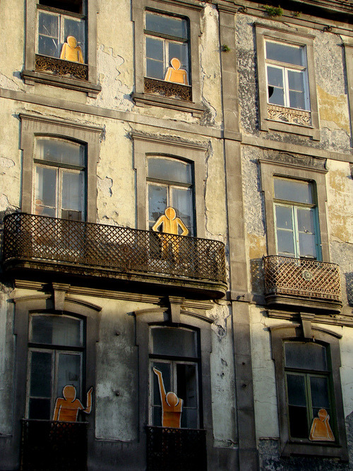
He was telling me about how beautiful the center of the city is and how it’s a UNESCO World Heritage Site. But he was also telling me how eerie it was to see so many abandoned and decaying buildings.
And part of the reason for this – I learned – is that up until fairly recently, Portugal had some incredibly onerous pro-tenant rent controls in place that dated back to the beginning of the 1900s.
Because of this, landlords in many cases could not, and cannot, actually afford to maintain their properties. Buildings were left to decay, and in some cases they were completely abandoned. That was their only option. And it led to a virtually non-existent rental housing market (according to the IMF).
Clearly, this is a problem. If you have a market distortion as serious as this one – where there’s virtually no incentive to invest – you’re on a highly unsustainable economic trajectory.
The hope was that the reforms would allow Portuguese landlords to charge more reasonable and market-oriented rents, as well as do other crazy things like evict tenants that don’t actually pay their rent. Not surprisingly, many fought the changes.
I don’t know precisely how these reforms have ultimately played out in the market over the past few years (if you do, I’d love to hear from you in the comments below), but I do believe that liberalization of the market was, and probably still is, needed.
While paying €5 a month for a 4 bedroom apartment in a desirable central neighborhood might be great for that one individual family, it’s not so great for the economy as a whole. And ultimately that comes around to impact even that household.
But by the end of it, I was just sad. As a lover of cities, it always makes me upset to see great buildings disappear. I think you too will be surprised at what I found.
The following picture depicts the north side of Front Street East, about 2 blocks east of Yonge Street. I don’t know what year it is, but look at how stunning these buildings are. It looks like Soho, New York meets some glamorous European capital.
Can you imagine what we could do with these buildings today?
If there’s any doubt in your mind that this is Toronto or that it’s Front Street East, take a look at the spire in the far left hand side of the picture. It belongs to the Toronto Board of Trade Building, which used to sit at the north east corner of Yonge Street and Front Street. When it was built in the late 1800s, it was considered one of the first “skyscrapers” in Toronto. It was demolished in the 1950s.
Here’s a picture of the Board of Trade Building so that you can compare. Again, take a look at the spire.
For those of you who might not be familiar with the area, here’s a map to help you out. The Board of Trade Building is shown on the bottom left hand corner. And the buildings in the first picture are in the triangular land area between Wellington and Front.
Now, let’s fast forward to the late 1960s. Those same buildings shown in picture number one have been demolished and in their place is the following parking lot. It’s a bit less glamorous looking. There are still heritage buildings on the south side of Front Street, but the balance of the area seems to have been blown out. What a shame.
Finally, here’s an aerial view of the area. It’s also from the late 1960s or early 1970s. You can see the same triangular land area, with only the Flatiron Building still standing at the very tip of it.
Obviously the St. Lawrence Market has come a long way since the 70s. That triangular area has since become Berczy Park, which is actually in the midst of being completely revitalized, and all of those parking lots have been filled in. But I still can’t help but wonder what the neighborhood would be like today had we preserved all of those heritage buildings.
I think cities work best when you can figure out that delicate balance between preservation and progress. It’s not always the simplest approach, but as most things in life, the right decisions are often the toughest ones to make.
“We shape the cities, and then our cities shape us.” That’s one of my favorite lines from the documentary The Human Scale, featuring Danish architect and urban designer Jan Gehl. I like it because I don’t think many of us think enough about the way in which the built environment – that we create – ultimately goes on to influence the way we live our lives.
One of the most interesting connections for me is the link between urban form and public health. There’s been a lot of talk over the years about how suburban sprawl is, or might be, making us fat (among other things). We’ve created environments that are only navigable by cars and that has forced many of us into sedentary lifestyles. We sit in our cars, and then we sit in our offices.
So today I’d like to conduct a bit of a poll. If you’d like to participate, please share the following 3 things in the comment section below: 1) your city, 2) the type of neighborhood you live in (urban, suburban, rural, etc.), and 3) the amount of time you spend walking or doing something active on an average day.
Here’s me:
I live downtown Toronto in the St. Lawrence Market neighborhood (urban). I take the subway to work and the station is a 10 minute walk from my place. So as a bare minimum, I spend at least 20 minutes a day walking. But since I also walk to do most of my regular errands, and since my gym is another 10 minute walk from my place, I’d say I average a good 30-45 minutes of walking each day.
Now it’s your turn 🙂
This is a pretty crude survey, but with the advent of things like smartwatches and health monitors, I think we’ll soon have lots of great data on the ways in which our cities might shape our health.
Last month Oxford Properties submitted a site plan application for the redevelopment of the rundown Cumberland Terrace in Toronto’s Yorkville neighborhood. If you’d like to browse the full application (including all the drawings), you can do that here.
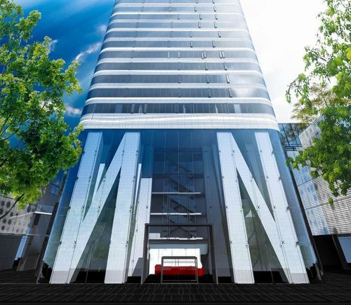
The proposal is a departure from previous plans and now includes 3 buildings: a 4.5 storey building, a 2.5 storey building, and a midblock 54 storey residential tower (the lobby is shown above). There will be both retail and residential uses.
For those of you familiar with the mall, it should go without saying that Cumberland Terrace is in desperate need of redevelopment. So I’m not going to talk about that today. Instead, I’d like to mention 2 other points that stood out to me about the application.
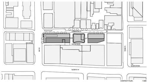
The first is the 2 midblock connections on either side of the tower, running from Cumberland Street to Mayfair Mews in the rear (see below). Yorkville has a history of intimate laneways, and so it’s nice to see some of this being carried through in a new development. It also opens up the opportunity for an improved Mayfair Mews.
Secondly, it’s somewhat surprising to see that the 54 storey residential tower is being proposed as rental. Toronto doesn’t build a lot of purpose-built rental apartment buildings. There are some (from the likes of Morguard and Concert Properties), but we haven’t done it at scale for decades. And that’s largely because the demand for condos has been so great.
But recently I’ve been noticing a renewed interest from the real estate community in multi-family rental assets. Cadillac Fairview also proposed a 65 storey rental building at the north west corner of Yonge Street & Queen Street last year – though they later withdrew their application.
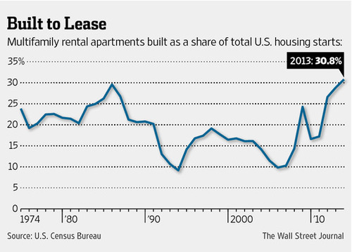
In the US, rental apartments as a share of all new housing is also at record highs – over 30%. And that’s partly because credit remains tight (certainly compared to pre-2008) and economic growth has been tepid. But also because of demographic changes. People are having fewer children, later in life, and so many are putting off buying.
So I think we’re going to see even more rental apartments being built in Toronto in the coming years.
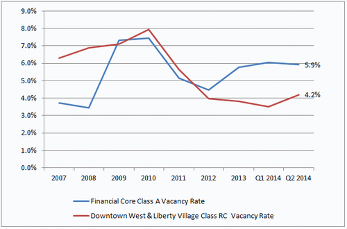
I’m sure this isn’t news to most of you. Cool loft spaces have been popular for years. But it’s interesting to look at how rents and vacancy rates have changed for these submarkets and product types over time.
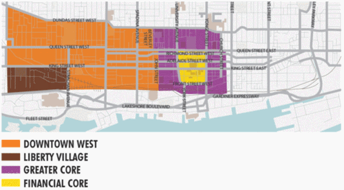
Since 2002, average (net) asking rents for brick-and-beam buildings in the west end have gone from $16.12 to $22.23 per square foot. Almost a 38% increase. By comparison, office space in the core has gone from $28.40 to $32.38 per square foot. A 14% increase.
And if you look at vacancy rates since 2007, you’ll see that the character office market has really tightened up over the past 4 years or so. There’s growing demand for a limited amount of supply.
With the growth that the downtown core is seeing and with the rise of Toronto as a creative startup hub, I’m sure we’ll continue to see strong demand for this type of space. But there’s only so much of it to go around. So I think we’ll also end up seeing greater interest in the east side of downtown and also more interesting new builds.