Daily insights for city builders, delivered every morning at 6 AM ET. I’m Brandon Donnelly — a Toronto-based real estate developer and founder of Globizen. I’ve been writing here since 2013.

  • Is Hongcouver better off than Vancouver?

    The Twilight Zone | Vancouver by Apar Sidhu on 500px.com

    https://500px.com/embed.js

    It’s raining this morning in Toronto. The sun really hasn’t come up and out yet. And I’m spending the morning drinking coffee and reading a City Journal article from this past summer called “Hongcouver.”

    The article talks about how the Chinese – first from Hong Kong and then from mainland China (PRC) – have dramatically reshaped the economic and cultural landscape of Vancouver.

    I, unfortunately (it’s a great city), don’t spend a lot of time in Vancouver and so I don’t have an accurate sense of the local sentiment towards all of this change. But there’s no question the city has changed. 

    Here’s a snippet from the above City Journal article:

    As for the notion that Chinese money tended to be ill-gotten, Yu pointed out that the property boom was propelled by the structural disparity between prosperous Hong Kong, a dynamic economy, and the comparative backwater of Vancouver, still “living on the fumes of empire.” For the price of a Hong Kong flat, a Chinese immigrant—even, say, an accountant—could buy a splendid home on Vancouver’s West Side. “The Hong Kong Chinese who came could buy their way into any neighborhood. [They] knew that money was a tool,” Yu told me. “They weren’t going to accept a second-class citizenship in Vancouver. They could say, ‘I don’t care about your British Imperial manners, I am going to buy your house.’ ” The irony was that the Hong Kong arrivals—“more sophisticated than the people they were displacing,” with “better schooling, better English accents,” Yu said—were themselves the products of a system of law and finance instituted by the British with the establishment of their Hong Kong colony in the 1840s, after Britain thrashed China in the First Opium War.

    A lot of this was fuelled by the now defunct Immigrant Investor Program. The intent of the program was to allow “experienced business people” into the country in order to contribute to economic growth. If you had business experience, a net worth of at least C$1.6 million (that was gained legally, of course), and were able to invest C$800,000, then you could get permanent residency.

    Between the mid-1980s and the end of the 1990s, approximately 30,000 Chinese came to Vancouver via this investor-class visa. And between 1987 and 1997, it is estimated that this group of Chinese possessed about $35 to 40 billion in disposable income. No wonder they bought real estate.

    But the interesting question is whether or not Vancouver is better off now than it was in the 1970s before all of this migration really took hold. 

    There many who would argue that it is not. Vancouver now has the most expensive real estate in Canada and prices have completely detached themselves from local income levels – as they have in many international cities.

    But there’s also a strong argument to be made that this influx of money has made the Vancouver economy more dynamic. Unemployment in the city was cut almost in half between the early 1980s and 1991 during the first wave of migration. It went from 13.6% to 7.7%.

    In a way, it’s not all that different than what’s currently happening in San Francisco with tech and housing. I’m not saying there aren’t problems to be solved. But I think many of us can agree that the answer is not to eradicate the tech sector.

    That’s throwing the baby out with the bathwater.
  • A sports and entertainment corridor

    On Sunday afternoon I went to see the Blue Jays. It was the last home game of the season before the postseason and the only game I’ve gone to see this season. (Thank you Chris for the ticket.)

    And what a last game it was. 

    We won 5-4, but we hustled for the win. We squeaked it out at the end with a pinch runner that stole 2nd base (and then tied the game in the bottom of the 8th) and with Josh Donaldon’s walk-off home run in the bottom of the 9th with 2 outs. I’m pretty sure the Jays were hungover from celebrating their first playoff berth in 22 years – that’s why it was so close. It certainly made for a gripping finish though.

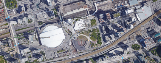
    After the game everybody was jazzed up and spilling out onto Bremner Blvd in front of the Rogers Centre. I’m not sure if it was premeditated or not, but the entire street was closed to cars. And it reminded me of something that I’ve thought for years: that Bremner Blvd should be made into a kinds of sports and entertainment corridor connecting the Rogers Centre in the west with the Air Canada Centre and Maple Leaf Square in the east.

    Bremner is not a long street. But it connects the place where Canada’s only (MLB) baseball team plays and where Canada’s only (NBA) basketball team plays. Right now it’s a fairly nondescript street. But it doesn’t have to be that way. It could be something really special.

  • Toronto housing — where we came from and where we’re probably headed

    This morning I’m working on a presentation that I’m going to be giving one evening next week to a delegation coming in from the US. The title of the presentation is the title of this blog post: Toronto housing – where we came from and where we’re probably headed.

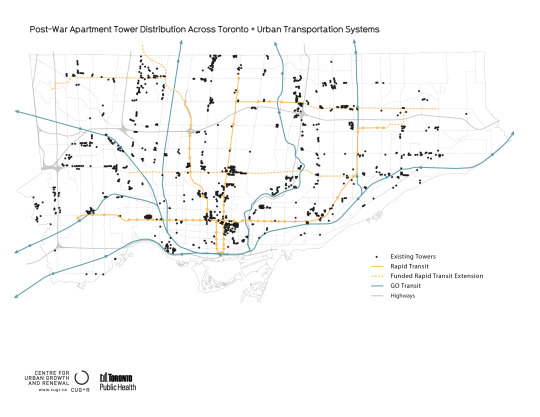
    My plan is to start in and around the 50s and 60s and talk about Toronto’s first tower boom following the war. For this time period, I’m relying a lot on the work of Graeme Stewart of ERA Architects, who is one of, if not the, expert on post war towers in this city.

    image

    I’m then going to move onto our current high-rise condo boom and compare the two.

    Because the interesting thing about the first boom is that, after it finished, we basically returned to the typical North American housing model: building single-family homes. And it wasn’t until this recent boom of the early 2000s that we once again resumed building more high-rise than low-rise housing. That is still the case today.

    But the question I want to address is really, what’s next? Where are we headed? Is history going to repeat itself or is – dare I say – this time different?

    I’ll eventually get to those questions here on Architect This City, but first I want to hear from you. So here’s what I’m proposing: leave your thoughts in the comment section below and I will feature the best ones in my presentation next week as the voices of Toronto. I’m sure many of you know that I’m a big fan of crowdsourced information.

    So here goes. Where is Toronto housing headed and how will we be living in the next 10+ years? Will we be raising families up in towers or not? Please comment by Sunday, September 27, 2015 at 6pm (ET) to make sure I have time to feature you in the presentation. 

    Thanks for participating 🙂

  • The day modern architecture died

    image

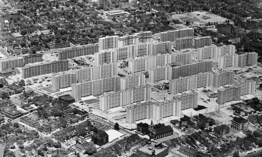
    In 1956, a large 57 acre urban renewal project was completed in St. Louis. It consisted of 33 apartment buildings, each 11 storeys tall. The entire complex was known as Pruitt-Igoe.

    Early residents seemed to really like the buildings. The first tenant, Frankie Mae Raglin, called it the “nicest place she’d ever had.” 

    But 16 years later in 1972, the first 3 buildings within Pruitt-Igoe were demolished. And in 1977, architectural historian Charles Jencks proclaimed that the day Pruitt-Igoe was demolished was the day that modern architecture had officially died.

    The modernist dream had failed. Architecture had failed us. Segregated “towers in a park” was not the way to socially engineer away poverty and slums from our cities. 

    This is the narrative that we have told ourselves, not only in St. Louis, but in cities all around the world.

    But was it really all architecture’s fault?

    Stuyvesant Town in New York (80 acres) shares many of the same architectural ideals that Pruitt-Igoe embodied and it seems to be holding up just fine. The same could be said for Lafayette Park in Detroit (46 acres), which is probably more telling given what the city witnessed in the years following 1956 – the year Lafayette Park was completed.

    So the reality is far more complex.

    Between 1950 and 1970, St. Louis lost about 30% of its population. Coming on the end, Pruitt-Igoe had a vacancy rate of 88%. Racial tensions were also surging. Here’s how the American Institute of Architects put it back in 2012:

    Pruitt-Igoe was built during a tumultuous time in U.S. race relations in a city with an intense history of racial segregation. Pruitt and Igoe were designed as separate, racially segregated projects: Pruitt for African-American residents, Igoe for whites. As the towers were going up, the Supreme Court’s Brown v. Board of Education decision banned segregation. Faced with the possibility of living next to African-American neighbors in an integrated Pruitt-Igoe, white residents moved out en masse, exacerbating Pruitt-Igoe’s vacancy problems.

    So while most cities rightfully would’t dare build in the spirit of Pruitt-Igoe today, this was not a strictly architectural problem. There is always an underlying social, political, and economic environment. And unfortunately architecture, alone, cannot solve everything. 

    If you’re interested in this topic, I recommend you check out a paper by Katharine G. Bristol called, The Pruitt-Igoe Myth.

    Image by Bettmann/Corbis via The Guardian

  • Find the best local construction professionals at the lowest prices

    One of my closest friends, who also happens to be in the same industry, is currently testing out a new construction marketplace idea. It’s called Tenderlet and it’s an online platform that helps your average house or condo owner “find the best local construction professionals at the lowest prices.”

    Right now it’s just a basic website, but he is obviously thinking that it could grow into a far more robust online marketplace.

    The way it works is real simple:

    1. You tell Tenderlet about your construction job – everything from a water damaged ceiling repair to new hardwood flooring. 
    2. Tenderlet goes out and gets multiple quotes on your behalf (just like how the professionals do it). 
    3. Then Tenderlet comes back to you with at least 3 quotes and a recommendation. It’ll even handle scheduling and payments.

    Eventually he’s imagining that there will be a mobile app, reviews for the construction professionals, and a location dimension, which can make all the difference, particularly for smaller jobs. But you have to start somewhere.

    I think he’s on to something here. I know I want to use it. So I would encourage you to check out tenderlet.com and give it a try. If you have any feedback about the idea, I am sure he would love to hear from you in the comment section below.

  • Products people love

    Ruler, compasses, eraser, protractor, pencil and tracing paper r by Alexander Melnikov on 500px.com

    https://500px.com/embed.js

    I recently heard someone say, in a pejorative way, that all real estate developers think of what they build as “products.” I imagine this is in contrast to thinking in terms of buildings as spaces for people to live, raise a family, do their life’s work, and so on.

    When I heard this I immediately thought to myself, yeah, we (or at least I) do think of our spaces as products. But I also didn’t see it as a negative thing.

    In my view, there’s no reason that classifying something as a “product” has to make it any less beautiful, functional, and/or filled with design intent. My iPhone is a product. The wine on my shelf that somebody labored over is a product. The chair I’m sitting on right now is a product. All of these items were produced by people and then I consumed them because I liked what those people had made.

    When I was completing my first master’s in architecture and real estate, I used to walk back and forth across campus between the design school and the business school. And in these two places, we talked about bricks-and-mortar in very different ways.

    In the business school, buildings were the proverbial widget. How much does this widget cost to produce? How much can I sell or rent this widget for in the market? And how do I scale up my business so that I can sell/rent more widgets?

    On the other hand, in the design school we weren’t all that concerned with the cost of the widget or even what people would pay for it. Instead we were concerned with making it something so much more than just a plain old widget. These weren’t buildings. This was capital “A”, Architecture.

    I don’t think either school was wrong in their thinking. I just think they were missing each other. 

    Business is business. If you don’t make a profit then you’re not going to be around for very long. And while many companies can survive by making shitty products, those aren’t great businesses. The best businesses also deliver products that people absolutely love.

    So whether we call it architecture, a product, or even a widget, the goal should be to delight people. (Am I allowed to say “customer”?) Make people so happy that they have to tell their friends about it. If we’re doing that, then frankly I don’t care what we call it.

  • The housing typologies of American cities

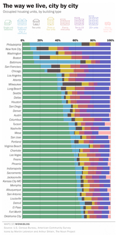
    Yesterday the Washington Post published a great chart showing the housing types of the 40 largest cities, by population, in the US. The list is ordered from lowest to highest according to the percentage of single-family houses in the city (green bar).

    Here’s the chart:

    image

    Not surprisingly, many of the cities at the top of this list (meaning they have the lowest percentage of single-family houses) are in the older east coast cities. 

    It’s also interesting to see just how much the rowhouse dominates the urban landscape in Philadelphia and Baltimore. In Philadelphia, almost 60% of the housing stock is an attached rowhouse.

    Housing is the backdrop for such a big portion of our lives. And when you live in a particular kind of home, it impacts your life whether or not you realize it. The dense rowhouses of Philadelphia and the single-family houses of Oklahoma City are the result of two very different kinds of urban landscapes.

    In Toronto, that backdrop is in the midst of a dramatic change. More and more of us are now living in high-rise condos. That hasn’t always been the case, of course. It’s a recent shift. But it looks like it’ll be a big part of our future.

  • Mega-cities vs. networked cities

    Morning fog by Yijiang Wu on 500px.com

    https://500px.com/embed.js

    Ed Glaeser, Giacomo Ponzetto, and Yimei Zou recently published a new academic paper called, Urban Networks: Spreading the Flow of Goods, People and Ideas

    The paper looks at whether it’s more advantageous to build huge and consolidated mega-cities or build connected networks of smaller urban centers (perhaps connected by high speed rail). As countries like China rapidly urbanize, this is something that many people are thinking about.

    In China, there is a lively urban planning debate
    about whether to facilitate the increased expansion of the vast agglomerations of Beijing and
    Shanghai or whether to focus on creating networks of cities that are smaller, albeit still much
    larger than almost all of the cities of Western Europe. The current government policy favors
    networks, in the hope that connected smaller cities may be free of the extreme downsides of
    mass agglomeration, such as extreme congestion, pollution and high housing costs.

    Like most things, there are real trade-offs. 

    In the paper, they assume that larger cities lead to more urban amenities, which in turn serves as an important magnet for skilled workers. However, for unskilled workers who may not care/benefit from the same urban amenities, it is possible for them to dislike the bigger cities. In this case, the benefits do not outweigh the negatives of urban expansion and an urban divide is created (rich/poor).

    One of the potential negatives is housing.

    The attraction of denser, not larger, mega-cities is determined also by the elasticity of
    housing supply. When it is easy to add extra homes on a narrow plot of land, as in Texas,
    then density becomes more attractive. European urban networks may well be the right
    answer because history and regulation makes it so hard to build in Europe’s older cities.
    Even though China has usually been quite friendly towards skyscrapers, the sheer scale of
    the Chinese population may still make the case for urban networks.

    If you’re interested in this topic, there’s a section (#2) in the paper on the history of urban networks that you might like.

  • Vancouver never plays itself

    There’s something powerful about seeing/hearing cities being depicted in film, TV, and other kinds of pop culture. It creates familiarity and does a lot to drive the brand of that place.

    But how often are you just seeing one city disguised to look like another? Actually quite often.

    Here’s an interesting video that talks about how the 3rd largest film production city in North America never actually plays itself.

    [youtube https://www.youtube.com/watch?v=ojm74VGsZBU?rel=0&w=560&h=315]

    I know that there are real economic benefits to being a cheap place to film movies, but I would love to see Canadian cities play themselves. There are also big benefits to that.

    Thanks to Scott Bonjukian at The Urbanist for sharing the above video this morning.

  • From map books to Google Maps

    When I was a kid I remember my parents having something called a “Perly’s” in their car. It was basically a map book and it was the best thing around. 

    You would start by looking at a big grid of the city and then you’d find the specific area you were looking for and then flip to that page. If you were on the road a lot for work, a Perly’s was a mandatory addition to your car.

    Things have obviously come a long way since then. It could take you a long time to find the street you were looking for in a Perly’s. I remember doing that from the passenger seat. Now our phones do that for us and if the connection makes us wait for more than few seconds, we get irritated.

    But we’ve also moved beyond just static maps. 

    The other morning I was driving out to the suburbs and I saw this road sign telling me that – given current traffic conditions – it was going to take me 15 minutes to get to HWY 427. 

    image

    Have you ever wondered how they come up with those time estimates?

    There are a few ways to do it. But here in Toronto along the Gardiner Expressway and Lake Shore Boulevard it’s done using your mobile phone. Phones have unique network identifiers called MAC addresses. And when they try and connect via Bluetooth or Wifi they actually send out their MAC address.

    So what happens as you’re driving along is that your phone’s MAC address is being picked up at various locations. And since the distance between these various reception points is known, it’s pretty easy to determine how fast you’re traveling. That’s how they come up with those time/traffic estimates. 

    This data is anonymous but, in theory, the city also knows if people are speeding when the traffic is light.

    This same technology is being used by many retailers and shopping malls to track how people move through their spaces. It’s used to see, among other things, which merchandising strategies are working and what synergies one might be creating (or not creating) with the tenant mix.

    But getting back to traffic, there are obviously ways to collect traffic data without any additional physical infrastructure.

    As I was about to leave the suburbs and head back downtown, my phone somehow knew I was about to do that (perhaps because I was stopped at a Starbucks near the highway) and so it decided to tell me this:

    image

    It wasn’t the best notification to receive on my phone, but I was impressed nonetheless. This traffic data is collected using GPS data transmitted from mobile phones using Google Maps, Apple Maps, and so on. Clearly we’ve come a long way since the days of manually leafing through a thick Perly’s.

    At the same time, it feels like we are still pretty far away from solving the problem of urban congestion. Every big city in the world is grappling with this issue

    Part of the problem, I think, is the belief that there’s some sort of silver bullet – more highways, a magic smartphone app, and so on – that will enable everyone to be able to drive around in their own car by themselves. I don’t believe that’s possible in big cities. And the sooner we get away from that toxic thinking, the quicker we’ll solve this problem.