Daily insights for city builders, delivered every morning at 6 AM ET. I’m Brandon Donnelly — a Toronto-based real estate developer and founder of Globizen. I’ve been writing here since 2013.

  • High resolution population maps

    image

    Facebook, as part of their internet.org initiative, is working on bringing internet access to people in rural areas all across the world. For obvious socioeconomic reasons, this is an important initiative. From a business standpoint, it also grows the base of potential Facebook users at a time where that top line number is starting to plateau.

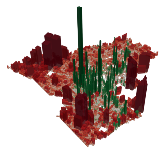
    In order to understand how people are settling and aggregating throughout the world, Facebook has been using high-resolution population maps and then creating models to drill down and analyze individual buildings. 

    This is interesting because: how else could you track informal settlements? So far this seems to be the most effective method. In fact, in architecture school I worked on a project in Dhaka, Bangladesh and I remember relying heavily on aerial photography because I simply couldn’t find the data I was looking for.

    Here’s an excerpt from a recent World Bank post. They, along with Columbia University, are collaborating with Facebook.

    Facebook’s computer vision approach is a very fast method to produce spatially-explicit country-wide population estimates. Using their method, Facebook successfully generated at-scale, high-resolution insights on the distribution of buildings, unmatched by any other remote sensing effort to date. These maps demonstrate the value of artificial intelligence for filling data gaps and creating new datasets, and they could provide a promising complement to household surveys and censuses.

    And here’s an excerpt from a recent Facebook post on the same topic:

    From this preliminary analysis, we’ve determined that slightly less than 50% of the population lives in cities. However, 99% of the population lives within 63 km of the nearest city. Hence, if we are able to develop communication technologies that can bridge 63 km with sufficiently high data rates, we should be able to connect 99% of the population in these 23 countries. [”These 23 countries” represents about 1/3 of the world’s population.]

    I would imagine that this type of model works better in sparsely populated / low-rise areas. Still, I am very interested in thinking about ways in which our current survey and census methods could be improved. Here in Canada we conduct our national census every 5 years. In today’s world that feels like eons. One day, I am sure, it will be real-time.

    Image: World Bank

  • Show some laneway love

    I just want to do a quick follow-up to my recent post about the momentum currently developing around laneway housing here in Toronto. 

    In the post, I mentioned that two councillors have come out in support of this housing typology. However, I neglected to mention that Evergreen CityWorks is also at the table, as well as a housing advocacy group called Lanescape. It was mentioned in the comments, but I know that not everyone checks that part of the blog.

    I say this for two reasons:

    1) I thought about starting a similar initiative to Lanescape. (I’ve had lanewaylove.com registered for many years. Brand identity shown above.) But after meeting one of the Lanescape founders this past week, I think it only makes sense for me to instead throw my support behind them. They are accomplishing a lot in this space.

    2) Lanescape has a survey up on their website and the results will be used to guide a laneway suite planning framework that will (hopefully) be implemented by the City of Toronto. So I wanted to encourage you all to complete it. Even if you don’t live in Toronto, still fill it out. It’s important for cities to learn from each other.

    Your support will go a long way in making laneway housing a reality in the city.

  • Yellow trees

    I took this picture on a recent trip to New York:

    image

    I liked the mid-block building and so I wanted to document it. That’s what I do when I walk around a city.

    When I went back to research the project later on, I then discovered that it was developed by DDG Partners, which I have been following for years. I think they do terrific work and I love their vertically-integrated approach to real estate development. Two years ago I mentioned them in a post called: 3 architects operating as developers.

    If you’d like to learn more about the project, you can do that here. It’s called 345MEATPACKING. 

    What I want to talk about today is how they wrapped the building during construction. Working with the Japanese artist Yayoi Kusama – who at the time had an exhibition going on at the Whitney – they created a 120-foot reproduction of her painting Yellow Trees.

    Here’s a video of what that looked like (c. 2012). If you can’t see the video below, click here.

    [vimeo 79792779 w=640 h=360]

    What a great idea. But don’t tell anyone. I want to steal the idea for one of my projects.

  • Toronto mayor proposes road tolls, finally

    When I wrote yesterday’s post about road tolls, it hadn’t been announced that Toronto Mayor John Tory was going to call for road tolls on both of the highways coming into downtown. That didn’t leak until late in the evening. So I was just writing another post on a topic that I care about.

    Today, however, that announcement was made and the proposal is a flat $2 toll on both the Gardiner Expressway and the Don Valley Parkway. It is expected that this could bring in close to $200 million a year in new revenue for the city – all of which would be dedicated towards transit and roads. Good.

    First, I want to applaud the mayor for coming out in support of road pricing. I didn’t agree with him on the Gardiner East, but I agree with him on this – mostly. It is a bold move.

    The reason I say mostly is because I hope that we don’t simply default to a fixed and blunt road toll. There are more sophisticated options out there, such as variable pricing models that change based on demand/congestion levels.

    Here’s a post that explains how that works and why I think it’s a good model.

    With this approach, it becomes more of a congestion charge rather than a toll. It also gives commuters the option of driving during off-peak times to save money. And if we implemented something like this, I am sure that we would see employers and office hours adapt. More on this in the above post.

    Still, I absolutely believe that it’s a step in the right direction for this great city. So thank you Mayor Tory.

  • Revisiting road pricing

    Following the Toronto Transit Commission’s approval of a 10-cent fare hike, Cherise Burda of the Ryerson City Building Institute penned an article titled: It’s time for Toronto to consider road tolls.

    I am a big supporter of road pricing and I have written a lot on this topic over the years. There’s even a guest post by Darren Davis on this blog – he is a transport planner with Auckland Transport. 

    I don’t have much to add right now, but I did want to help promote Cherise’s post and I did want to link back to all of my previous posts (including Darren’s). Click here for a list of posts tagged with “road pricing.”

    There’s a mental model in Toronto, and many other cities, that remains centered around subsidized roads and artificially low residential property taxes. Because, well, that’s the dream.

    Nobody wants to pay more for anything – I get it. But I think we can all agree that this region has not solved the traffic/mobility problem. In fact, it’s one of our biggest weaknesses. 

    So what are we going to do about it? I reckon the answer is something other than the status quo.

  • Carriage house disruption

    The Spaces has a post up called: 7 carriage houses on the market in New York City. They’re all quite expensive. The house on East 63rd designed by Paul Rudolph is particularly interesting. But that’s not what I want to talk about.

    As I was going through the photos – that’s what The Spaces does best – I thought of two things.

    First, there’s a segment of the market that is obsessed with living in spaces that were not originally intended to be used as residences. That’s what (hard) lofts are. That’s what carriage houses are. And that’s partially why I would love to live in a laneway house (Toronto vernacular).

    Backhouses, as they are also called, were initially designed to hold horse and carriage. But as horses disappeared from New York City, the structures got repurposed.

    Here’s one theory for how that went about:

    Barry Lewis, an architectural historian, theorizes that rear buildings became residences to accommodate the 19th-century immigrant population that moved into middle-class areas in Lower Manhattan in the 1830’s and into the Village and Brooklyn after the Civil War. “Backhouses seem to belong to the era of houses in Manhattan, not the era of apartments,” Mr. Lewis said. “The property owner probably shoved more immigrant families into the stable or workshed in the back. Other owners may have built a new backhouse just to get the lucrative immigrant rents.

    The second thing I thought about is the potential parallel between this story and the one being written right now. It feels like a transportation revolution is upon us and changes in mobility always seem to rewrite the landscape of the city.

    Hopefully that will mean more laneway houses in Toronto.

  • European cities by rail connectivity

    This is a terrific set of maps published by The Washington Post (2015) using data originally collected and published by Peter Kerpedjiev:

    What they show is how far you can travel in a 24 hour period using only trains and brisk walking from a collection of 28 European cities. In a few cases, such as from London to Dublin, a ferry ride is also included.

    Here’s a zoom in on London:

    The obvious takeaway is that Western Europe is very well connected, whereas many parts of Eastern Europe are not. Some cities, such as Tallinn (Estonia) and Podgorica (Montenegro) are almost completely disconnected.

    Of course today there’s stiff competition from air travel.

  • The link between ancestry and foreign direct investment

    Below is an interesting example of how international migration – and being open to it – can have positive economic impacts by way of increased foreign direct investment (FDI). The excerpt is from the World Economic Forum.

    “…we document that FDI follows the paths of historical migrants as much as it follows differences in productivity, tax rates, education, and other conventional determinants of economic competitiveness – for the average US county, doubling the number of individuals with ancestry from a given origin country increases by 4 percentage points the probability that at least one firm from this US county engages in FDI with that origin country, and increases by 29% the number of local jobs at subsidiaries of firms headquartered in that origin country.”

    Their study also found that these ties are long lasting. That is, even after a few generations of assimilation, ancestry still has an effect on FDI patterns. 

    There are of course many other benefits to open borders. But our collective tolerance toward immigration has ebbed and flowed greatly over time. And my sense is that if often has a relationship with prosperity.

    As long as times are good and I – the incumbent – am winning, then immigration is accepted, if not welcome. But as soon as times become scarce, then I – the incumbent – need to start protecting my nest.

    This may be one of the reasons why Canada seems to fair so well when it comes to diversity. We optimize for the middle more than countries like the US.

    An example of this phenomenon can be found in the mid-19th century California Gold Rush. By 1876, the United States had approximately 151,000 people of Chinese ancestry and about 116,000 of them were in the state of California.

    In the early days of the rush, when gold was abundant, it has been said that the foreign Chinese laborers were well received. But as gold became more scarce and difficult to find, Californians began to believe that the Chinaman was stealing their wealth.

    In 1882, the US signed the Chinese Exclusion Act, which flat out prohibited the immigration of Chinese laborers. It was not repealed until 1943. However, the Chinese still found other creative ways to enter the country (see Lo Mein Loophole).

    I say all this simply to provide a bit more context. We can talk about how disruptive technologies are squeezing the middle class in new and profound ways. But in many ways, we’ve all heard this story before.

  • What could a connected lockbox mean for the residential real estate business?

    image

    I just discovered an interesting Dallas-based startup this morning called TOOR. They were on Shark Tank and haven’t yet launched their product, but it’s essentially a connected lockbox. Lockboxes are a mainstay of the residential real estate industry (they hold the keys so that co-operating agents can show a property) and they are becoming even more common nowadays because of Airbnb rentals.

    What caught my attention about TOOR is the app that goes along with the lockbox that also allows people to search for homes. Once you’ve found a home you can even find an agent for an escorted tour. I’m not clear on the exact workflow, but I am thinking that if you buy this connected lockbox you then have the opportunity to put your home up for sale on their platform.

    This is interesting because the app will also verify user identities and scan people’s IDs, so it helps to solve the security problem that agents today now solve. I could imagine the app storing my credit card so that if I go into a home unescorted and I do something mischievous, it then charges me. It also makes it really easy to just drive around and pop into homes by instantly scheduling appointments.

    In any event, I may have the exact user flows a bit wrong, but it’s fascinating to think about how something as simple as a connected lockbox could start to chip away at the status quo.

  • The Human City

    As a follow-up to yesterday’s post about fluid labor markets and urban density, I thought I would present an opposing view.

    Joel Kotkin is a well known geographer and author. He has published a number of books, the most recent of which is called, The Human City: Urbanism for the Rest of Us. He is also well known as a supporter of the suburbs, which is a somewhat contrarian view in today’s urban-centric world.

    Here is a recent interview he did with Aaron M. Renn (click here if you can’t see it below):

    [soundcloud url=”https://api.soundcloud.com/tracks/257309155″ params=”auto_play=false&hide_related=false&show_comments=true&show_user=true&show_reposts=false&visual=true” width=”100%” height=”450″ iframe=”true” /]

    One of his messages is that the urban core is great for young people without kids, but that we shouldn’t expect it to serve everyone’s needs and wants – particularly those of families. Families need space and affordability, and urban cores are simply not engineered for that.

    Long live the suburb.