Daily insights for city builders, delivered every morning at 6 AM ET. I’m Brandon Donnelly — a Toronto-based real estate developer and founder of Globizen. I’ve been writing here since 2013.

  • Urbanizing the suburbs

    Commuter rail has typically functioned as a way to bring people from the suburbs into downtown for employment, and sometimes recreation. That has typically translated into good inbound service in the mornings, good outbound service in the evenings, and mediocre service the rest of the time. It has also historically meant lots of subsidized surface parking. Free parking was (and still is) often thought of as the key to putting bums in seats and increasing ridership.

    Here in the Toronto region, this service is provided by GO Transit, which, since 2009, has been owned by Metrolinx. But as one of the fastest growing regions in North America, this kind of service and thinking has become increasingly antiquated. That’s why Metrolinx and the Government of Ontario are working to profoundly change the economic geography of this region by both electrifying the lines and implementing 15 min, all-day two-way service. 

    This may seem like an incremental improvement, but it is not. It is a significant change that will transform the service from commuter rail to regional express rail. Of course, this now means that it is time to rethink the land use policies and built form that surround these key transit nodes. One of the places where this is happening today is at the Clarkson GO Station. The City of Mississauga is in the midst of a planning study that will ultimately guide future development around the station. 

    I think this one of the most important shifts taking place right now in this region and elsewhere. It is the maturation of our suburbs and it is going to result in more walkable and vibrant urban places across our cities. So if you have a few minutes, I would encourage you to complete this survey that the City of Mississauga recently put out. The results will help to guide their Clarkson Transit Station Area Study. 

    I also think think it is worth completing the survey even if you aren’t local to the area. How to urbanize the suburbs is a universal problem.
  • International Blockchain Real Estate Association

    I was at a Proptech dinner earlier this week (graciously hosted by Venturon) and I was introduced to the International Blockchain Real Estate Association (also known as IBREA). I feel like I should have known about this group. They have over 5,000 members and host an annual summit focused on blockchain + real estate.

    They have several videos from this year’s summit up on their website – everything from blockchain for titles to the tokenization of real estate assets. There are also a number of industry working groups that have been set up, which bring companies together around specific problems and ambitions (such as, creating a universal property identifier).

    To get you started, here is Blockchain Real Estate 101. If you can’t see the video below, click here.

    [youtube https://www.youtube.com/watch?v=1WcLOcWyfHk&w=560&h=315]

  • Photoblog: Sunrise at Ten York

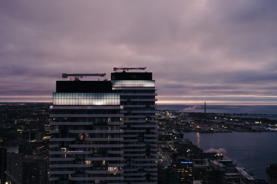
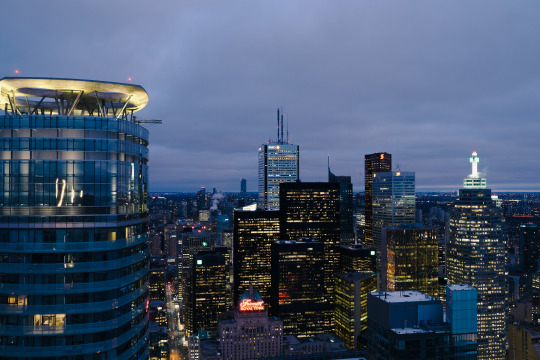
    This morning I watched the sun rise from the the roof of Ten York Condominiums, some 735 feet up. This is what that looked like (the sky initially had a purple hue to it):

    It was cold as all hell, but sometimes you have to work for your photos.

    Some of you may also remember that I wrote about this building a few months ago. Tridel, the developer, is calling the project its first “smart condominium.”

    Regular scheduled programming will resume tomorrow.

  • Emma + Justin

    image

    Okay, I promise that after this post I will stop talking about the Forever mural that Ben Johnston recently completed at Junction House – at least for a little while. 

    I admittedly don’t know Emma and Justin, but I would like to congratulate them on their recent engagement at Junction House.

    Emma thought they were going to take anniversary photos, but instead Justin proposed in front of Forever. If you can’t see the embedded photo below, click here.

    //www.instagram.com/embed.js

    Forever certainly feels like the right message to me. Congratulations Emma and Justin.

    P.S. Junction House was in the National Post over the weekend. Link.

  • Multi-storey retail

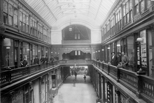
    I was at the St. Lawrence Market over the weekend and I saw a poster up for the original Yonge Street Arcade building, which was located at Yonge Street and Temperance Street here in Toronto. Initially constructed in 1884, the building was ultimately demolished in 1952 and replaced with today’s building by 1960.

    Here is a photo of the original arcade dated 1885:

    image

    The Yonge Street Arcade has been fairly well documented online (check out here and here). But what interested me when I saw the poster was the building’s retail characteristics.

    Modeled after the glass-roofed malls being constructed in Europe at the time – the Galleria Vittorio Emanuele II opened in Milan in 1867 – the Yonge Street Arcade is said to be Canada’s first enclosed shopping mall.

    The galleria was 267 feet in depth and 3 storeys high (pictured above). The ground floor contained 32 retail units, each 12 feet wide by 29 feet deep. 24 of the units were in the galleria and the other 8 faced outward toward each street frontage.

    On the 2nd floor were 20 more units. Some sources say they were intended to be offices, while others say they were retail units. The above photo makes me think they were retail. The 3rd floor then had offices and maybe some artist studios.

    Either way, the mix of uses is interesting (and maybe a first for Toronto). And if you know anything about retail, you’ll know how difficult it can be to successfully pull it off across multiple levels. The Yonge Street Arcade shows that we’ve been (possibly) trying it for well over a hundred years in this city.

  • Morning ravine walk

    Yesterday morning I went on a ravine walk from Summerhill up to St. Clair Avenue East. Toronto’s ravine system is easily the most unique feature of our city’s geography. Architect Larry Wayne Richards once described the topography of Toronto as San Francisco inverted. They have hills and we have valleys.

    Toronto’s ravines serve, among other things, as a recreational treasure, a magnet for nice homes, and as an important component of this city’s water infrastructure. But as you walk through many of our ravines, you can’t help but think that we could and should value them a lot more.

    I appreciate that there needs to be a balance between environmental conservation and recreational use, but that doesn’t seem to be the primary issue. It is neglect. And it is probably because they are out of sight and out of mind for many people. Toronto’s ravines are an undervalued asset.

  • Sidewalk Toronto releases draft site plan for Quayside

    Yesterday Sidewalk Toronto released its draft site plan for Quayside. Here’s what it looks like:

    There’s a big emphasis on people-first streets and on the public realm. I like the idea of a waterfront plaza at the tip of the Parliament slip and of a floating walkway bridge to Promontory Park (bottom right hand corner of the above image).

    There are also a number of more enclosed pedestrian laneways and courtyards, which I am sure will result in more favorable microclimate conditions. That matters, especially on the water.

    Here are some high level project stats:

    • All mass timber construction
    • Five “sites”
    • Buildings ranging from 3 to 30 storeys
    • 68% residential (40% of the residential will be below-market, with 20% being affordable and 5% being deeply affordable)
    • 20% commercial
    • 15% flex space (retail, production, arts, community)
    • ~2,500 residential units

    A full copy of the draft site plan can be downloaded, here.

    Image: Sidewalk Toronto

  • Airbnb announces new Backyard initiative

    Airbnb has just announced a new initiative called Backyard, where it will be looking at new ways in which homes can be designed, built, and shared. They are, in a broad sense, becoming architects.

    The initiative has been in the prototyping phase for some time now, but the plan is to put forward some sort of product in 2019. Despite the name, the initiative won’t just be focused on small backyard cottages or accessory dwelling units.

    Here is an excerpt from Fast Company:

    “Backyard investigates how buildings could utilize sophisticated manufacturing techniques, smart-home technologies, and gains vast insight from the Airbnb community to thoughtfully respond to changing owner or occupant needs over time,” Gebbia says. “Backyard isn’t a house, it’s an initiative to rethink the home. Homes are complex, and we’re taking a broad approach–not just designing one thing, but a system that can do many things.”

    This is yet another example of tech and real estate coming together. But as I’ve mentioned before on the blog, I think eventually we’ll stop making that distinction; it will just become the way in which we build companies.

  • How road pricing impacts income groups

    The Pembina Institute has just published this report looking at the impact that road pricing could have on the various income groups across the Greater Toronto and Hamilton Area. One of the common arguments against road pricing is that it disproportionately impacts lower income folks.

    The study specifically looks at the proposal that Toronto put forward in 2016 to apply a flat congestion charge of $2 on the two highways leading into downtown. The proposal was ultimately rejected by the province, but I thought it was a step in the right direction. In my opinion, a dynamic road pricing model, similar to what is used in Singapore, would be preferable.

    The report concludes by arguing that road/mobility pricing is destined to become a tool in this region if we are serious about managing congestion. However, they also note that it must coincide with a strong and sustained investment in transit. And I would agree with that. That’s one of the reasons why you do this – to fund transit.

    To download a PDF of the report, click here.

  • How London became the center of the world

    Some of you may want to debate the “center of the world” title (New York may be more deserving), but Laura Parker of National Geographic recently published a great essay describing the tremendous growth that London has seen over the last 30 years thanks to in part the deregulation of the financial services industry. Here is an excerpt:

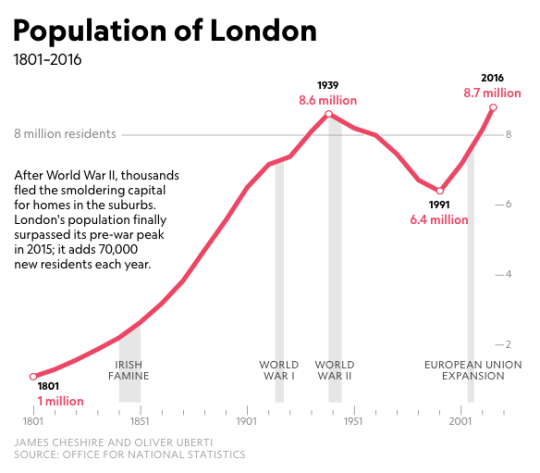
    As the manufacturing industry splintered, the docks of what was once the world’s largest port fell victim to shipping modernization and closed. The death in 1965 of Winston Churchill, the great prime minister, marked “the last time that London would be the capital of the world,” the Observer noted. Population continued a downward slide, bottoming out at 6.7 million in 1988. By then London’s fortunes had changed with deregulation of the financial services industry, known as the Big Bang, along with the shift to electronic trading, which enabled London to rival Tokyo and New York. A new financial district rose on the ruins of the West India Docks on the Isle of Dogs, a marshy nub that juts into the Thames. Canary Wharf, as the district is called, became London’s first modern large-scale regeneration project.

    According to National Geographic, London’s population grew by about 1.2 million between 2006 and 2016. That’s a pretty incredible number and is why the city estimates that they need about 66,000 new housing units a year just to keep up the growth. Like many supply constrained big cities, they’re not meeting that target.

    For the full essay, click here. It comes packaged with some incredible photographs by Luca Locatelli.