Daily insights for city builders, delivered every morning at 6 AM ET. I’m Brandon Donnelly — a Toronto-based real estate developer and founder of Globizen. I’ve been writing here since 2013.

  • Rules for location data

    The CEO of Foursquare — Jeff Glueck — published an interesting op-ed in the New York Times today, calling on Congress to regulate the location data industry. Currently, there are no formal rules in place.

    In case you’re not aware, Foursquare is one of the largest independent companies operating in this space. I have written about them many times before on the blog.

    Here’s an excerpt from Jeff’s op-ed explaining why this matters:

    But location data can also be abused. Bounty hunters were able to buy the current location of a cellphone for $300, Vice reported, because telecom companies sold the real-time location of phones to shady companies. And apps that track location data may turn around and sell that data, revealing someone’s every movement — whether it is to a retail store, an abortion clinic or a gay bar. Bloomberg Businessweek recently reported on a company with thousands of cameras selling car locations to debt collectors and others; there is no “opt-in” involved, and it’s illegal in all states to cover your license plate.

    I am writing about this today because I think it’s relevant to city building. Location data is inherently spatial. It is how we exist in cities. So it shouldn’t come as a surprise to any of you that this is valuable information — hence why it is being abused.

    Here we have a company advocating for more, not less, regulation. They, of course, want it to be sensible. But I still think it says things about the current location data environment. To learn about the specifics of what Jeff is proposing, click here.

  • A small site solution: Inverse Density

    My recent post about minimum project sizes triggered some great follow-up discussions over email. Today, I learned about a Master Plan that was recently completed for Little Havana, Miami by the urban design and planning firm Plusurbia.

    In it, they try to address some of the problems that I described in my post through something they call “Inverse Density.” Given the tendencies toward larger projects, they are proposing to incentivize the development of smaller and underused lots with more density.

    The idea being that if you can encourage more smaller scale development, you can actually help to protect the character of a place. In 2017, the National Trust for Historic Preservation declared the neighborhood a national treasure.

    Here’s a screenshot from the plan:

    What you are seeing here is existing vs. proposed policies. The proposed scenarios both result in higher densities, even though the lots are smaller. Alongside this, they are proposing to get rid of parking minimums for lots less than 7,500 sf.

    It’s an intriguing idea and I’m glad they shared it with me. If you’d like to download a copy of the full Little Havana Master Plan, click here.

  • New mural coming to Yonge + St. Clair

    A new mural is underway at Yonge + St. Clair by the Toronto-based street artist birdO (aka Jerry Rugg). He started over the weekend and should be finished by next week, depending on the weather. Here is what it looks like so far:

    If you’d like to take a look in person, head on over to 1 St. Clair Avenue East. It’s the building at the southeast corner of the intersection. And if you’d like to learn more about birdO, here’s a short film about some of his work in Detroit. It’s really well done.

    If you can’t see the video above, click here.

  • Paris and Vancouver population densities compared

    In this January 2018 report from the Fraser Institute, they pegged the average population density of Paris to be about 21,067 inhabitants per square kilometer (2014 population year). It is the second densest city in their report after Hong Kong, but the densest in Europe. By comparison, Vancouver sits at around 5,493 inhabitants per square kilometer (2016 population year).

    Now, these are of course city averages. Some neighborhoods will be higher and some will be lower. According to a January 2018 study by Alasdair Rae — who is a works in the Department of Urban Studies and Planning at the University of Sheffield — these are the most densely populated square kilometers across Europe (or at least within the 39 countries that he looked at).

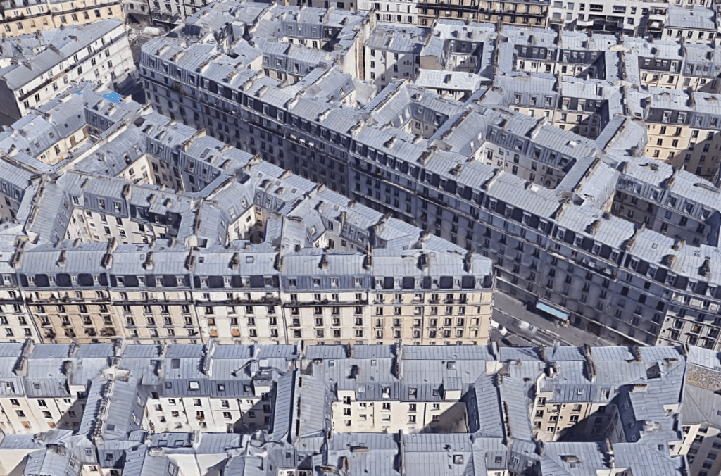
    Paris, once again, comes in near the top with a peak density somewhere around 52,218 inhabitants per 1km square. The square in question is in the neighborhood of Goutte D’Or. And the only square within the study to come in denser is one from the L’Hospitalet de Llobegrat in Greater Barcelona (53,119 inhabitants per square kilometer).

    Now let’s take a look at how these sorts of densities actually manifest themselves. Below is an aerial capture from Google Maps showing a section of Goutte D’Or in Paris. The buildings are all pretty much 7 storeys (mid-rise), but the blocks are mostly filled in. Lots of interior courtyard apartments. This is one way to get to over 50,000 people per square kilometer.

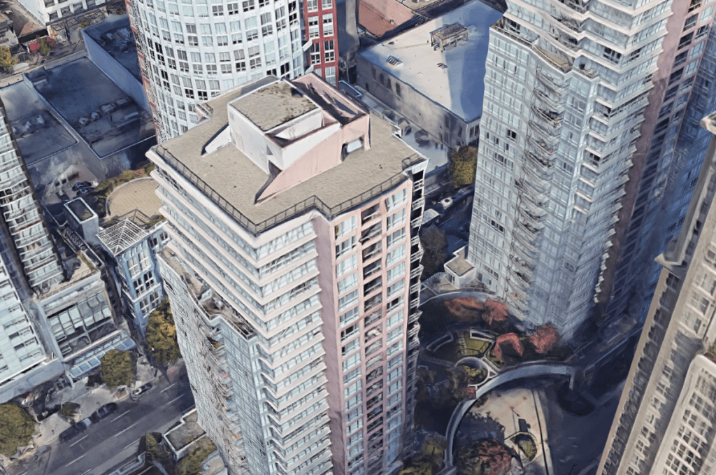
    Returning to Vancouver as a point of comparison, below is an aerial capture from downtown Vancouver at exactly the same scale as the Paris capture. I couldn’t find a density map of downtown, but it’s probably safe to assume that it’s greater than 5,493 and a lot less than 52,218 residents per square kilometer.

    What you see here is typical Vancouverism. Lots of slender point towers, careful tower positioning and spacing, and generally low podiums. It is a perfect demonstration that height and density do not necessarily correlate. It is possible to have low buildings and high density, which is something that Europe obviously does very well.

    But here’s the important question: In which of these two examples would you rather live? Please leave a comment below.

  • Minimum project size — how small is too small?

    Many, or perhaps most, developers I know have a minimum project size that they will work on. That’s why you’ll hear people say, “No, that project is too small. I need at least X square feet or Y number of units.” Given that smaller scale development such as laneway housing and “the missing middle” are so in vogue today, I thought I would discuss some of the reasons why scale matters.

    But first, it’s worth mentioning that “laneway suites,” as we have structured them here in Toronto, are intended to be built by individual homeowners and not by developers. The lots can’t be severed and most lots will yield less than 1,000 square feet. So this is a bit of a unique circumstance. As most of you know, I am a big supporter of this initiative.

    When you get into larger developer-led projects, it’s a different ball game. For one, it’s hard to even find sites. And good luck if you need to deal with multiple owners as part of an assembly. Most landowners have pricing expectations that do not even remotely align with “missing middle” level densities.

    But assuming you’ve been able to find land at a reasonable price, you still have to contend with the fact that projects have a lot of fixed costs, as well as diseconomies of scale. In other words, there are schedule, cost, and resourcing considerations that won’t change no matter how big or small you go. It’s still going to take this long and cost this much, and you’re still going to need a set of humans to manage it through.

    This can then create a situation where there’s not enough margin for error. The project is simply too small to absorb any shocks, such as an unforeseen delay or an unforeseen groundwater concern that is now adding millions to your project budget. There’s a lot of risk with development and it’s prudent to have contingency room. That’s harder to do with smaller projects.

    The other problem developers run into with smaller projects is that the construction subtrades also tend to think of them as smaller projects. They have their own set of fixed costs and margins to worry about. So unless you happen to catch them with an opening in their schedule, you run the risk of them telling you they’re too busy or them giving you a stinky price, which is just another way of them saying they don’t want the job.

    On top of all this, there’s minimum project size inflation. If capital is not a constraint, there’s a tendency to want to do bigger projects (see above). And because the cost of everything keeps going up, it’s simultaneously getting harder and harder to make smaller projects pencil; unless you, maybe, go ultra luxury and ultra exclusive. But that’s kind of the opposite goal of this whole “missing middle” movement, is it not?

    Photo by JOHN TOWNER on Unsplash

  • Look what fits in a parking lot

    Brent Toderian likes to start Twitter hashtags that revolve around city building. One of his most recent is #LookWhatFitsInAParkingLot. For this one, he asked the Twittersphere to consider the things we love in cities that might fit inside a parking lot.

    Here is one of the best responses — Dodger Stadium edition:

    https://twitter.com/pw3n/status/1176349879154556931?s=20

    Venice, Amsterdam, and Shibuya (Tokyo) were all overlaid — at the same scale — on the surface parking surrounding Dodger Stadium. There are about 16,000 parking spaces, which actually take up more land than the stadium itself.

    To be fair, I bet if you overlaid parts of Los Angeles on this same parking, it would look similarly astounding. But that shouldn’t change what you take away from this post: parking is very land consumptive.

  • What you do is who you are

    I very much enjoyed Ben Horowitz’s last book called, The Hard Thing About Hard Things. In fact, five years later, I still find myself going back to it in my mind, particularly the bits about high quality decision making.

    So I am looking forward to his latest book about how to create and sustain the kind of business culture that you want. It’s called, What You Do Is Who You Are, and that should give you a sense of where this is going.

    Here’s an excerpt from Ben:

    Because your culture is how your company makes decisions when you’re not there. It’s the set of assumptions your employees use to resolve the problems they face every day.

    It’s how they behave when no one is looking. If you don’t methodically set your culture, then two-thirds of it will end up being accidental and the rest will be a mistake.

    Your culture is who you are. Who you are is not the values you list on the wall. It’s not what you say at an all-hands. It’s not your marketing campaign. It’s not even what you believe.

    It’s what you do. What you do is who you are. My new book aims to help you do the things you need to do so you can be who you want to be.

    If you’d like to pre-order a copy, you can do that here. 100% of the proceeds will go to anti-recidivism and to Haiti.

  • Mapping auto emissions in America

    This morning the New York Times published what they are calling the most detailed map of auto emissions in America. In it, they remind us that transportation is the largest source of greenhouse gases in the US today and that most of it comes from our driving habits within metro areas. See below charts.

    Not surprisingly, if you look at total on-road emissions, the biggest cities — New York and Los Angeles — are at the top of the list. But you also have car-dependant regions like Dallas-Fort Worth that punch above their (population) weight in terms of total emissions.

    Now, here’s where it gets interesting. The story flips as soon as you adjust for population.

    On a per capita basis, New York is pretty much at the bottom of the list. It is yet another reminder that one of the most sustainable ways to live is in a dense urban environment where it is possible to get around without the use of a car. New York is, of course, one of the best places in the US to do exactly that.

    Charts: New York Times

  • The Central Arizona Project

    Phoenix is the 5th largest city in the United States. It has a city proper population of about 1.6 million people and a metro area population of close to 5 million. It is also one of the fastest growing cities in the US.

    But being the desert city that it is, its population consumes more water than its natural aquifers can support. Which is why there is something called the Central Arizona Project (CAP).

    Approved in 1968, the CAP diverts water from the Colorado River into the state of Arizona. The system is 336 miles (or 541 km) and it runs from Lake Havasu to Tucson, via Phoenix.

    Here is an aerial image of the canal from Wikipedia Commons:

    And here is a system map from CAP:

    Today, it is the single largest water source (and consumer of power) in Arizona, serving about 80% of the state’s population. This obviously makes it invaluable. It delivers on average about 1.5 million acre-feet of water per year. (Acre-foot = Acre of area x one foot in depth.)

    I was reading about this project today and I found it fascinating. Maybe some of you will too.

  • The 14th Street busway

    On October 3, New York City did something very similar to what Toronto did on King Street. It restricted through traffic on 14th Street to only trucks and buses, and turned the street into the city’s first “busway.”

    Under the new rules, cars, vans, and taxis are restricted every day of the week from 6am to 10pm, unless they’re dropping off or picking someone up, or entering into a parking garage (i.e. local traffic only). But after this, they need to make the first available right and turn off the street. Again, it’s pretty similar to the way things work here on King.

    https://twitter.com/travis_robert/status/1179813054235721728?s=20

    On the first day of the 18-month pilot program, the buses actually had to slow down in order to keep to their schedule. They were moving too quickly. Previously one of the slowest routes in the city, the M14 bus is now expected to increase its average speed by about 25%.

    Not surprisingly, a number of people were concerned that this new busway would hurt businesses along the route. This same concern has been an issue in Toronto. But this is New York. We’re talking about the US city with the highest percentage of households without a vehicle.

    The reality is that we need to get better at moving people around our cities without a car. This is one way to do it and we know it works. My prediction is that the 14th Street pilot will prove to be a success. It will then get replicated in other parts of Manhattan. Probably on other crosstown streets.