Daily insights for city builders, delivered every morning at 6 AM ET. I’m Brandon Donnelly — a Toronto-based real estate developer and founder of Globizen. I’ve been writing here since 2013.

Category: Urbanism

  • Mass transit with on-demand service

    Here’s what we know:

    In the mid-20th century, the US made a pivotal choice that shaped its cities, economy and lifestyle. It chose highways and cars over public transit. At the time, this seemed like the future: the freedom of the open road, the allure of suburban living, and the booming post-second world war economy all converged to push America towards a car-centric culture.

    The Federal-Aid Highway Act of 1956 cemented this vision, unleashing a highway system that encouraged suburban sprawl, fuelled the automotive industry and sidelined public transit. Rail systems were seen as relics of a slow, industrial-era technology ill-suited to America’s postwar aspirations. The car was king. 

    But this congested system is breaking. In 1950 about 30 per cent of the world’s population lived in cities. By 2030 this is expected to reach 60 per cent. Infrastructure cannot keep up with this growth. An increase in cars further reduces street capacity.

    What we don’t have a clear consensus on, though, is the path forward. Is it more highways? More public transit? More bike lanes? Or will autonomous vehicles finally arrive and bail us out? The answer will depend on who you ask.

    In this recent opinion piece, venture capitalist Vinod Khosla makes the case for something else: personal rapid transit systems (or PRT). Conveniently, he also happens to be an investor in one — a company called Glydways.

    The promise is an on-demand mass transit system that offers the convenience of a personal car, but with the capacities and price points of public transit. And it is based on small autonomous vehicles riding in their own dedicated lanes.

    Each lane only needs to be 1.5 meters wide, which is less than the 2.3 meters that the Dutch see as the ideal width of a one-way bike lane. And with this, the company claims that it can reach capacities of up to 10,800 people per hour.

    To further put this into perspective, the standard width of a two-way parking drive aisle here in Toronto is 6 meters. So this would mean that each drive aisle could, in theory, have 4 lanes dedicated to these “Glydcars.” That’s how narrow they are.

    Here’s a video of them in operation:

    This, of course, isn’t an entirely new idea. You might remember that Masdar City in Abu Dhabi claims to have opened the world’s first PRT system in 2010 — a 1.4 km line with only two stations. That said, Glydways has already been awarded three projects in the US. So for fun, I think I’ll keep an eye on them.

  • We need far better urban data

    The divisive debate over bikes lanes in Toronto continues to remind me that we need far better urban data. People and politicians keep touting “evidence-based decisions,” but what exactly is that evidence? The high-level figure being thrown around by the anti-cycling side is that only something like 1% of residents use bike lanes. So obviously it only makes sense to focus on the 99% and not give up any space to this small minority group.

    But this is highly aggregated data. It also doesn’t speak to any of the externalities associated with introducing new bike infrastructure. Looking at 2021 Census data, the number of cyclists was actually around 5% for the old City of Toronto and in some areas it was between 15-20%. However, it’s absolutely critical to note that this is only the people who selected cycling as their “primary mode of commuting” when submitting their responses to the last census.

    Meaning, it excludes people who maybe only cycle 1-2 days a week, or who ride for leisure and/or for exercise, or who ride to their French class in the evenings (like me). I would also assume that these numbers have generally grown since 2021 given the overall investments that have been made in biking infrastructure. So overall, this is weak data. It’s a few years old. And it excludes many types of users. We need to get more granular.

    Like, it’s great to see local business owners speaking out about the benefits that they have seen as a result of the Bloor bike lanes, but in the end, this is also anecdotal. We need real-time data, precise modal splits, the throughput of every major street, and much more. Then maybe we’ll be able to better optimize around the fact that we are a city divided by built form and by politics. That’s the thing about evidence-based decisions, they tend to get stronger with accurate evidence.

  • Social friction

    Vishaan Chakrabarti is an architect based in New York City. He is the founder of Practice for Architecture and Urbanism (PAU) and the author of two books.

    His first book, published in 2013, was A Country of Cities: A Manifesto for an Urban America. And as the title suggests, it was about the virtues of dense urban agglomerations. You know, the kind of cities that I like and have good bike lanes.

    His second book, which just came out, is called The Architecture of Urbanity: Designing for Nature, Culture, and Joy. In this one, he talks about the role of architecture and urbanism in fighting both climate change and social division.

    Below is an excerpt from a recent interview in Bloomberg where he discusses the book’s theme of “social friction.” This snippet is also a timely follow-up to yesterday’s post about autonomous vehicles:

    Cars are problematic when it comes to connective design. It doesn’t matter if they’re electric because the problem with a car is it’s a divider. It’s a metal bubble and it keeps you from interacting with your neighbors. So the virtues of mass transit, public parks and well-designed buildings in cities are not just that they are good for the climate. They are also good for this sense of social coherence. If we’re going to live up to our promise as a country — a multicultural democracy — we need to have spaces that both reflect and perpetuate that.

    I haven’t read the book yet, but it sounds like it’s in the wheelhouse of this blog. If you’d like to, here’s a link.

  • Tesla vs. Waymo

    One of the reasons why I’m interested in the autonomous vehicle space is that I know our built environment is sticky. And because we’ve designed so much of it around the car, it’s hard to imagine this dependance going away anytime soon.

    In fact, there’s a very real possibility that autonomy leads to further decentralization. That is typically what happens when we make it easier and cheaper for people to travel longer distances. They sprawl. So we ought to start preparing ourselves for the positive and negative externalities.

    I’m not a deep expert on autonomous vehicles, but as an interested observer, Waymo appears ahead of Tesla in delivering this future. Waymo has been offering fully driverless rides since 2020 and Tesla is still at L2 autonomy, which means a driver needs to be present in the vehicle.

    I hear from lots of people that their Full Self Driving (FSD) software is pretty good, but according to some studies, it can require human intervention as often as every 13 miles. This doesn’t necessarily mean that Tesla won’t be first to “solve autonomy,” but their Cybercab isn’t here yet.

    If you’re interested in this topic, here is an article by Timothy Lee summarizing a discussion that he recently had with the co-CEO of Waymo, Dmitri Dolgov. Some of it is a little technical, but it does offer a comparison between Tesla and Waymo.

    That is, how their approaches differ and what the future might look like.

  • The longest cable car line in the world is in Mexico City

    Mexico City is all kinds of big. It is the largest metropolitan area in North America, the largest Spanish-speaking city, and broadly one of the largest megacities in the world. Because of this, it can be, you know, hard to move around.

    I remember visiting the city for the first time when I was in elementary school, and it standing out to me that everyone had one day of the week when they were simply not allowed to drive their car. It was/is a form of load balancing. Imagine that. (I don’t know if this is still the case, or if it’s even more stringent today.)

    I also remember visiting the city later on, when I was in grad school, and it standing out to me that their metro had women-only cars. This was and continues to be an attempt to try and minimize the amount of sexual harassment that takes place on transit. Again, it can be hard to move around Mexico City.

    The city’s latest solution is one that has found success in other Latin American cities, such as Medellin, and that is: cable cars. Relative to subway or light rail, they’re inexpensive. They’re also good at navigating steep terrain, and their stations can be inserted into dense urban areas. This includes working-class neighborhoods who might otherwise have very limited mobility options.

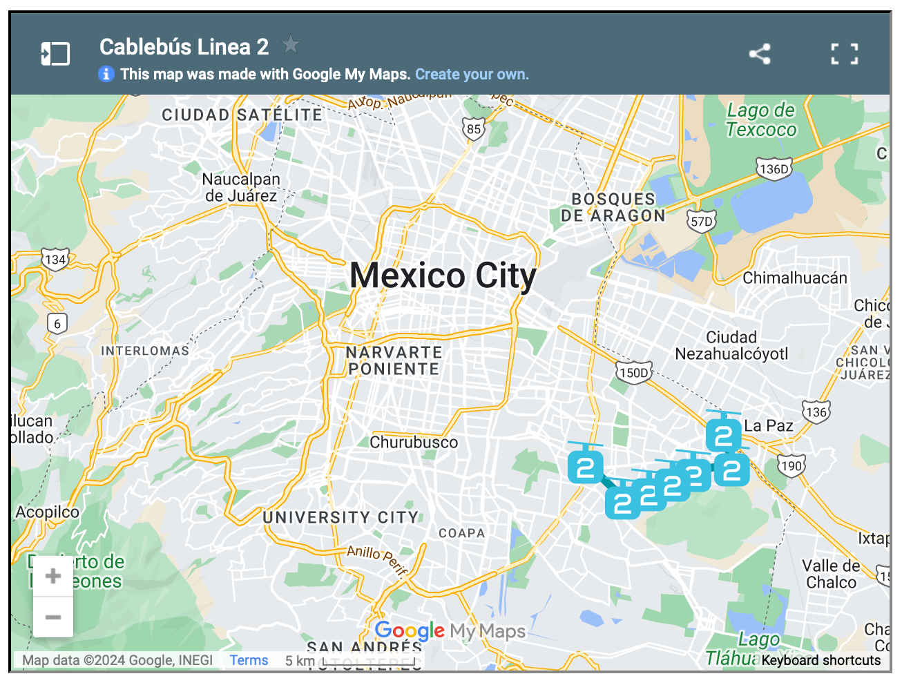
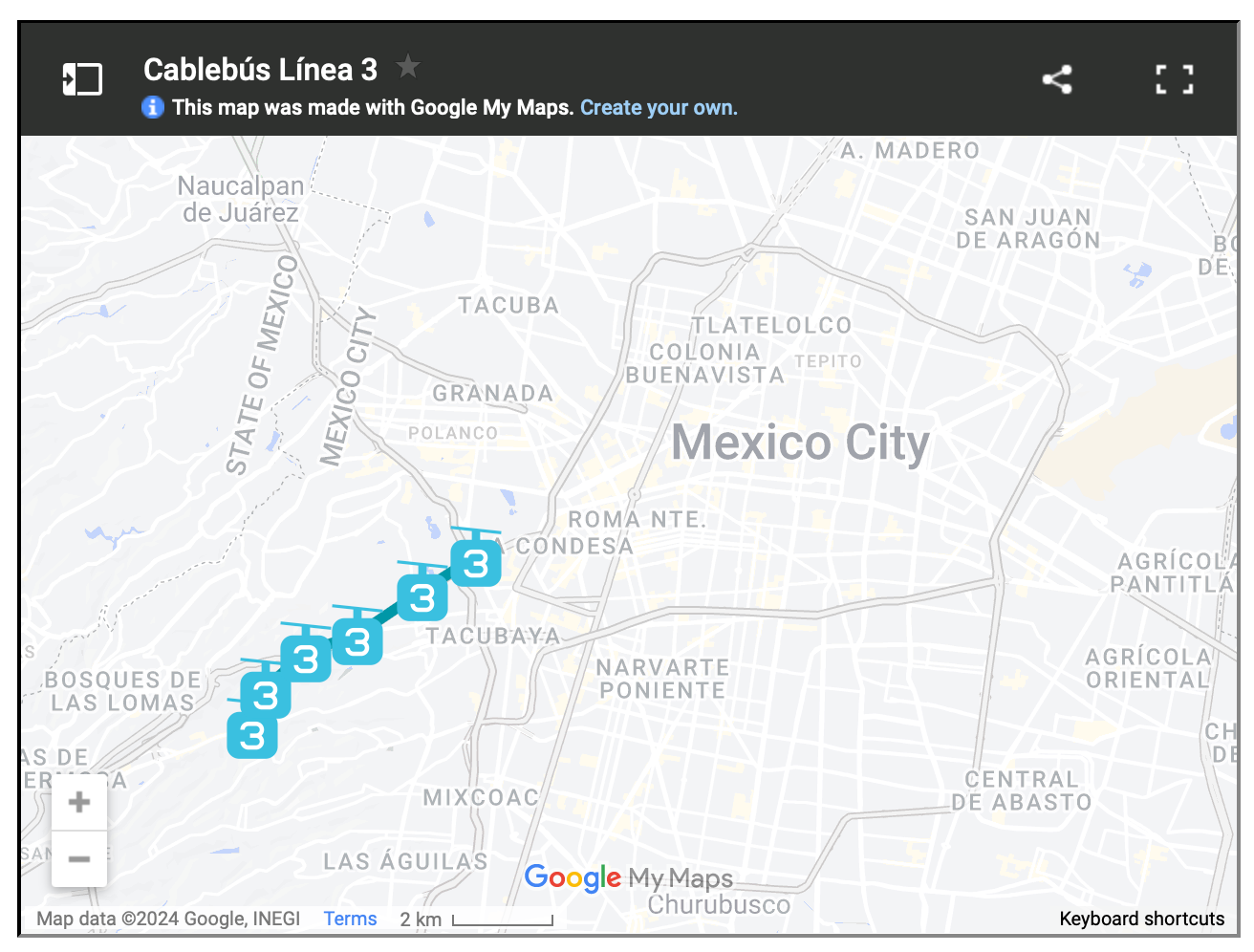
    For reasons like these, Mexico City has spent the last three years building three new cable car lines, the most recent of which opened just last month. The city now has the longest cable car line in the world. But more importantly, it has a new transit add-on that is moving up to 80,000 people per day.

    This isn’t as much as rail. But that’s okay. The point of these lines is to bring more people closer in so that they can then connect to more services and other mobility options. And to do it quickly. Three new lines in three years is impressive. And from the sounds of it, it has transformed many people’s lives for the better.

    Here are maps of the 3 lines, zoomed out a bit so that you can see how they fit into the city’s broader urban context:

  • I’d actually like a Tesla bicycle

    I watched Tesla’s We, Robot event last night. As many of you know, Elon and his team showcased a Cybercab, Robovan, and a humanoid robot that dances funny, all of which will be available in the market for purchase at some unknowable date in the future. What was obvious is that Elon himself has no clear idea of when this will be.

    What I will say, though, is that the designs look cool. The Cybercab looks like a Porsche and a Cybertruck had a love child, and the Robovan looks like an Art Deco rendition of what the future is supposed to be like. I first wondered why they’d create a robotaxi with only two seats. But thinking about it now, most Uber rides probably only have 1-2 passengers.

    Despite these pretty designs, the overwhelming reaction to the event seems to be one of disappointment. We’ve heard what was said before. Public transportation is bad (I disagree). Autonomy will free up your time and remove unnecessary parking spaces from our cities (allowing for more public space). And soon you’ll be able to put your under-utilized car to work and earn extra cash.

    Cool, but when?

    Waymo and Uber are not, as far as I know, hosting similarly flashy events. But as far as I can tell, they’re making meaningful progress in advancing toward full autonomy. As of June of this year, Waymo had already logged over 22 million rider-only miles. And in September, they announced a partnership that would bring AVs to Austin and Atlanta by way of the Uber app.

    At this point in the hype cycle, I don’t think anyone is interested in hearing promises about what the future of autonomy will be like, especially without any firm dates. They want to know: Are we there yet? So I think it’s no surprise that people, including investors, weren’t all that pumped up by the event.

    On a more important note, Tesla had bicycles with brightly illuminated wheels circulating around their event set (at Warner Bros.) to presumably demonstrate that their Cybercabs can successfully navigate around moving objects (when brightly illuminated). If you missed them, look at the 29 second mark in the below video:

    I can’t be the only one who thought: “What are those? Now, that’s what I want!” So I’ve asked Elon when they’ll be available and when I can buy one. I’ll keep you all posted on his response.

  • Dupont Street to become a complete street

    The City of Toronto is proposing to turn Dupont Street — between Dundas Street West and Davenport Road — into a “complete street.”

    Here’s the area in question:

    It’s 4.7 kilometers long.

    And here’s how the city thinks about complete streets:

    “Complete streets” are streets that are designed to be safe for all users: people who walk, bicycle, take transit or drive, and people of varying ages and levels of ability. They also consider other uses like sidewalk cafés, street furniture, street trees, utilities, and stormwater management.

    Right now, the city is in the public consultation phase. If you’d like to provide your feedback, you can do that here. You have until October 30th. The online tool is also pretty neat. You can drop comments on specific areas of the street. And already the map has been totally filled up.

    This is an important and busy artery in midtown. I use it all the time as a pedestrian, cyclist, and driver. It’s not the best street, though. Yesterday it took me 45 minutes to drive from one end of it to the other. Along with better street design, this part of the city could use better transit.

    I’m looking forward to seeing how Dupont ultimately gets designed.

  • Density is good

    Here is an interesting chart (source) showing housing starts in Canada, by type, between 2000 and 2023:

    As recent as 2000, single-family houses accounted for 61% of total starts and multi-family housing accounted for 39%. This flipped somewhere around the financial crisis and, last year in 2023, the percentages were 23% and 77%, respectively. This is a meaningful inversion which has helped our cities become more vibrant and more conducive to non-car modes of transport.

    But in this recent article about Canadian housing, Donald Wright more or less argues: so what? We’ve been densifying our cities for all these years, but it hasn’t helped our affordability problem. Supply must not be the answer to our housing crisis.

    I’m not exactly sure what he believes to be the solution, but I don’t think this problem is as simple as “we’ve built some housing, we made our cities denser, and yet housing is still expensive — more supply must not be the answer. Let’s move on.”

    Among many other things, it’s important to understand what kind of density we’ve been building. Because up until very recently, we’ve basically taken the position that single-family neighborhoods should never be touched, and that density should only go in very specific areas — and only after a lengthy and expensive rezoning process has been completed.

    We’ve designed new housing to be expensive.

    But attitudes are changing all across North America. We are now starting to do two very important things: (1) we are opening up more of our cities to intensification and (2) we are now allowing more multi-family housing on an as-of-right basis. Meaning, no lengthy rezoning exercises and no risk of community opposition.

    These are two fundamental changes that should alter the kind of density that gets built. And in my view, it’s going to be a positive thing for Canadian cities.

  • Pedestrian plaza or parking lot?

    It is maybe comforting to know that even Europe wrestles with the decision of whether a grand urban space should be used for pedestrians, or turned into a parking lot. Take, for example, the Grand-Place in Brussels (pictured above).

    Today, it is a UNESCO World Heritage Site and one of the most important tourist destinations in the city. Perhaps its most famous. But during the 1960s, in what Wikipedia calls a “low period of appreciation,” it was a parking lot.

    This lasted until 1972, when a bunch of people from the community got together and lobbied for it to, you know, not be a parking lot. Not surprisingly, local shop owners were worried, at the time, that this would hurt their businesses. This is often the concern.

    Here in Toronto, where we continue to debate the pedestrianization of Kensington Market, we have surveys showing that 94% of visitors to the area support pedestrian-only zones, but that this number drops to 55% when you narrow to people who live/work/own stuff in the area.

    But if your goal is to sell more things to people, then there’s something to be said about listening to what your visitors want. In the case of Grand-Place, pedestrianizing the square made it far more popular as a tourist destination. And I think the same would be true of Kensington Market.

    For some photos of iconic public spaces in Europe being used as parking lots, check out this Politico article.

    Image: Wikipedia Creative Commons

  • Leslie Lookout Park

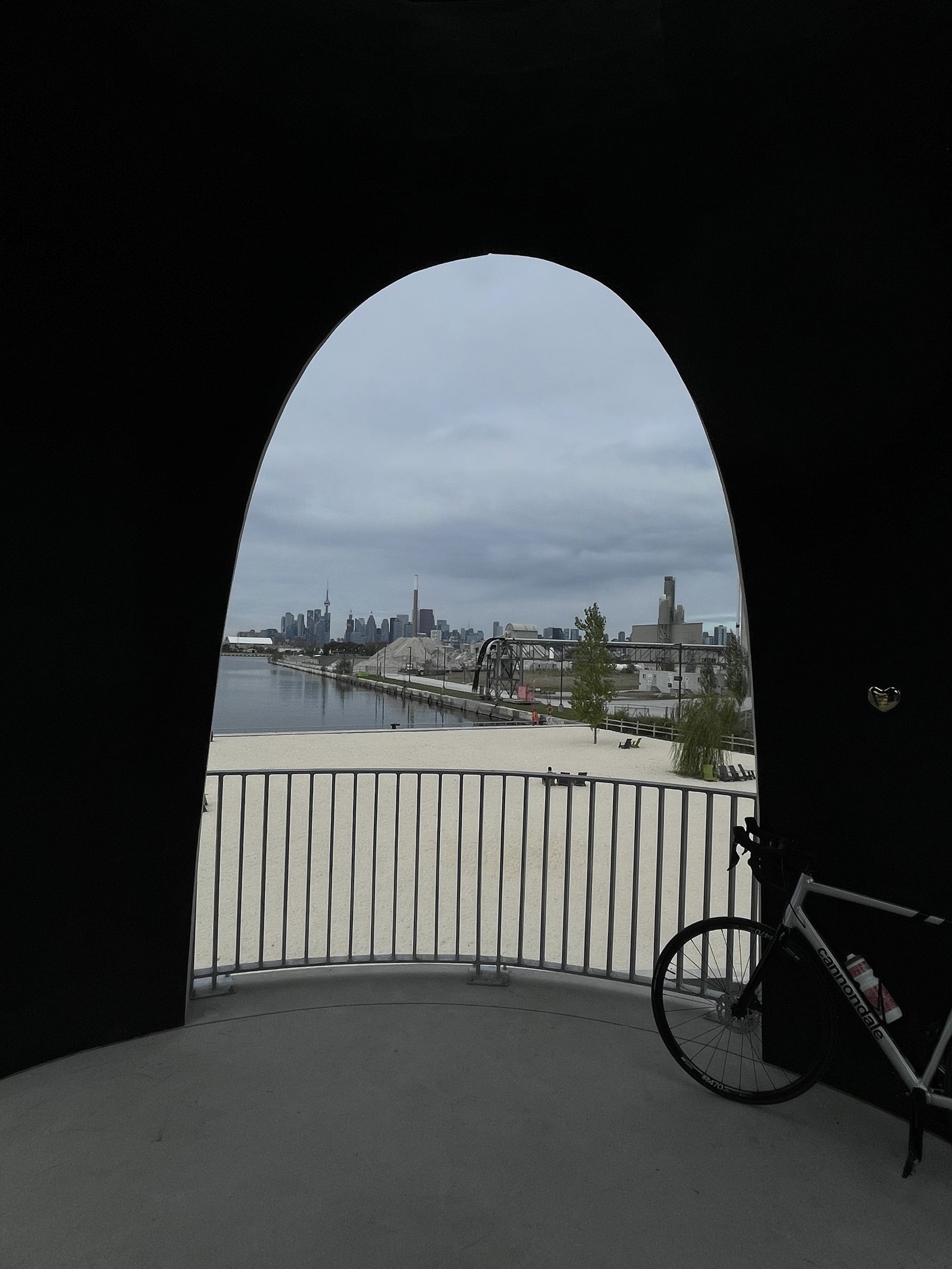
    This morning I rode out to Toronto’s new Leslie Lookout Park, which opened two weeks ago. I came down Cherry Street, crossing the new north bridge, and then I went all along Commissioners Street, crossing its new bridge.

    It’s great to see the Port Lands area continue to develop. Every time I’m down there, it feels more and more real — like an extension of the city. Now we just need to start developing within the blocks.

    If you find yourself at Leslie Lookout, make sure you locate Claude Cormier’s heart up in the tower. Claude’s firm CCxA was the landscape architect behind the project; but sadly, he passed away last year.

    Exactly 1 year before the opening of this park.