Daily insights for city builders, delivered every morning at 6 AM ET. I’m Brandon Donnelly — a Toronto-based real estate developer and founder of Globizen. I’ve been writing here since 2013.
Buildings of Paris from before 1800 vs 1800-1914. A reminder of how overwhelmingly what is widely celebrated in Europe's urban heritage is really the heritage of the long nineteenth century. From this brilliant database: https://t.co/fzXP1SFIQ0pic.twitter.com/8VAwR41mMK
The link is to a figure-ground map of Paris that allows you to filter its buildings by period of construction. Here’s what all of the periods and all of the buildings look like:
Once you play around with the map, it will become obvious that the second half of the 19th century and the early 20th century was a prolific building period for Paris (1231 hectares of area). This is what Samuel was getting at in his tweet.
I would love to see a map like this for every city in the world.
Paris just announced plans to become a “100% cycling city.” A follow-up to plan vélo 2015-2020, which saw a doubling of the city’s bike lanes, plan vélo 2021-2026 includes 130 km of new bike lanes and 52 km of pandemic bike lanes that will now be made permanent.
In addition to cycling lanes, the plans include new bike parking, new transit integrations, and a bunch of other things that are meant to strengthen the overall ecosystem in the city. The total budget for this second plan is about €100 million, which will bring the total cycling investment over the last 10-11 years to about €250 million. This is a serious commitment to cycling.
It’s also a good example of one of the things that we have been talking about on this blog. This pandemic forced us to rethink how we allocate urban space — everything from outdoor restaurant patios to bike lanes. And as we can see here, many of the positive changes are not surprisingly starting to stick.
The last time I was in Paris was in 2006. That’s a long time ago and so it was great to be back in the city earlier this week. I don’t know the city as well as I do many other cities, but I speak enough French to be dangerous and we spent a good amount of time on this trip just exploring. On average, we clocked about 20,000 steps a day. So here’s a list of some of the things I was reminded of or learned of on this visit. If any of you are more familiar with the city, please feel free to speak up in the comment section below.
I love Paris.
The Parisian art of people watching is alive and well. One of my favorite things about Paris is how so much of the cafe seating faces out toward the street. That’s what you’re supposed to be watching: urban life.
Most cities have a clear message. In Los Angeles, it’s probably that you should be more famous. In Boston, it’s arguably that you should be smarter. And in New York, it is perhaps that you should be richer. In Paris, the message feels loud and clear: You should be more fashionable.
Compared to Toronto, the center of Paris feels far more static. Less construction. Less change. Less that is new. That’s not such a bad thing given how beautiful the city is. But in my view, cities are about balancing preservation and progress. From what I could tell, a lot of the new construction seemed to be happening in the suburbs and in the outskirts of the city.
That said, COVID feels much further along in Paris. The city was very open and everyone seemed to be back in the office. Locals said that the city was operating at maybe 80%. It felt busy.
Dress shoes are dead in Paris. Everyone wears cool sneakers no matter how young or old. Think business suits with Nike Air Maxes. My hypothesis is that it’s just far more practical given how much people walk in Paris. I plan to adopt this strategy immediately.
In addition to walking, everyone seemingly bikes and/or uses an electric scooter. Again, it didn’t seem to matter how young or old. Paris also seems to have solved the scooter clutter problem, as has many other cities. There are designated spots (painted lines next to on-street car parking) and that’s where you’ll find the scooters. Toronto needs to get on board.
Traveling at 300 km/h on a train is a highly civilized way to move between urban centers.
There’s nothing wrong with having a picnic and drinking a bottle of wine (or two) in a park. In fact, it is probably something that should be celebrated. Let people be grown-ups.
When you purchase a baguette, you should immediately take a bite out of it to see how fresh it is.
The Eiffel Tower, much like the CN Tower, looks far better when illuminated.
Balconies of any size can be wonderful. We had a small Juliet balcony off of our hotel room in Nice and we used it every day for croissant eating and to dry our bathing suits. In a more permanent situation, I am sure we would have started growing things on it.
Midrise buildings do indeed create nice urban street walls. But it’s important to keep in mind that Paris’ midrise blocks are also deep and dense and with lots of courtyard conditions. That’s how the city is able to house so many people at such low building heights.
Facing conditions between buildings is less of a concern when you employ less glass. Smaller punched windows allow you to better manage privacy. I would go so far as to argue that if Paris were an all-glass city, much of its current built form would be fairly unlivable.
In the world of development, there is something known as a floor space index (FSI). Some places call it a floor area ratio (FAR), but they mean the same thing. It is one measure of density. To calculate it, you simply divide the total building area by the site area. For example, if you had a 25,000 square foot piece of land and you were to build a single storey building that occupied every bit of the site (also 25,000 sf), you would have an FSI or FAR of 1.0. If you built a two storey building on only half of the site, you would similarly have an FSI or FAR of 1.0. The area didn’t change, you just moved things around. That’s how FSI’s work.
A ratio like this tells you how intensely you may be using a piece of land, but it doesn’t tell you everything or necessarily give you the full picture. Which is why I find it silly when too much emphasis is placed on this singular number. I don’t think anyone in the history of the world has ever traveled to a city — let’s take Paris — and remarked how beautiful it is because of its floor space indices. Nobody thinks like this. It’s way too esoteric. What guides our experiences is built form, the ground plane, relationships to streets, materiality, light, context, and many other important things.
To give a specific example, let’s take One Delisle. This project was in effect approved twice. After it was approved by City Council in July 2020 an adjacent land parcel was acquired. It wasn’t absolutely necessary to do this, but we felt it made for better city building and so we did it. (We wanted to look back knowing we did the right thing.) That meant that we needed to go back to Council to revise our approvals, which ended up happening at the beginning of this year (public staff report, here). There was no change to the tower and and no change to any of the key setbacks or stepbacks. But the overall FSI did go down!
Will anyone notice or care about this lower ratio? I doubt it. Which is why I think it’s silly to try and plan our cities around them. It feels like design by spreadsheet. Thankfully, I think many people recognize this.
This is an interesting article by ArchDaily, looking at the “evolution of the house plan in Europe” between 1760 and 1939. The article focuses on London, Paris, Amsterdam, and Moscow and includes floor plans, photographs, as well as well-known illustrations like the one shown above. Created by Bertall in 1845, the drawing shows a section through a Parisian house and is called The Five Floors of the Parisian World.
What it shows is the declining opulence that used to exist in Paris’ apartment blocks as you moved upward. If you were rich, you lived on the second floor, right above the ground floor lobby. The ceilings were higher on this floor and maybe had a balcony overlooking the street. If you lived on the third floor it meant that you were a less rich. And if you lived in the top floor attic, you were poor. That is what this comic is showing.
Now, all of this changed over time as new technologies, namely the elevator, were brought to multi-family buildings. All of a sudden it became convenient to live higher up and all of a sudden people wanted better views and to get further away from the chaos of the street. What I’m curious about, though, is how posterity dealt with the lower ceiling heights on these upper floors.
For years, French photographer Ludwig Favre has been doing a series on the swimming pools of Paris. The first one he photographed (and the first photo below) was the Piscine Pontoise. Designed in 1933 by architect Lucien Pollet, Pontoise was one of four pools that he completed for the Piscines de France at that time. Another one of his designs was the Piscine Molitor (second picture below), which is the most famous of the bunch for a few reasons. It was the place to be seen in Paris when it first opened. It was where the world’s first bikini was apparently unveiled. And it was also abandoned and almost demolished, during which time it got filled with street art. If you aren’t familiar with the work of Ludwig, I would encourage you to check out his portfolio. He does an incredible job showcasing these pools, as well as many other aspects of our cityscapes.
In this January 2018 report from the Fraser Institute, they pegged the average population density of Paris to be about 21,067 inhabitants per square kilometer (2014 population year). It is the second densest city in their report after Hong Kong, but the densest in Europe. By comparison, Vancouver sits at around 5,493 inhabitants per square kilometer (2016 population year).
Now, these are of course city averages. Some neighborhoods will be higher and some will be lower. According to a January 2018 study by Alasdair Rae — who is a works in the Department of Urban Studies and Planning at the University of Sheffield — these are the most densely populated square kilometers across Europe (or at least within the 39 countries that he looked at).
Paris, once again, comes in near the top with a peak density somewhere around 52,218 inhabitants per 1km square. The square in question is in the neighborhood of Goutte D’Or. And the only square within the study to come in denser is one from the L’Hospitalet de Llobegrat in Greater Barcelona (53,119 inhabitants per square kilometer).
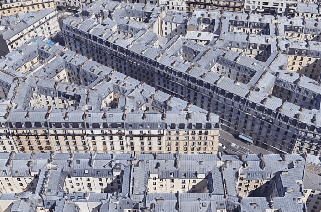
Now let’s take a look at how these sorts of densities actually manifest themselves. Below is an aerial capture from Google Maps showing a section of Goutte D’Or in Paris. The buildings are all pretty much 7 storeys (mid-rise), but the blocks are mostly filled in. Lots of interior courtyard apartments. This is one way to get to over 50,000 people per square kilometer.
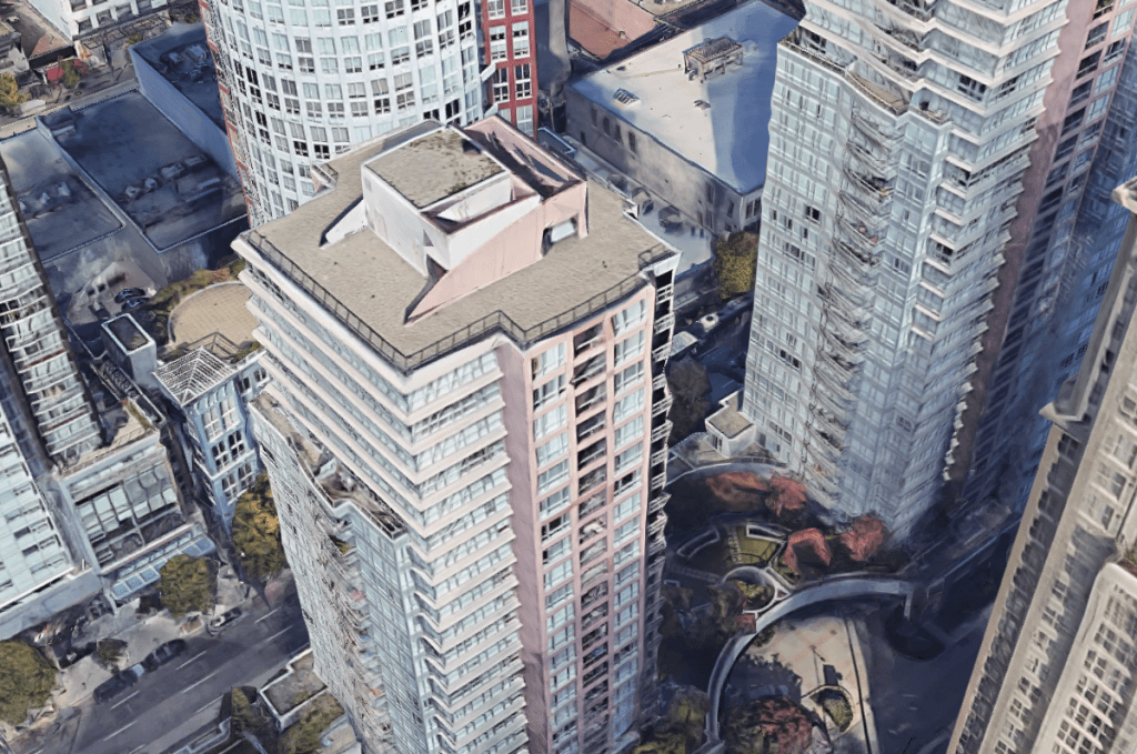
Returning to Vancouver as a point of comparison, below is an aerial capture from downtown Vancouver at exactly the same scale as the Paris capture. I couldn’t find a density map of downtown, but it’s probably safe to assume that it’s greater than 5,493 and a lot less than 52,218 residents per square kilometer.
What you see here is typical Vancouverism. Lots of slender point towers, careful tower positioning and spacing, and generally low podiums. It is a perfect demonstration that height and density do not necessarily correlate. It is possible to have low buildings and high density, which is something that Europe obviously does very well.
But here’s the important question: In which of these two examples would you rather live? Please leave a comment below.
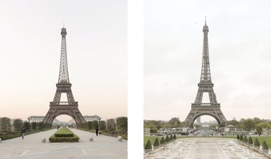
French photographer and graphic designer François Prost has a new photo series out that I thought I would share with you today. It’s called “Paris Syndrome” and I discovered it via CityLab.
What the series does is visually compare Paris to a housing estate in Hangzhou, China called Tianducheng, which was designed to be a replica of Paris. Tianducheng even has its own Eiffel Tower, though this Chinese version is only 108m tall and the French original is 324m.
Still, in many of François’ photos, you may find it difficult to distinguish between the two (provided you ignore the Chinese people and the Chinese signs). The neighborhood was initially a ghost town, but apparently it’s now starting to fill up.
The reason I mention this photo series is because it reminded me of the day that I spent in Macau last week. I’m not much for gambling – and Macau is firmly the gambling capital of the world with revenues that greatly exceed Las Vegas – but I was curious to see it.
Similar to Hong Kong, Macau is a Chinese Special Administrative Region with a lot of autonomy. But from 1557 to 1999 it was under Portuguese administration. And so historically it has been home to this very unique Eurasian culture spanning everything from food to language.
I say “historically” because the Macanese and their Patuá language – which is supposedly a blend of Portuguese, Cantonese and Malay – seem to be on the brink of extinction.
Today it’s all about the casinos. And the demand is firmly coming from mainland China. In 2016, 90% of Macau’s 31 million tourists came from there.
I fully appreciate the demand drivers, but I struggle to understand the allure of replicating and bastardizing attractions from other places. Macau also has an Eiffel Tower, as well as a Venetian (like Las Vegas). You can go for gondola rides in its canals.
The more interesting part for me was the historic center of Macau with its Portuguese paving on the sidewalks. But maybe that’s just me.